

Hurricane Agnes
-
Posts
8,953 -
Joined
Content Type
Profiles
Blogs
Forums
American Weather
Media Demo
Store
Gallery
Everything posted by Hurricane Agnes
-
They didn't change it with the update unless they have to issue another correction. I would agree that I haven't seen anything higher than 81 kts with the recent drops although there is a newer recon in there still working.
-
Somebody was looking for you last night I think -
-
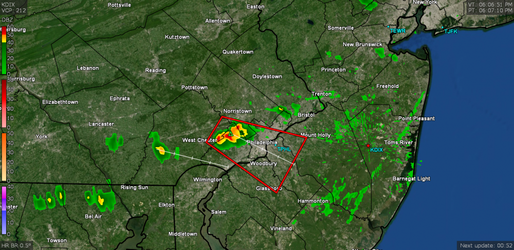
Severe Thunderstorm Warning just issued for parts of the area (it will probably miss me to the south by a few miles) - Otherwise it just tapped 89 here after a low of 67. Currently 87 and overcast with dews that have held in the low 70s much of today.
-
I saw a tweet with a corrected version.
-
Sandy took out the remaining 4 street trees that survived after Irene took out 6 others on that street the year before.
-
Josh is up in the air on his way to Abaco per his latest tweet -
-
It's moving (MW last 24 hours) -
-
Overall nice late summer day yesterday with a high of 82 after a low of 66 here. Today is supposed to be the warmest of the near/long term but I don't think I'll make it to 90 here today, especially if the overcast this morning manages to persist (at least in part) during the day. Currently mostly cloudy and 70 (where I actually had a low of 67 around 1:30 am and have been experiencing non-diurnal warming since).
-
I expect the government of that island may end up operating out of Nassau, which got a less significant blow (although had significant flooding despite no direct hit). The airport there was open but with obvious delays.
-
His 4th tweet (around the time of the previous ones) -
-
He had 3 tweets. The other 2 -
-
He does have a show premiere coming up - I think September 15.
-
Adding my here!
-
Well I got shafted from the last line. Got an additional 0.10" for a total of 0.17" for the day so far. Managed to make it up to 84 before the rain and am currently overcast but clearing and a steamy 73 with dews now in the upper 60s.
-
Wow. You really got into a precip hole. I at least managed 4.39" for August and I know I was fringed or got missed by a bunch of storms.
-
I think that when it gets up here it will probably zoom on out and not sit and spin - unless the timing gets messed up and it misses getting ingested into any troughs or fronts that would normally sweep it away to the NE. I actually got fringed by the cluster of storms that have been coming through this morning - the heaviest going just a few miles to my north. I did get 0.07" out of it (so far) and it's currently 72 (after a low of 68 and a high before the rain of 75). Had a pretty nice day yesterday too with some breezes, a 64 low and 82 high.
-
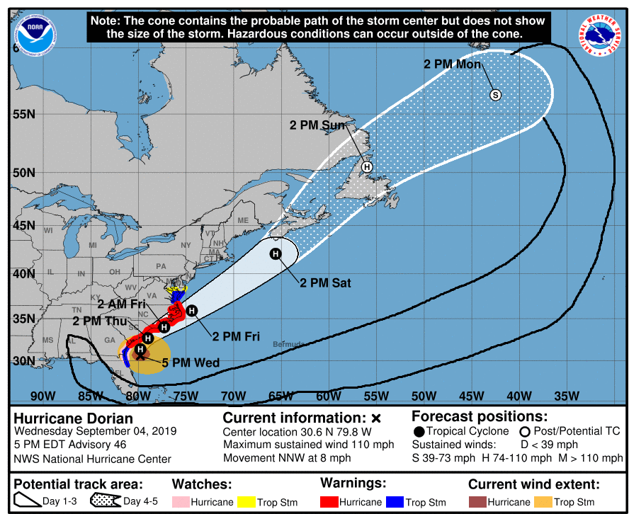
If that latest update verified, it would definitely be a nightmare - i.e., coastal southeast Florida appears to be in the relative center of the cone's extrapolated "central line". There are strips of barrier islands all up and down the coast and with it being low-lying and swampy anyway, any storm surge would probably travel quite a bit inland. Just seeing the real-time storm surge video from Michael's landfall in the pan handle last year, was jaw-dropping.
-
If Dorian decides to come up the coast, you might see something. As an obs, after a low of 60 this morning (thought it could have gone a bit lower here but didn't), am now up to 85 with dps that have slowly increased through the morning to the low 60s (after low 50s yesterday). Still... there's been a perfectly blue sky so far today so it looks like a great start to the long Labor Day weekend.
-
Oh geez. Let's hope that doesn't verify although I would think that "look" would be welcomed in winter around these parts. Made it up to 81 here today after a cool low of 62. Very different today than the past couple days by not having any overcast/marine influence issues. Pretty much blue sky all day (with an occasional cloud here and there) and low humidity to boot, with dews in the low 50s. Currently 77 and sunny.
-
I think because of incidents like this (1/26 - 1/27/15) - http://www.philly.com/philly/news/Meteorologists_apologize_for_busted_forecast.html Many were hugging the Euro and dissing the lowly GFS - http://www.philly.com/philly/blogs/weather/Snow-What-went-wrong.html I think that is why today, you are seeing folks bemoaning the rise and fall of the mighty Euro.... and as much as we laugh about being "NAM'd", I expect that sometimes the NAM does have the right idea but with the details obscured in the overdoneness of a burnt steak on the barbie. You can hunt around and find the pbp thread(s) here in the forum of that 2015 flizzard.
-
Maybe GOES-16 will help (or not) - https://www.nesdis.noaa.gov/GOES-R-Launch Still a ways off from what impact that will have in the future, but it will have some just due to the resolution of its instruments. I think a lot of what we see today is also driven by the 24/7 world where schools, businesses, and governmental entities increasingly demand precise measures in order to activate certain responses to the more severe sensible weather (i.e., closures, postponements, evacuations) and that leads to model-hugging in order to tease out those numbers and report them as soon as possible. However we have seen time and time again a long range model "see" something 10 days out and then lose it in the mid-range, and then resurrect it again in the short range/nowcast period. IMHO, that type of whiplash seems to cause some to overthink or lose the forest for the trees. Overall, I doubt at this point that "weather" for mass consumption will ever go back to appealing to met fans. TWC used to do it but long sense decided to leave that niche world and go for drama over substance.
-
Attention All Philly Subforum Members
Hurricane Agnes replied to Rjay's topic in Philadelphia Region
The true story (need to go to youtube to view) - -
Attention All Philly Subforum Members
Hurricane Agnes replied to Rjay's topic in Philadelphia Region
When a storm threat is on the horizon, folks reappear rather quickly and do some great pbps of the models. The past year, winter weather lovers got a screw job. There is just a different climatological thing going on here compared to D.C. or NYC metro. -
Attention All Philly Subforum Members
Hurricane Agnes replied to Rjay's topic in Philadelphia Region
The "pile" will make itself. Won't need to shovel to create one with this storm. -
Attention All Philly Subforum Members
Hurricane Agnes replied to Rjay's topic in Philadelphia Region
There you are! People thought our resident squirrel fled to chase a blizzard elsewhere!


