Hurricane Agnes
-
Posts
9,276 -
Joined
Content Type
Profiles
Blogs
Forums
American Weather
Media Demo
Store
Gallery
Everything posted by Hurricane Agnes
-
I was watching Governor Wolf's presser out in Harrisburg and as soon as he started, the rains came and he and others out there were asking if anyone had any umbrellas. There was a return sitting right over that area. The overcast/stratus kept the temps down until the afternoon when the sun finally came out and up the temp went. I so far hit 91 as a high today (just after 1:30 pm) but the dp has been the story of the day. Currently partly sunny and 90 with dp 78.
-
The rain gods gave me 0.07" very early this morning, hopefully staving off the hose for another day. Seemed to have a repeat type of convective line move through the same way that one did last night, although this one seems pretty juicy in Jersey in Burlington county. I think I may be at my low as a current - 72, with a dp of 71, meaning steamy windows alert, and there's stratus blanketing the area. Excessive heat products are up (Warnings for Philly metro + north and east into Jersey, and Advisories for the next set of counties out).
-
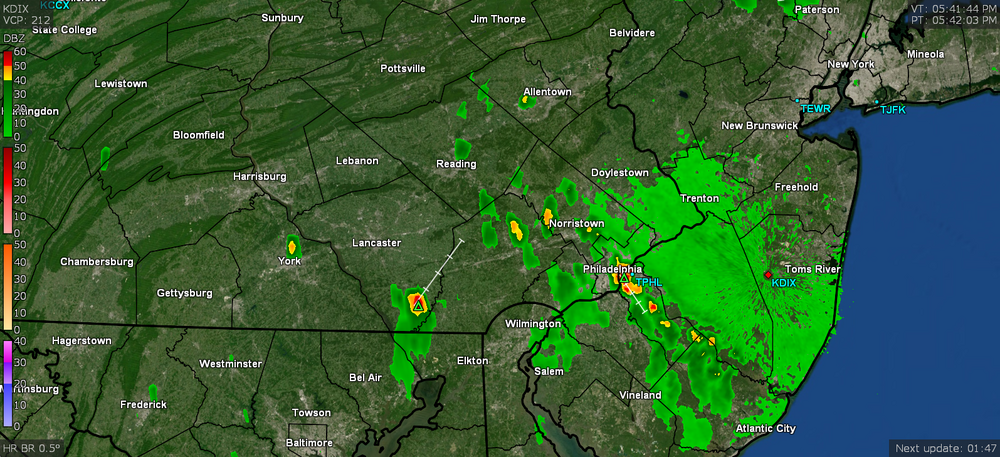
Man... getting fringed and in a hole. Hoping to get a couple tenths of an inch out of something tonight. I was watching the ocean breeze come inland and then it smacked up against the outflow boundary from the convection. It was cool to see it on the radar though. Still overcast and temp still at 81 with dp 72.
-
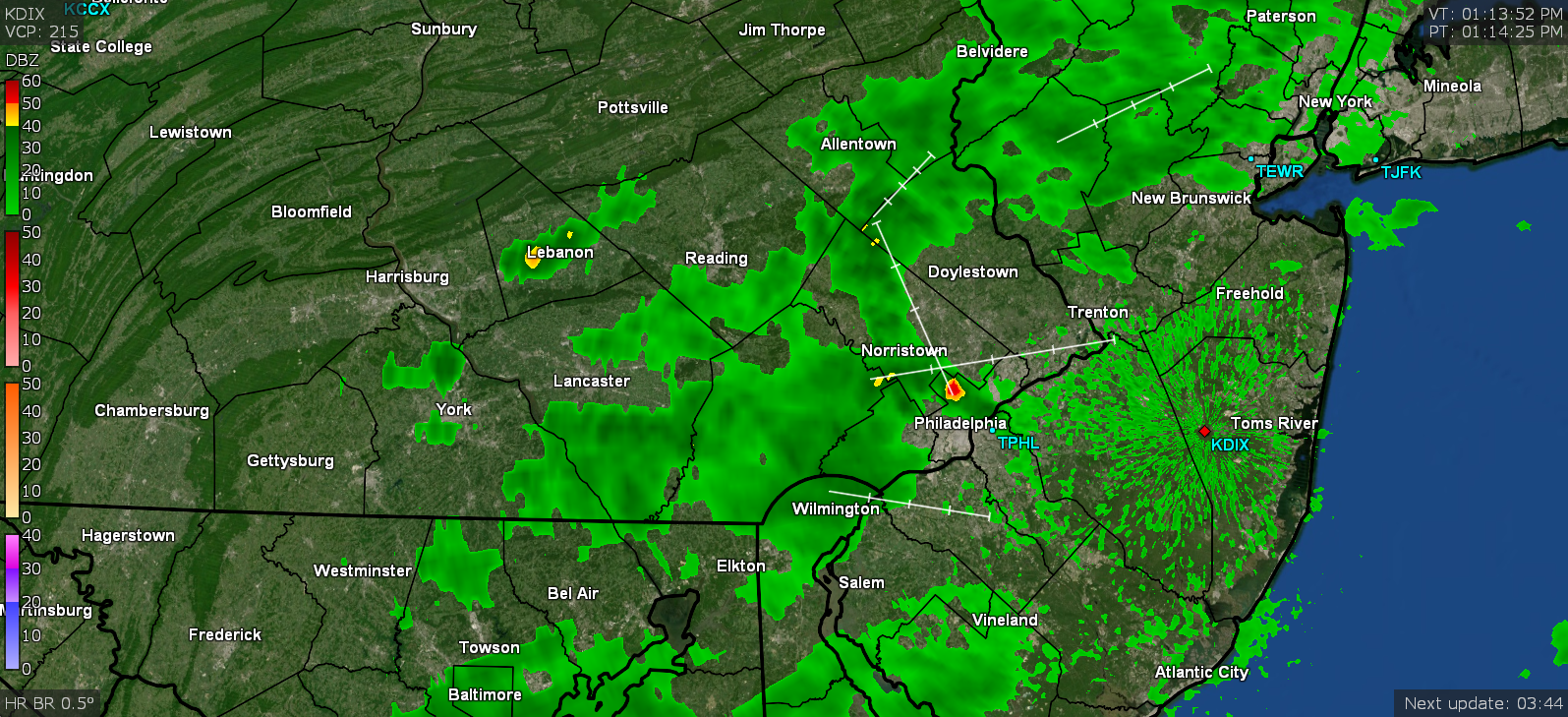
I am literally in between a couple tiny blobs. My detector is picking up the radius of 4 miles on either side... Temp is down to 81 but dp is a juicy 73.
-
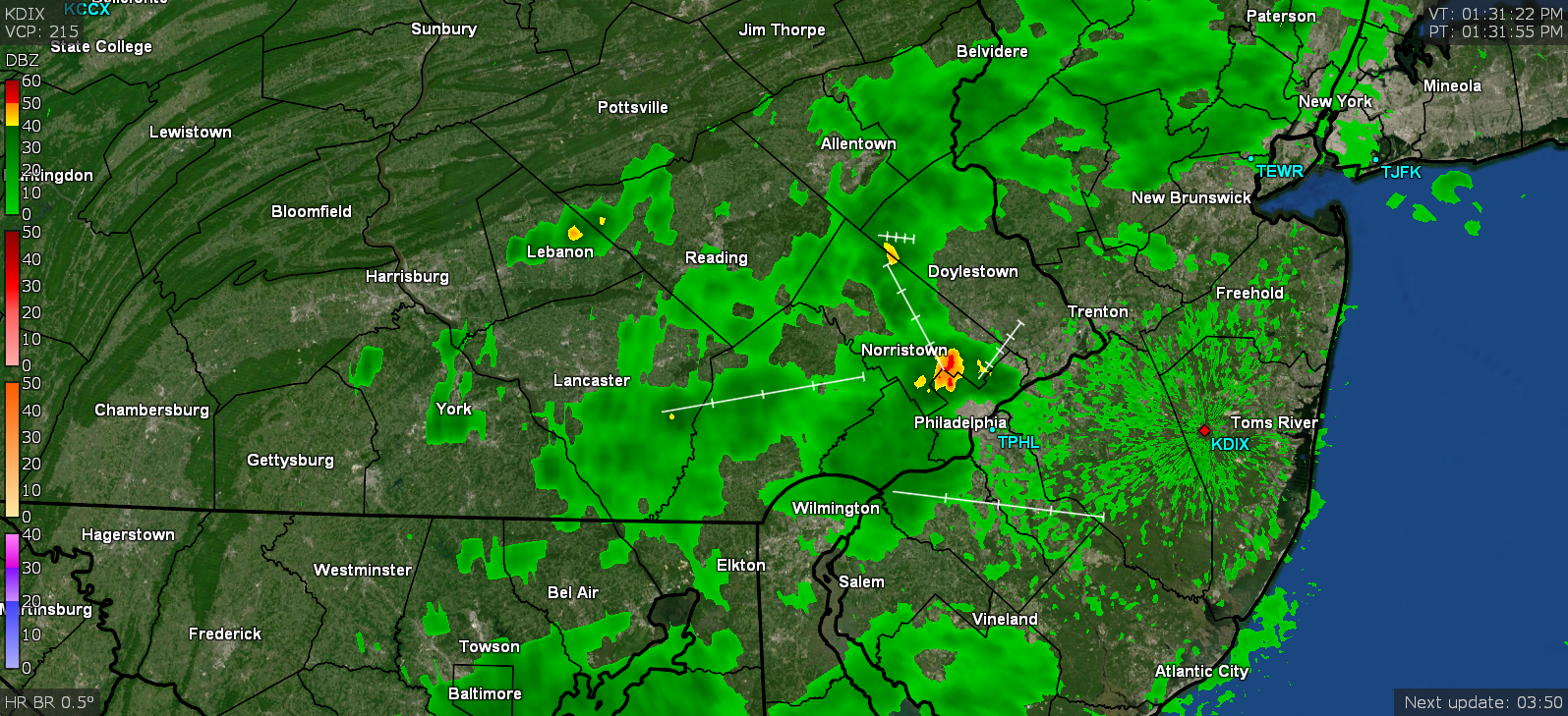
Looks like stuff has started firing in a wild-looking line. I am sortof under the thinned out portion of it but there are some threatening dark clouds and lightning is popping up on my detector. Currently overcast and 82 with dp 72.
-
I had told my BIL that the Dawn redwoods were deciduous and not to get alarmed when it dropped its needles. He was fine with that since the guy at the nursery we frequent had recommended it to him and he trusted the guy. He had also bought a couple Witch Hazels around the same time that are now almost 10ft tall. Didn't realize they could grow that tall although I understand there are some varieties that have an upright form. They ended up becoming a nice screen for their shed. The one thing I haven't really seen this year, thank goodness, are the swarms of lanternflies. Earlier I saw maybe one or two crawling on the side of the front of the house but that is about it. This time last year they were obnoxiously everywhere. Ended up with a late-in-the-day high of 82 yesterday, with a low of 67 this morning. Had to run out to the supermarket early this morning and although it was in the upper 70s at the time, I could feel a bit of the humidity already creeping in. It's currently partly cloudy and 87 with dp 69.
-
One of my BILs proudly planted a "small" (I think it was about 2ft tall at the time) Dawn Redwood I guess about 15 years ago and then had to move it about 5 years later because it was outgrowing the spot near the house (he moved it under a silver maple near the creek at the base of their property) and it has to be at least 20 ft or more tall growing under a tree canopy now. He manages to find trees that he swore were labeled as "miniature" used for bonsai and one included what turned out to be a fast grower that my sis finally had identified by an arborist as a Japanese Zelkova. Literally in 10 years it went from about 12" to what has to be at least 25 feet. It has provided great shade for their deck that faces south and was always brutal in summer - especially in the late afternoon. That tree shades it perfectly along the hottest side now since it was planted to the west of the deck. I fell short of 90 yesterday but did make it up to 88. Had a low of 68 this morning and was grateful that I was able to cash in on a little rain this morning. I didn't expect anything despite the forecast of possible rain this far north. Ended up with 0.38" so I'll take it. Saves me from pulling out the hose today. It's currently mostly cloudy with some breaks of sun and 72 with dp 65.
-
Ended up with a high of 90 on the nose yesterday, as my 25th of the season so far (now the first of an upcoming string of them, although will have to see how things pan out this weekend and any cloud cover effects). Low this morning was 66 and currently 68 with dp 65, and starting to cloud over a bit with a deck of some high clouds.
-
I know there are (anecdotal) climatological times of the year when it does get "dry" and it's often August/September, where we are often wishing for some TC to bring in the rain to break the spell. I'll probably have to whip out the hose too but in one respect, lucked out watering last Sunday, which prompted almost an inch of rain on top of that. And with the cooler temps, that helped. I ended up with a high of 78 yesterday that will now be history for a high temp per what is expected for the next week or so. Low this morning was 64 and have already tapped 90 about 10 minutes ago but am back to 89 at post time with dp creeping up and now at 69.
-
Yesterday I didn't make it to 80 and had a high of 78, although my 63 low was a little warmer than previous mornings. This morning's low was 61, some cool-looking altocumulus that were overhead here disappeared, and am currently all blue sky and 77 with dp 63.
-
My mom used to love those and I forgot where she would get them (sometimes her sister would bring a bunch down from NH when she visited over the summer), but she would dry them and then keep them in an old umbrella stand in the sun porch as decoration. Of course we had to be careful lest they explode and deposit tufty seeds all over the place. The sun managed to pop out for a bit this afternoon and that sent the temps up. Wasn't sure if I'd get to 80 but I did as a high and it's currently back down to 78 and mostly cloudy again, with dp 53.
-
I just pull out my old school "punks" and call it a day. I ended up hitting 80 for a high yesterday and 61 for a low this morning. There was some early low stratus that made a brief appearance before sunrise here and that gave way to a general cloud deck, and an overcast sky most of the day so far. Currently overcast and 77 with dp 55.
-
That final line that came through here gave me 0.21" and along with the first round's 0.76", total for the event was 0.97". My high for yesterday was 74 and it's currently 59 and clear about 15 minutes before sunrise, with dp about the same, but with enough puffs of a breeze to preclude any fog.
-
AND in reply to a tweet asking about the Bethany/Dewey/Rehoboth DE funnel/waterspout, I finally saw their assessment - That was one of the "earlier" ones in the outbreak that I had been following as it happened so I am glad to finally see what the assessment was there.
-
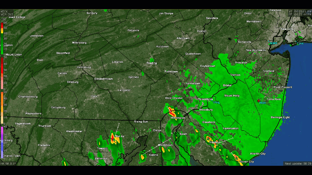
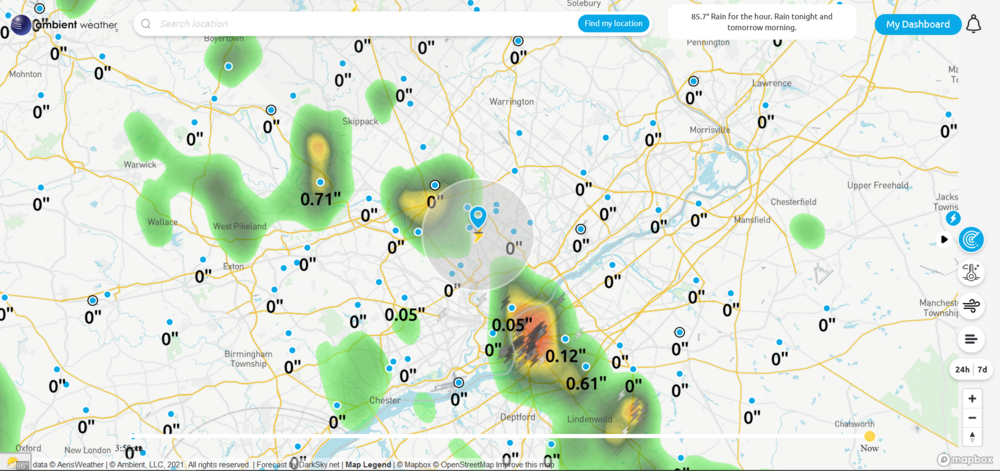
Well after a point where I got > 2.6"/hour rates, I picked up 0.76" (so far) from that little pop-up blob. Temp is currently down to 68 (I think it had dropped as low as 67 during the rain but is recovering), with dp 67, and still have a little light rain. Hopefully that (plus my strategic hose watering this morning) will hold me for a few days.
-
Well Mother Nature "showed me". Bulls eye with > 1.5"/hour rates. Currently at 0.50" at post time.
-
LOL and right on queue... Temp is currently 73 with dp 67 and this little guy that just popped up.
-
I know people in TX haven't been complaining (but have been confused nonetheless). The people in the NW have gotten the SW's triple digit temps. Will be interesting to see when that pattern eventually flips (they usually do at some point).
-
My low today was a bit higher than yesterday's at 62. I was looking at Mt. Holly's forecast this morning and it appears the rain chances for today pretty much evaporated before my eyes (now progged mostly to the north or south of me), so out came the hose this morning. When I pulled it out, a few taunting sprinkles appeared but I was undeterred and plowed on... Currently overcast and 71 with dp 65, so definitely feeling much more humid today.
-
As a side note on Limerick, I remember back in my senior year of HS when my AP Physics class took a field trip to that Limerick plant when it was still under construction. This was back in '78/'79 and I think one of the cooling towers may have been built by then but it would be awhile before any reactor was started up and generating electricity. We got a little dog and pony show from PECO about how the reactor would work (basically having the heat boil the water to create the steam that would turn the turbine to generate the electricity) and I remember they had some interactive display things including one of those bicycle generators that you could try out to light up a bulb. Back then they "promised" that when the plant came online, it would drop the average electric bill down to $3/month "by 1995". I think we actually did that trip before Three Mile Island had it's partial meltdown. Since I got fringed by the rain, gotta get out there and water now but the temps are perfect otherwise. Currently 76 with dp 52 and blue sky (the high clouds have pretty much cleared out).
-
Well I was just hunting around on the map for the EF3 in Trevose and realized that wasn't far from where I used to go to one of the drive-in cinemas in the area - the Lincoln Drive-In (before it started showing the porn movies ). It was not that far from that Faulkner dealership that took the brunt of the tornado. I remember seeing the original "The Godfather" and "Ben" there when they first came out in '72. Back then, they would have the $1 a carload specials. From what I read, the location is now the Neshaminy Interplex office park. Am currently up to 71 with dp 51, and a deck of high clouds have been coming and going, but are clearing out.
-
I'm still waiting to see what the verdict was on the Rehoboth/Dewey Beach possible tornado... I know it was on Mt. Holly's review list. https://www.capegazette.com/article/home-struck-lightning-tornado-spotted-july-29-storm/224448 Maybe it was just considered a waterspout and/or a funnel that didn't touch down. ETA - I don't even hear about tornadoes in Kansas anymore. I guess that was so 1939.
-
Apparently the last EF3 in the state was in 2004 in Campbelltown, which is just outside of Hershey - The Limerick one was in 1994 - https://www.nbcphiladelphia.com/news/local/20-years-ago-deadly-limerick-township-tornado/128147/ To this day I always say they were fortunate it didn't damage that nuclear plant or its cooling towers. In fact I saw where NRC had a conference this past March to present updated tornado risk maps to be used to modify the building design criteria - mainly due to what happened in Joplin (which was 10 years ago this year). As an obs (and I know Birds69 is cheering this it along with the Eagles training camp start ), my low so far this morning has been 58. It's currently 59 and partly cloudy with it being not long after sunrise, with dp 52.
-
Whole pile of tornado reports from Mt. Holly today - And the outcomes (I expect the Rehoboth/Dewey Beach area one in Delaware is still pending) - As an obs, I actually did drop a degree this morning for a low of 71. Made it up to 87 today for a high, and although it took awhile, the dp finally dropped into the 50s, and it's currently 84 and mostly sunny, with dp 55.
-
Have been looking at the damage reports. That area has really been hit this year between the flooding rains earlier this month and now this. So far my low this morning has been 72 and it's currently 72 with dp 70 about 30 minutes before sunrise, and partly cloudy.