Hurricane Agnes
-
Posts
9,264 -
Joined
Content Type
Profiles
Blogs
Forums
American Weather
Media Demo
Store
Gallery
Everything posted by Hurricane Agnes
-
Has been rocking and rolling here and just now starting to rain. Line coming up from the south.
-
Depends on which way they face. I know the back of my house faces NE and I am guaranteed a good outside "window washing" from any nor'easter that comes my way.
-
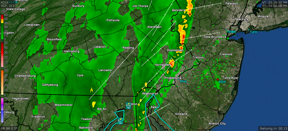
Some Warnings and SPSs for the arear (mostly south and west) - Plus one about to expire in around 5 minutes from post time -
-
Attention All Philly Subforum Members
Hurricane Agnes replied to Rjay's topic in Philadelphia Region
I was gonna say it seems to be an "annual" thing but the last attempt was 2 years ago. I think with a faux-Miller B setup thingy about to happen and what will be 2 potential nor'easters, it's about to get busy in here. -
Have now tapped 76 here with dp bopping between 60 and 61.
-
They are bopping around but currently at 77 again -
-
KPHL record breaker for temp today (was low-hanging fruit) - So far my high today has been 75 with more cumulus rolling in, and it's currently 75 with dp 64.
-
FF Watched expanded across the river -
-
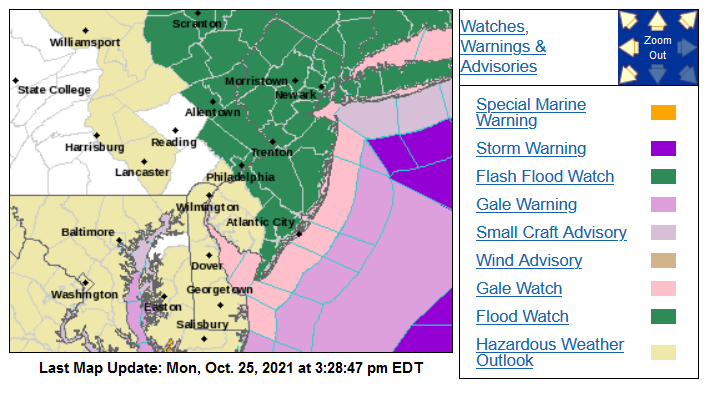
SPC's SWDY1 broadened the risk area (I suppose to reflect the more zonal flow at this latitude), although we are still in the marginal risk carve out - WPC has its forecast for the PNW storm's path here -
-
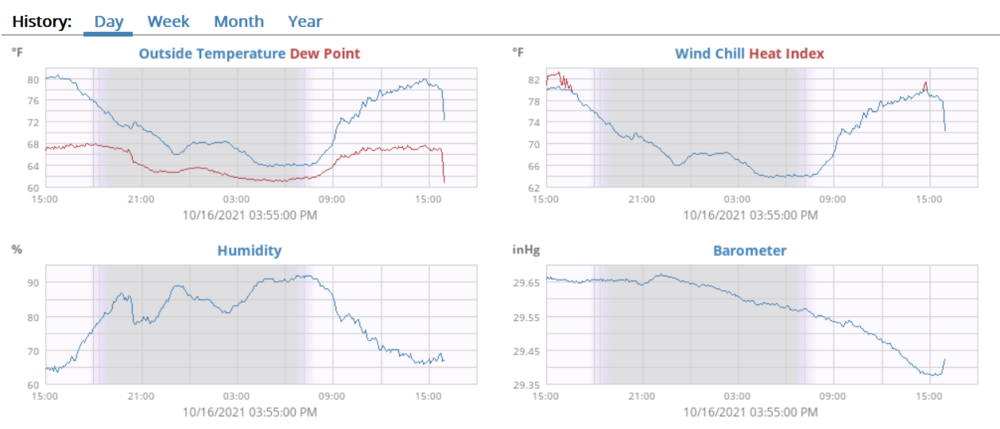
I finally "bottomed out" at 53 just before 4 am before the temps started heading off to the races. Took a bit for the overcast to break up with the lifting of the warm front, but it finally did. Currently partly cloudy and 70 with dp 64, having shot up almost 20 degrees from yesterday's dp that was in the low-mid 40s.
-
May end up with a non-diurnal temp thing going on here. Temp has slowly crept up and hit a high of 59 just before 4 pm when the sun stayed out for a more extended period of time. But then with a warm front approaching, the temps are supposed to remain in the mid-upper 50s in the urban areas overnight. Currently partly sunny with lots of high clouds and 59 with dp 48. SPC SWDY2 has the CWA in the marginal risk. Will see if that changes depending on temps tomorrow, which include some possible RERs -
-
Bottomed out at 43 this morning and am currently up to 46, with a deck of some CAA clouds (with a few breaks), and dp of 45, so seeing some condensate on car windows outside...
-
I have the 2nd batch that has come through (still some sprinkles with it) giving me another 0.01" (total 0.04") but also netting me a rainbow when the sun popped out.
-
Nice!! I had a little shower here (about to get another soon) but forgot to look for a rainbow once the sun came out. Got 0.03" from the first little batch and another batch looks to be out over Chester County at the moment. Currently overcast again (after about a half hour of sun previously) and down to 57 with dp up to 53, after an earlier high of 61.
-
I usually check in with Mt. Holly's web page for info at least twice a day and just noticed they had a link to a "virtual tour" video of their office that was uploaded on YouTube last month. Wanted to drop it here since we are obviously their CWA. Nice job on the tour (and nice office considered the fed building that I worked in (and retired from), although historic, left a lot to be desired )!
-
Hit 66 as a high yesterday with a surprising (but perhaps not so much due to the 2nd cold front coming through overnight) low of 48 very early this morning, before recovering. Currently overcast and 52 with a much lower dp than yesterday, of 46.
-
This is when the nor'easters come into play. I suppose like what often happens briefly in May, this is a good time for roofers!
-
Yeah I noticed the oaks look awful, sortof brown and crispy And after almost 11" of rain in July and 8.5" in August, I so far only have 2.30" this month. Am glad I did get about 1/2" a week ago. Currently 65 and sunny, with dp 52.
-
Ended up with a high of 74 yesterday and a low of 58 this morning. When I was out driving around yesterday, I did notice some of the sugar maples starting to color up but not much leaf drop yet. Often we get some kind of windy nor'easter that helps with leaf abscission for the first drop. Seems the season quarters have shifted where we have the extension of "late summer" into Sep-Oct-Nov and the extension of "late winter" into Mar-Apr-May. Some of this could be La Nina too... Currently 64, with dp 51 and mostly sunny with a few cumulus here and there (more sun so far than progged). The first (weak) cold front has come through barely noticed but the 2nd is supposed to bring the cooler air.
-
Finished with a high of 67 yesterday and had a much warmer (by 10 degrees) low this morning of 51. Currently sunny and 69, with dp 53. A nice fall day so far!
-
Wowser. I bottomed out at 41 early this morning around 3:30 am, with clear skies and no wind. When I came down for coffee around 4:20 am it was still at the 41 F mark. Then apparently a few puffs of wind mixed it out somewhere between about 4:30 - 5 am, warming me up to the mid-40s. Currently 45 and clear with dp 40. If the 40s from yesterday morning didn't start to trigger a leaf change, this morning certainly will get the attention of some trees. I know that the Norway maples spread all over the woods here are usually the last to color up though, but I have seen locusts around the area that have lots of tendrils of yellow leaves. We usually had our "first big drop" of leaves around here just before Halloween, with a 2nd drop sometime in mid-November, and whatever is left by the end of November (the city would wait until about the 1st week of December to vacuum up the leaves in certain neighborhoods - notably here - around that time). I think it is supposed to warm up a bit the rest of the week though.
-
Well I hit a high of 61 yesterday and bottomed out at 44 this morning with good radiational cooling. I know that is going to trigger some leaves to color up and I got my tender tropicals indoors just in time (they don't like below the mid-lower 50s at night). It's currently 55 and clear with dp 45.
-
Ended up with a total of 0.49" of rain with the 2 round diffuse bands of showers yesterday and bottomed out at 50 this morning. Currently partly sunny and 51 with dp at 47, an almost 20 degree difference from the dews that were hitting the mid-60s earlier yesterday.
-
Well so far with the initial (sortof) round 1, I got 0.08". No convection picked up by the lightning detector. There's another band to come through so will see if that yields anything. Currently mostly cloudy and 63 with dp 60.
-
I wouldn't even consider what trickled in, a gust front. It looked good in the sky but other than than the active breeze that has been happening on and off today, the dp drop was the most significant indicator (and the sky going dark). Made it up to 80 and it's currently dropping and down to 68 with dp 59. ETA - it's attempting to rain.