Hurricane Agnes
-
Posts
9,264 -
Joined
Content Type
Profiles
Blogs
Forums
American Weather
Media Demo
Store
Gallery
Everything posted by Hurricane Agnes
-
Low this morning was 43 and it's currently sunny and 60 with dp 44. Just seeing this new WPC product change for flood potential - I suppose it makes it easier to deal with although I always interpreted a Flash Flood Watch as a sudden, short duration event vs a Flood Watch as something that could go on for some time (although they apparently still plan to use the FF Watch for certain circumstances).
-
Don't forget the temper tantrums when someone finds themself trapped in a dry slot (especially if still in one as the storm bands pivot). This morning's low of 41 was much warmer than the past mornings here, probably thanks to an overnight cirrus deck and light breezes. Currently sunny and clear and 50 with dp 37,
-
I saw where an RER was issued for Allentown for a low of 23 this morning - Apparently some interpreted it as "-23". Currently 53 (54 may end up being my high), partly sunny with a deck of cirrus and a dp of 32.
-
Many a Thanksgiving parade here in Philly has had some flakes (or actually flurries) flying at some point during it, so that's about right... My low was a "warmer" 34 this morning most likely due to a light breeze and high clouds. Currently mostly sunny with scattered cirrus and 50 with dp 33.
-
Had a high of 51 yesterday and my low this morning was 31 after winds went calm some time between 1 - 4 am. That was the lowest temp here since March. Currently mostly sunny and 33 with dp 29.
-
My low this morning was a wee bit warmer at 33 vs the 32 of yesterday morning and that might have been due to a light breeze that kept up overnight, and possibly due to any leftover clouds before things cleared out. It's currently sunny and 43 with dp 33, so still chilly.
-
People were scraping windshields here this morning and the 32 was my final low for today (so far). My today (so far although I think we're done with warming) was 50. Currently 50 with a high deck of cirrus and dp a dry 29. Mt. Holly ended the growing season for many of the metro counties included Philly -
-
Now down to 32 with dp 31. That high overhead means business.
-
With beverage! I think my growing season is about to end. Am currently at 33 IMBY with dp 31. I still have under 2 hours before sunrise and winds went calm just before 3 am, so getting efficient radiational cooling.
-
Bottomed out at 36 about 8 minutes after sunrise and I expect the intermittent light breezes overnight prevented complete radiational cooling. Have rebounded a bit with the sun and now am currently up to 37 and sunny, with dp 33. Will soon be time to whip out the humidifiers (still haven't turned the heat on yet but I expect I may have to do so for tonight).
-
I barely got over 50 today (high was 51 around 11 am), and it's been mostly cloudy to overcast and drizzly most of the afternoon with falling temps. So far I got 0..03" of precipitation collected throughout the day. Currently 44 and misty with dp 42.
-
Mt. Holly has the frost advisories and freeze warnings up - Brought the rest of my potted plants (citrus and tender perennials) in yesterday (except my fig, which needs to go dormant before bringing in). Ended up with that 58 as a high yesterday and it's certain I probably won't hit that today. Currently 47 (a little "warmer" than I expected here due to a deck of high clouds) with dp 39.
-
Freeze Watch up for areas outside Philly metro -
-
Mt. Holly's climo for October for CWA sites - Had a low of 47 this morning and my high (so far) tapped 58. Currently sunny (not seeing any clouds) and 57 with dp way down to 36.
-
I ended up picking up another 0.01" from what was left of it as it passed over me for 0.17" today (so far because we seem to be getting widely scattered dark clouds floating around). I did make it up to 64 today after a low of 49 and currently partly sunny but with a broken deck of dark clouds overhead, 61 and a dp of 53.
-
I've been watching that and am surprised it is still hanging together. It had cleared out overnight and this morning (when I had popped out early this morning, it was completely clear with the stars easily visible). The sun has generally been out most of this morning but it is now starting to cloud up. Currently 54 and cloudy with dp 53.
-
Although "chances" of showers were progged, I didn't expect any at all. But ended up getting 0.14" on top of the earlier 0.29 for 0.43" for yesterday, and then got another 0.16 on the other side of midnight for a 3-day event total of 1.54". Currently clear, starry, and 51 with dp 50.

-
Ended up with 0.95" of rain yesterday and another 0.29" this morning for a total of 1.24" for the 2-day event (so far). Currently 57 (my low so far this morning) and dp 57, with a misty overcast.
-
Bottomed out a little warmer this morning at 50 and had an initial narrow ban of showers come through from SW to NE between 7:30 am - 8 am depositing 0.01". Had gone out early this morning to the supermarket and ran into it on my way home. It definitely had a "fall" feel out there in terms of the chilly breeze. Currently the overcast is starting to clear and temp is 52 with dp 47. Awaiting round 2.
-
Made it up to 61 today after bottoming out at 46. The sun was out pretty much all day except for late this afternoon, when it started clouding up. Currently 60 and mostly cloudy with dp 50. SPC SWDY2 has the SE part of the CWA under a marginal risk for severe with the rest of the area penciled in for some T-storms.
-
Ended up getting a little more overnight (0.03") just before midnight, for a total of 1.31" yesterday. I then got another 0.09" sometime between 2 am - 3 am today, giving me a 3-day event total of 2.17". That took my "below normal precip" for October, to above normal just from that event. I was surprised to have bottomed out at 48 at midnight and it's currently 56 and partly cloudy with dp 54.
-
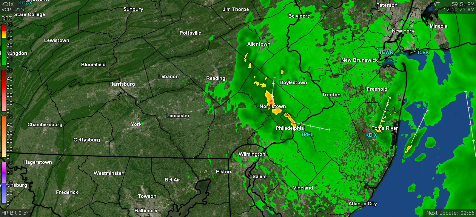
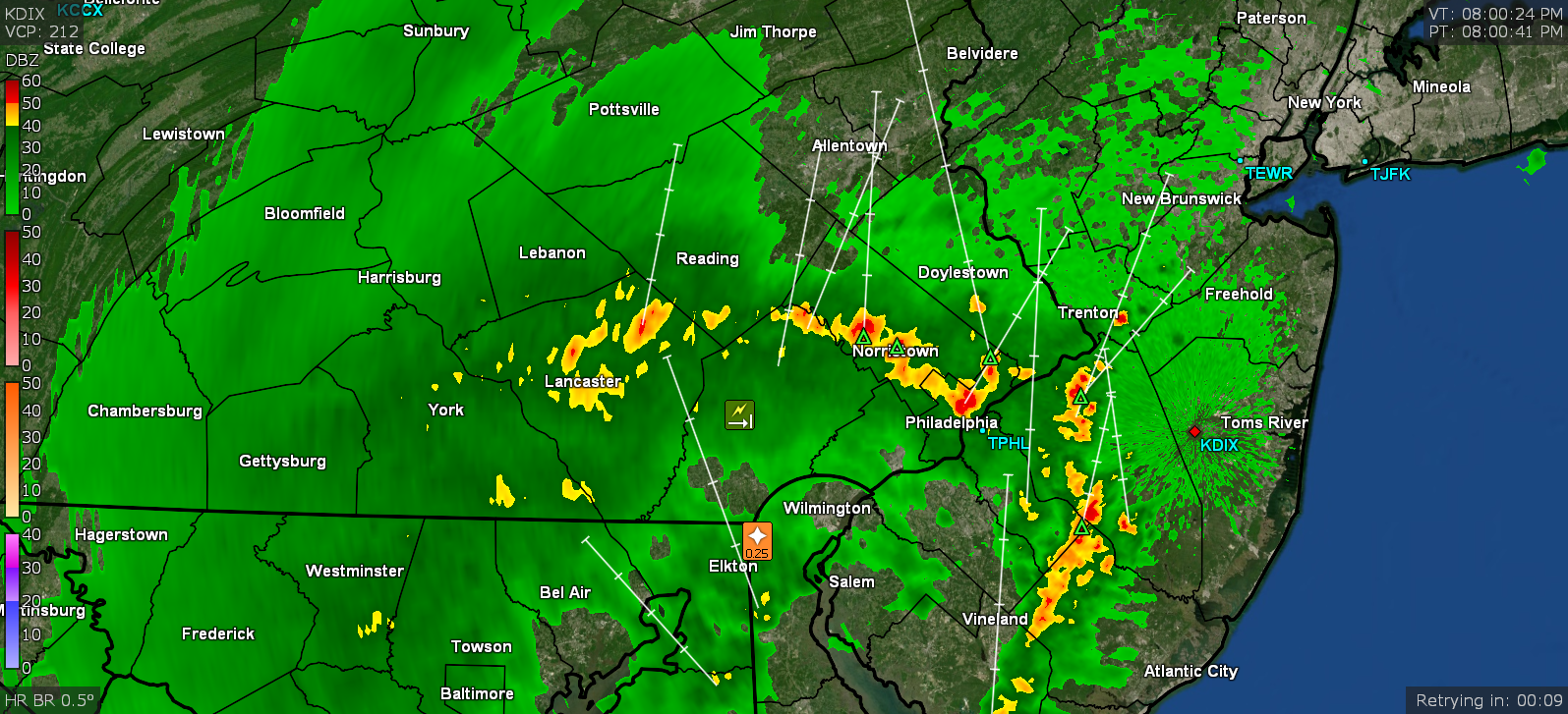
I was watching that wild scene too and grabbed a snapshot earlier today. I ended up hitting 64 just after 12:30 pm and then the temps took a dive mid-afternoon as a band pivoted around and deposited another 0.08" in the bucket for a total of 1.28" for the day so far (2.05" 2-day event total). The sun attempted to peep out earlier this morning and provided a little drying, but then failed to break through much of the rest of the day here. Currently 54 and overcast, with dp 50 and what looks like a broken band now pushing precip out of the NW.
-
Before the rain band pivoted away, I ended up with 1.20" for today and 1.97" for the 2-day event total (so far). Bottomed out at 57 just before 9:30 this morning and it's currently overcast and 61 with dp 59.
-
Ended up with 0.77" of rain yesterday and currently have an additional 1.04" for today (for a 1.81" event total so far at post time). Currently 60 with dp 60 and breezy with light rain.
-
Over 1"/hr rain from that band. It's moving pretty quickly. Temp 63 with dp 61 and 0.21" in the bucket at post time.