Hurricane Agnes
-
Posts
9,264 -
Joined
Content Type
Profiles
Blogs
Forums
American Weather
Media Demo
Store
Gallery
Everything posted by Hurricane Agnes
-
That was back when the Flyers were flying high and would eventually get a pair of Stanley Cups (the first of which I dragged one of my sisters to go see when it was on display downtown). Barry Ashbee ended up getting that eye injury then and was staying right across the alley at what was the old Wills Eye Hospital (which was across from my school at the time). Me and my bunch of nuts buddies would yell out the window to the hospital calling out his name.
-
We did used to have the Philadelphia Soul in the interim (although that indoor league went away right before the pandemic hit in 2019).
-
E PA/NJ/DE Spring 2022 OBS Thread
Hurricane Agnes replied to Hurricane Agnes's topic in Philadelphia Region
Made it up to 61 today and it was an overall nice day. Currently partly cloudy and 59 with dp 40. I hate auto-correct but have found that Apple's auto-correct butchers words far worse than Android. -
E PA/NJ/DE Spring 2022 OBS Thread
Hurricane Agnes replied to Hurricane Agnes's topic in Philadelphia Region
Looks like I bottomed out at 37 and that only happened about an hour ago as there was only a brief period between ~3 am - 4 am when the winds went calm but the rest of the time, there were puffs of breeze to keep things mixed. Currently mostly sunny and 41 with dp 29. -
E PA/NJ/DE Spring 2022 OBS Thread
Hurricane Agnes replied to Hurricane Agnes's topic in Philadelphia Region
After a low of 40 this morning, I did make it up to 52 and the day has definitely been unsettled although much of the time, the sun was out until late in the afternoon. Currently mostly cloudy and 47 with dp down to 28. -
E PA/NJ/DE Spring 2022 OBS Thread
Hurricane Agnes replied to Hurricane Agnes's topic in Philadelphia Region
One of those popcorn storms came through here but only wet the sidewalk a bit (not enough to be measurable). If nothing else manages to tip the bucket, I so far registered 0.43" for the day (and 4.81" for the month so far). My high did make it to 56 around 2 pm and it's currently 49 with dp 41 and ever-changing skies as we close in on sunset. -
E PA/NJ/DE Spring 2022 OBS Thread
Hurricane Agnes replied to Hurricane Agnes's topic in Philadelphia Region
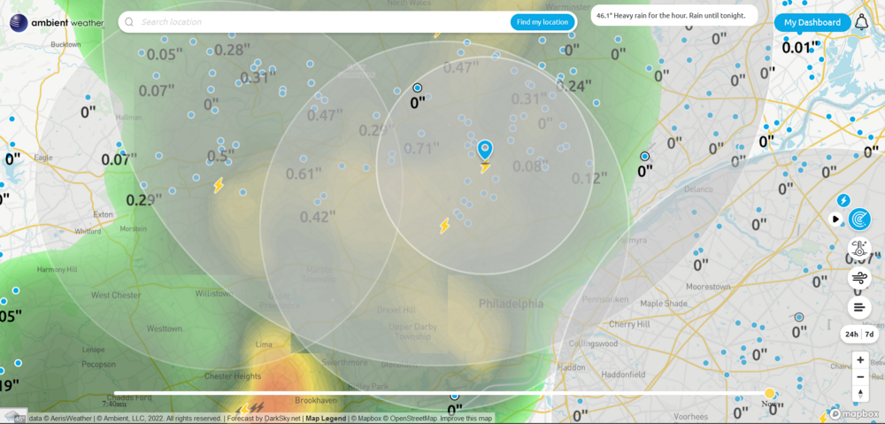
April showers bring May flo... floods? Currently getting a heavy shower (1/3 - 1/2" per hr rates), and with the lighter rain earlier this morning, currently have 0.41" in the bucket at post time. Am now at 4.79" for the month so far and not even past the 2nd week. Current temp is 43 after briefly hitting 48 before the heavier rain came in, with a dp of 42 -
I think because many of us were still getting snow after the end of the met winter, there may have been a desire to hold...out...just...a...little...bit...longer! There were instances where some of us were getting more during storms in March than those in December. In any case, I got 15.62" between November 1st and March 31 (13.57" of that in D-J-F). My 2 biggest events were 1/7/22 (4.50") and 1/29/22 (4.75").
-
E PA/NJ/DE Spring 2022 OBS Thread
Hurricane Agnes replied to Hurricane Agnes's topic in Philadelphia Region
Finished up with 2.55" of rain for Thursday (and 3.93" for the 3-day event). After a low of 45 yesterday, had high of 55 just after 7 pm last night. Currently 44 with dp 44 and damp. -
E PA/NJ/DE Spring 2022 OBS Thread
Hurricane Agnes replied to Hurricane Agnes's topic in Philadelphia Region
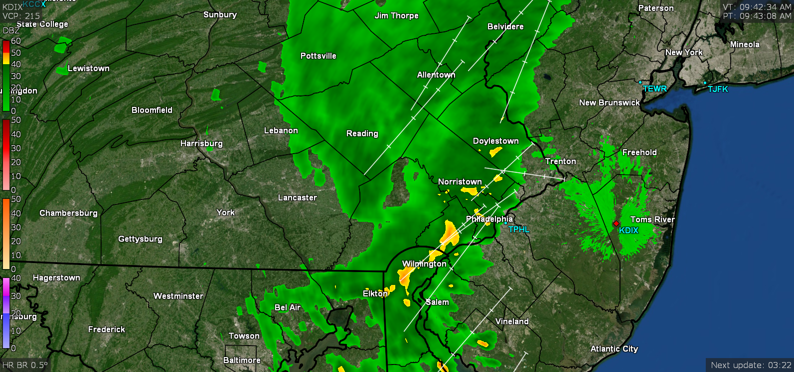
Flood Warning issued for the Schuylkill in Montco - Now up to 2.47" for the day (3.85" for 3 days) and am getting close to the monthly normal in just 1 week! Current temp is 49 with dp 48, and light rain/drizzle/mist. -
E PA/NJ/DE Spring 2022 OBS Thread
Hurricane Agnes replied to Hurricane Agnes's topic in Philadelphia Region
WPC's 5 pm update had penciled in our area for this heavy rain - Up here in my area (although this guage is about 5 miles south of me), the Wissahickon (at the mouth to the Schuylkill) is probably getting close to bankfull - -
E PA/NJ/DE Spring 2022 OBS Thread
Hurricane Agnes replied to Hurricane Agnes's topic in Philadelphia Region
Now over 2.12" for the day (3.50" over 3 days). Temp holding at 49 with dp 49 and currently moderate rain. -
E PA/NJ/DE Spring 2022 OBS Thread
Hurricane Agnes replied to Hurricane Agnes's topic in Philadelphia Region
Now in a little pause. Have 1.91" for the day (3.29" for the 3 days). Temp down to 49 with dp 49. Flood Advisory was expanded and extended -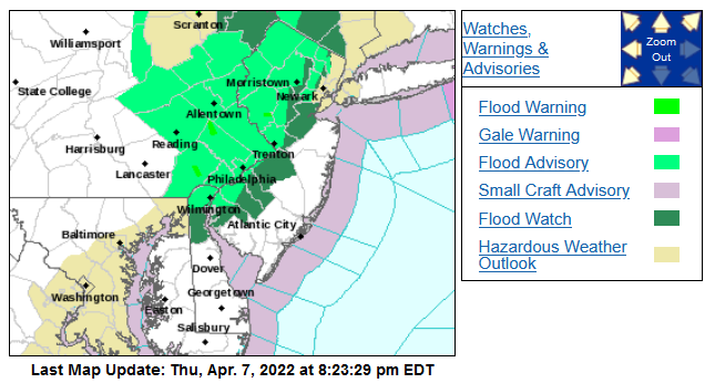
-
E PA/NJ/DE Spring 2022 OBS Thread
Hurricane Agnes replied to Hurricane Agnes's topic in Philadelphia Region
Almost 1 1/4" per hr rates (peaking at almost 2"/hr). Now up to 1.75" for the day (3.13" for the 3 days). Temp back down to 52 with dp 51. -
E PA/NJ/DE Spring 2022 OBS Thread
Hurricane Agnes replied to Hurricane Agnes's topic in Philadelphia Region
Getting absolutely rocked here!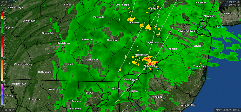
-
E PA/NJ/DE Spring 2022 OBS Thread
Hurricane Agnes replied to Hurricane Agnes's topic in Philadelphia Region
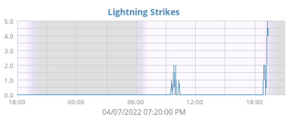
Real loud claps of thunder and getting some convection in the area. Currently up to 1.46" with a heavy downpour. Temp still going up and at 55, dp 55. -
E PA/NJ/DE Spring 2022 OBS Thread
Hurricane Agnes replied to Hurricane Agnes's topic in Philadelphia Region
I think it's about done here too. Now up to 1.21" for the day (so far) which is 2.59" over 3 days and 2.99" for the first week (and month) of April. Temp has crept up to 51 with dp 50 and light rain. -
E PA/NJ/DE Spring 2022 OBS Thread
Hurricane Agnes replied to Hurricane Agnes's topic in Philadelphia Region
Long discussion on that here (small excerpt below) - https://www.severe-weather.eu/global-weather/april-forecast-weather-pattern-polar-vortex-collapse-jet-stream-usa-europe-fa/ -
E PA/NJ/DE Spring 2022 OBS Thread
Hurricane Agnes replied to Hurricane Agnes's topic in Philadelphia Region
As an obs, currently hae 0.80" in the bucket and it's currently misty with occasional drizzle, and 46 with dp 46. -
E PA/NJ/DE Spring 2022 OBS Thread
Hurricane Agnes replied to Hurricane Agnes's topic in Philadelphia Region
Flood Watch for the area issued - Also including the Flood Advisory issued a bit less than 2 hours ago - -
E PA/NJ/DE Spring 2022 OBS Thread
Hurricane Agnes replied to Hurricane Agnes's topic in Philadelphia Region
Have been getting a gully washer storm upwards of an inch/hour rates. Currently have 0.61" in the bucket so far. NWS bot syndicator retweeted from Mt. Holly with the Flood Advisory -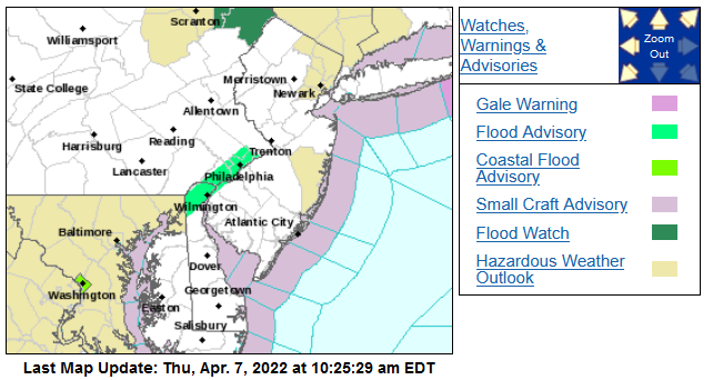
-
E PA/NJ/DE Spring 2022 OBS Thread
Hurricane Agnes replied to Hurricane Agnes's topic in Philadelphia Region
Just had some convection (lightning and thunder). It has been lightly raining for a bit but am now getting heavier rain. Currently 45 with dp 45.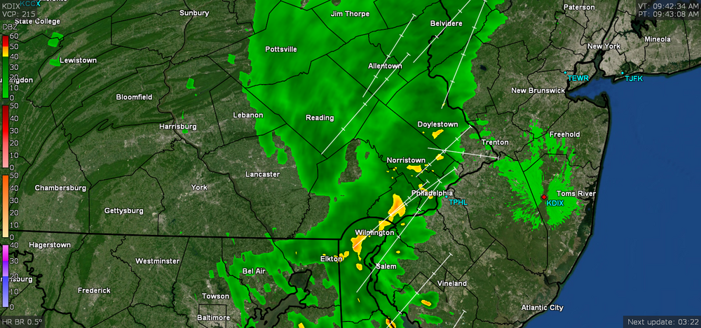
-
E PA/NJ/DE Spring 2022 OBS Thread
Hurricane Agnes replied to Hurricane Agnes's topic in Philadelphia Region
I know Mt. Holly AFD's have been mentioning this the past couple days but SPC has some "Marginal Risk" in the southern part of the CWA, now in SWDY1 - Meanwhile it's currently 45 and overcast/misty here with dp 45. -
Will be great to hear more from you then whenever you get chance!!!
-
E PA/NJ/DE Spring 2022 OBS Thread
Hurricane Agnes replied to Hurricane Agnes's topic in Philadelphia Region
Ended up with 1.23" with this round making for a 1.38" 2-day event total. Currently overcast, misty, and 52 with dp 50.