Iceresistance
-
Posts
4,190 -
Joined
-
Last visited
Content Type
Profiles
Blogs
Forums
American Weather
Media Demo
Store
Gallery
Everything posted by Iceresistance
-

Julia | 85 mph 982 mb peak | EPAC Crossover #2
Iceresistance replied to Iceresistance's topic in Tropical Headquarters
You're not Hurricane Mike -
Julia | 85 mph 982 mb peak | EPAC Crossover #2
Iceresistance replied to Iceresistance's topic in Tropical Headquarters
Thanks for updating it to TD 13 @Scott747, I've come back and done the rest. Best Track has this as Julia, but can't change it to that until the NHC advisory confirms it as TS Julia -
Julia | 85 mph 982 mb peak | EPAC Crossover #2
Iceresistance replied to Iceresistance's topic in Tropical Headquarters
Chances still getting higher, 60/80% -
Julia | 85 mph 982 mb peak | EPAC Crossover #2
Iceresistance replied to Iceresistance's topic in Tropical Headquarters
I swear the accuracy of ASCAT is worse than a Star Wars Stormtrooper. -
Julia | 85 mph 982 mb peak | EPAC Crossover #2
Iceresistance replied to Iceresistance's topic in Tropical Headquarters
Lots of Dry air in the Northern GoM right now, which is why it's very hostile to Tropical Cyclones. -
Julia | 85 mph 982 mb peak | EPAC Crossover #2
Iceresistance replied to Iceresistance's topic in Tropical Headquarters
I'm thinking more westward than northward component because the Hurricane Season in the Gulf of Mexico is possibly over (Can't call it over yet). My general idea is like Ian's track except for more westward after getting closer to Cuba. -
Julia | 85 mph 982 mb peak | EPAC Crossover #2
Iceresistance replied to Iceresistance's topic in Tropical Headquarters
The OP models generally want to have none of this, which is leading me to suggest that we may have spotted a sleeper system. -
Julia | 85 mph 982 mb peak | EPAC Crossover #2
Iceresistance replied to Iceresistance's topic in Tropical Headquarters
Yes, it is now 91L -
Julia | 85 mph 982 mb peak | EPAC Crossover #2
Iceresistance replied to Iceresistance's topic in Tropical Headquarters
This system may have strong outflow already! -
2022 Atlantic hurricane season whining/banter
Iceresistance replied to GaWx's topic in Tropical Headquarters
In a different forum, I did not clarify, and I am more active in different forums compared to here. -
2022 Atlantic hurricane season whining/banter
Iceresistance replied to GaWx's topic in Tropical Headquarters
We all thought that 2022 would be like 2013 all over again, boy we were so wrong. My other weather forum did 2013 comparisons until Earl/Fiona/Gaston/Hermine/Ian combo came and produced over 60 ACE combined! -
Julia | 85 mph 982 mb peak | EPAC Crossover #2
Iceresistance posted a topic in Tropical Headquarters
(I won't be here very much, if one of the mods/admins can change the title for me when I'm gone for updates, that would be very helpful for me. ) The NHC now has an AOI in the Central Atlantic that may develop in the Eastern Caribbean, this could be another monster in the Caribbean. Where it will go exactly is a different question. The Ensembles have this storm into Central America or Florida, again. I'm personally thinking that we could have an absolute beast in the Caribbean again, but this time. The peak intensity appears to be in the Caribbean. There is no Cold-Water Trail left by Ian, OHC is still really high in the Western Caribbean. Wind Shear is low in the Caribbean (It was higher by Fiona's outflow when Ian first formed) Very little to no Dry Air or SAL -
This storm has the potential to become an absolute monster, wind shear is already relaxing and the structure is improving on satellite. I find it wild that it formed under 30-40 knots of Wind Shear, which means that this system is determined to become a BEAST! @Akeem the African Dream and all Florida members, please keep a very close eye on this. Could have the strongest landfall in that part of the state since Irma 2017.
-
Climate Prediction Center's Outlook on Winter 2020-2021, especially in February.
-
Possible sign-up issue?
Iceresistance replied to CheeselandSkies's topic in Forum Information & Help
I have no issue signing up, it probably needs a e-mail confirmation from the admins. -
Possible sign-up issue?
Iceresistance replied to CheeselandSkies's topic in Forum Information & Help
I don’t have issues, maybe it’s certain devices becoming incompatible to be able to do it? -
NWS Fort Worh asked them for a verification, like @*IndyMeso* did. But this is not the biggest ever confirmed, the Texas state record is 6.4 inches near Hondo in April 2022, Burkburnette had 6 inch hail in 2020.
-
5.5 inch hail has been confirmed in Salado, TX
-
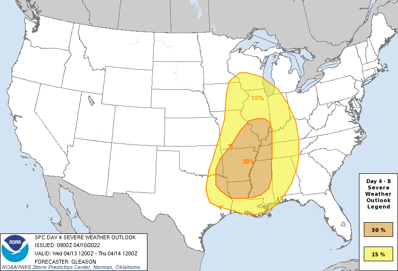
Iowa is at the Triple Point again, highest forcing & could get yet ANOTHER Moderate risk there if the Mesoscale models keep going like the 12z HRRR did to Iowa
-
Maybe Arkansas & SE Oklahoma
-
Did initiate in Southern Oklahoma & Northern Texas
-
Local met from KFOR
-
You beat me to it by an hour!
-
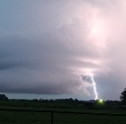
This must be one of the largest Enhanced risks I've ever seen!
-
Snowiest place on earth
Iceresistance replied to LongBeachSurfFreak's topic in Weather Forecasting and Discussion
Japan has Ocean-effect snow, they get a LOT of snowfall every winter


