George001
-
Posts
6,983 -
Joined
-
Last visited
Content Type
Profiles
Blogs
Forums
American Weather
Media Demo
Store
Gallery
Everything posted by George001
-
The ACE is going to probably end up over 200 this year when all is said and done. This hurricane season has been historic.
-
The thing is, the epic 2014-2015 winter dumped 100+ inches of snow in the Boston area AFTER Jan 25th. In the epic 2010-2011 winter by mid Jan Boston already had around 50 inches of snow. Both those winters as epic as they were wasted half the winter, in my opinion the ceiling is something like dec- late Jan 2010-2011 the first half of winter, late Jan to late Feb 2014-2015, and then March 2018 all in one year. I do believe there is a very real chance we get that this winter with how the Enso, polar vortex, and ssts are looking right now. If we do get that, that would be well over 150 inches of snow in the Boston area.
-
This is very interesting, the polar vortex is forecasted to be the weakest we have seen in years. Last year, we had a severe polar vortex event in late dec, and severe North Atlantic blocking developed and stayed in place from early Jan to mid Feb, then the pattern broke down and we had a milder regime from then until early- mid April, too late for a return to winter (we had nice storm where I forecasted a massive blizzard for all of eastern mass in mid April, but the temps were just too warm and the snow did not accumulate. I forecasted 2 feet for my area, got a dusting). This year it looks like we could see a polar vortex event as early as mid-late November if the models are correct, which makes me think we could have our first window of North Atlantic blocking from early December to mid Jan. The pattern then probably starts to break down leading to less North Atlantic blocking from late Jan to early March. It is very possible we see a thaw during that timeframe if the polar vortex does not cooperate. After the North Atlantic blocking regime breaks down, it will have done its job enough to force the polar vortex south, leading to a polar vortex intrusion during the second half of the first blocking regime to a couple weeks after. That probably sets in from late Dec to early Feb. If this window is accurate, the second half of Feb is probably going to suck (similar to 2017-2018). March is where things get really interesting, due to the timing of our polar vortex event, like 2018 while we are in a sucky late Feb pattern there will probably be enough time for another polar vortex event to occur, leading to the development of North Atlantic blocking throughout the entire month of March and into mid April. This is not a guarantee, but due to our winter thaw being from mid Jan-late Feb instead of mid Feb-mid March, that opens up a second window in March (like 2018) rather than last winter. That is the biggest difference between the 2017-2018 winter and last year, what happened in March. what I am thinking we could see right now: biggest windows (2010-2011 type potential due to blocking and a polar vortex intrusion at the same time) : late Dec-mid Jan, early March- late March other windows (high variance, could be epic could suck, really I have no idea yet. What I will try to figure out before my winter forecast in November): early Dec-late Dec, mid Jan-early Feb Will likely suck: mid-late Feb The biggest question for me looking at the models is will the polar vortex cooperate, or will it displace too far west? If it displaces too far west, the mid Jan- early feb window will probably suck due to lack of blocking and a trough in the west. If everything comes together, there is a real chance that we only have a hostile pattern for 2 weeks throughout the entire winter. If nothing breaks our way with the polar vortex, we still have early Dec-mid Jan and then another shot in March, with a 1 month period of suck from late Jan-late Feb. That is our floor in my opinion, and that can still be a damn good winter. The 2017-2018 winter we had a month of suck in Feb. The 2012-2013 winter we had a month of suck in Jan, and the 2014-2015 and 2010-2011 winters we had at least a month of suck (2014-2015 was a month and a half of suck Dec to mid Jan, and 2010-2011 was 2 months of suck Feb-Mar). 2010-2011 in particular we wasted half the damn winter and still got 80 inches of snow in Boston. 2014-2015 we wasted the first half of winter and got hammered the second half. I see 2 good windows at least, which is not something that could be said about 2019-2020 or 2011-2012.
-
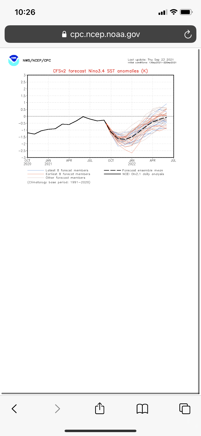
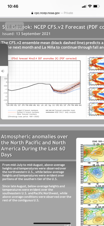
The CFSv2 has the coldest anomalies in the enso 3.4 and enso 3 regions, with less cold in the enso 4 and 1.2 regions. this is what it has at the peak- enso 4 mean: -.6 enso 3.4 mean: -1.6 enso 3 mean: -1.6 enso 1.2 mean: -.8 strength: strong la nina Not really west based like 2016-2017 but not east based like 2017-2018 either, mixed type for sure. The european guidance has a weaker overall La Niña with a mean of -.5 or so. Somewhere in the middle is likely what we end up seeing, with the La Niña moving to the east some but not enough to be truly east based, and being low end moderate strength (around -1.2 or so) The Nina has been doing a good job at helping cool off the Pacific Ocean, which should help prevent the pacific jet from going crazy. That should prevent a trough from developing in the west.
-
A coupled -3C super Nina with severe North Atlantic blocking and a cooperative polar vortex would be really good in the Boston area in my opinion. Going by just the Enso states to snowfall correlation we have approximately the same average in a strong La Niña as we do in Enso neutral, yet people start panicking when they see a strong Nina in the forecast. Not just the mid Atlantic people, even posters on this board were saying how horrible the upcoming winter pattern would be due to the stronger La Niña (the Nina didn’t even end up being strong like expected, it peaked at moderate). Last winter wasn’t anything special but it wasn’t a ratter like many expected. I never understood the fear of La Niña here in New England, if anything when we get severe North Atlantic blocking I would rather have a Nina. The models as well as the current ocean temps make me thing this coming winter will have severe North Atlantic blocking for at least 2 months from December to March, especially the 1st half of winter. The blocking will be more extreme than last winter in my opinion, it will rival 2009-2010/2010-2011 levels. With that in mind I fully welcome a La Niña and hope that it is strong enough to counteract the blocking enough that storms don’t miss to the south.
-
Yeah northern New England should do well, but southern New England and even NYC should be fine even if the Nina somehow got to -3. The Nina is central based now but based on the subsurface the Nina will likely move east and rapidly strengthen.
-
The strength of the La Niña in the most recent update has increased on every model I looked at, even the ones that were leaning towards a weaker one previously.
-
The cfsv2 is not backing down at all, and is only increasing the strength of the La Niña. The MEAN is a 2010-2011 strength La Nina in the latest update (-1.6 to -1.7 mean), with members ranging from -1.2 to -2.6 (this is the biggest outlier, but there are still a few members below -2). Is this overdone? When looking at the other guidance probably, but with the recent cooling of the subsurface combined with not one member of the cfsv2 having a la nina weaker than low end moderate, I do think the potential for a stronger la nina can’t be ruled out just yet.

-
Maybe in the Berkshires, but the Boston area the ceiling is probably around 150 inches is what I am thinking now. Depending on how the pattern evolves over the next couple of months, that number could increase.
-
I 100% agree with you on the epic potential, though I dont think 1995-1996 is the ceiling. I think the ceiling nov-mid Jan 1995-1996, with a transition to a late Jan to late Feb redux 2014-2015, then a transition to March 2018. The closer we get to winter, the better the signals get. I’m going to hold up on my winter forecast right now, but right now I am leaning towards going big. From what I have read the early signs are favorable for North Atlantic blocking, and a La Niña+ North Atlantic blocking pattern makes me lean towards a similar winter to last year being the floor. Last year the pacific was absolute garbage, the polar vortex didn’t cooperate at all, and there was a massive trough in the west. On top of that with individual storms everything that could go wrong did go wrong.
-
Severe North Atlantic blocking with a -.8 weak nina? If we get that we could see the biggest winter since 2014-2015. I hope we get a bunch of Miller B blizzards this year, the way things have been trending I am thinking the ceiling for this winter is extremely high and is increasing the closer to winter we get. Ceiling wise what do you think this upcoming winter can be? When you are talking about a more basin wide rather than west based high end weak nina with severe North Atlantic blocking, I’m thinking 1995-1996 is entering the discussion, possibly even better. Imagine if we get a 1995-1996 start to the season, then from late Jan to late Feb we a get 2014-2015 type pattern when the blocking starts to break down due to a timely polar vortex intrusion. That is the ceiling in my opinion. Due to the cooler waters in the eastern Enso region, the pacific jet shouldn’t be able to strengthen as much, and with the Nina being more basin wide rather than central based, I am starting to think we might not see a trough in the west at all.
-
If you get the same pattern but with a less expansive Hadley cell and a weaker pacific jet I do believe that it would deliver several blizzards to eastern mass. Not just one or two, but 4+. The polar vortex was just a little bit too far west. I could be wrong but it just feels like if we had last years pattern 10 years in a row 9/10 of them would have 60+ inches in the Boston area with all the North Atlantic blocking we got. I just wish the goddamn Hadley cell would go away, it’s making our winters awful.
-
I have been seeing a lot of talk about the upcoming winter pattern possibly being similar to last year, and honestly I don’t hate that. Last year we had some bad luck with a decent pattern late Jan through mid feb and one in December. A lot of close misses, a massive ocean low missed to the south in late Jan, one in early March, early Feb missed a 2 ft+ blizzard by about 20 miles, ect. If we can get last years pattern with a weaker pacific jet and maybe a little less blocking, with a more favorable polar vortex intrusion that could lead to a big winter.
-
An entire seasons worth of snow in one storm, a blizzard of that magnitude would be the most severe blizzard on record. If you take the most severe blizzard I have ever experienced in my life (Feb 2013) and double that, you get a 48-60 inch blizzard. That seems like it would be extremely difficult to do, maybe if you get the early Jan 2018 blizzard (about 14-18 inches eastern mass) with severe North Atlantic blocking to slow it down. The strength of that low got all the way down to the 950 mb, but due to the lack of North Atlantic blocking it didn’t really stall much. Just 2 months later we had a slightly “weaker” low come up the coast in the 960s, yet I ended up with 2 feet of snow from that blizzard. Some areas got close to 3 feet. Imagine if we got a rapidly strengthening 930s mb low that just sat there right over the cape, if we get that I don’t think it’s out of the question that my area ends up getting enough snow that it piles up over my head from that blizzard alone.
-
I think it is very possible we see North Atlantic blocking the entire winter, and even if we don’t there is a good chance we get severe polar vortex intrusions to offset that, as the polar vortex is looking weak on the models.
-
Great write up, I hope it’s wrong in my area but it looks to me like many of your analogs have a trough in the west, which is a legitimate concern. I had some similar analogs (I had 2017-2018 and 2020-2021) but I am learning towards well above average snowfall in my area rather than 87% of normal like yours. It very well could just be me having weenie goggles on, but I did see several of the models saying the polar vortex would be weak and displaced, so I am thinking that could tilt things in our favor some. Just wondering, for that 87% figure are you thinking a more boom or bust winter with a slight lean towards the bust side (hence the 2001-2002 analog), or is it less bust potential and more of a limited ceiling that brought you to forecast slightly below avg snow for my area?
-
I agree, the acceleration of climate change is making our winters warmer. I never saw 70s and even 80s in Feb and March until a few years ago. Snow wise we haven’t started declining yet, but the mid Atlantic has and as the average temperature continues to increase, in my opinion our snow average will decrease as well. There comes a point where the increased upside due to the clashing of a cold airmass with climate change induced warm ocean temps isn’t enough to make up for all the marginal events that would have been snow 20 years ago being rain today. Even in the last 10 years it feels like it’s harder to maintain a snowpack than it was then, even in our above average winters like 2018.
-
I don’t see a trough in the west and despite the lack of North Atlantic blocking it does look like the model is indicating a severe polar vortex intrusion into the eastern United States. For a mean that’s not bad, could be 2 good months 1 bad like 2017-2018. Idk if I’m reading it wrong but it looks like there is a weak El Niño in the Enzo region which is strange.
-
Over recent weeks, the strength of the upcoming La Niña has increased on the models. There is still a decent spread with the CFS going borderline strong where as the European model is going with a weak La Niña. What ends up happening will likely be somewhere in the middle based on what I have been looking at in my opinion. More importantly, the entire Pacific Ocean is cooling off and the models are forecasting a weak and displaced polar vortex, with several intrusions into the eastern United States. Moderate La Niña, severe polar vortex intrusions into the eastern United States, North Atlantic blocking, and a weakened pacific jet is what I am thinking we get for the winter pattern at least the 1st half of winter. Often in the second half of La Niña winters they start to suck on the eastern us because the La Niña weakens and it’s grip on the pattern starts to loosen. This allows the pacific jet to start acting up with limited northern branch interaction due to a stronger and more consolidated polar vortex parked right over the North Pole. In my opinion the floor for this winter is 40 inches in the Boston area, with the strength of the La Niña and the polar vortex being the deciding factors on whether winter peters out early like last year, or whether it goes deep into March with multiple severe blizzards during the back half of winter. The range of outcomes I would say is last year as the floor and 1995-1996 as the ceiling, with 2017-2018 being a most likely middle ground.
-
La Niña probably won’t be strong like I originally thought though since the ocean warmed after cooling to -.9, it’s only -.3 right now and most strong ninas are already at least moderate strength by now. For the 2010-2011 extreme La Niña event the Nina was already strong by this time in the fall of 2010. With the newest data I’d lean low end moderate rather than strong due to the current surface temperatures in the Enso region.
-
Latest cfsv2 data moved towards a stronger La Niña. The mean is around the same strength as last year.
-
That look decent for December but not 2010-2011 like, all that red off the west coast scares me a bit. That tells me that there is a signal for a strong pacific jet as well as a powerful and energized Hadley cell. I don’t really know a lot of Hadley cells but based on what I do know they are not good. I would like to see the Pacific Ocean as a whole cool off to keep the Hadley cell in check. Don’t get me wrong I don’t think that’s a terrible look even with the rough February but it doesn’t scream epic winter, more like an average winter like last year, with the potential being capped due to the expansive Hadley cell. We have had 6 straight winters with an expansive Hadley cell, and I’ll start getting excited for an epic winter when I see signs that the dominance of the Hadley cell this winter won’t be there like it was the last 6.
-
It is? I thought the trough out west was bad. Even Metfan starts to panic when he sees a trough in the west. When Metfan is panicking that’s usually not a good sign, as like me and James (rip) he has snow goggles and tends to be too aggressive with his forecasts. My concern is that with the trough in the west and the strong pacific jet that the pattern would be really zonal, with ceiling being a 6-12 inch storm if everything lines up. I am looking for a severe winter with at least 3-4 massive blizzards like 2010-2011, 2014-2015, ect.
-
Hopefully the strength of the La Niña continues to increase. The entire Pacific Ocean is too warm and we need a decent strength nina to cool it off, limiting the pacific Jets ability to strengthen. The good news is that in the most recent update of the cfsv2 model, there is much less spread than even just a couple weeks ago. This indicates that the picture of what the Enso state will look like in the winter is becoming more clear, with the cluster being narrowed from -.5 to -1.8/-2.0 to -.8 to -1.3, with the mean being right -1.1, a low end moderate. The subsurface also indicates that the structure of the la nina could shift from a western based Nina to a basin wide or even a more eastern based la nina. A high end weak or low end moderate basin wide or east based La Niña would be very favorable for New England blizzards, so hopefully the models are right about that.
-
Yikes that’s not a good look. That ridge in the northern Pacific Ocean is way too far west. It does look like there is a signal for a polar vortex event, but with the polar vortex intrusion being west like last year. North Atlantic blocking is also limited, which combined with the awful pacific would be a disaster.