

Mount Joy Snowman
-
Posts
4,794 -
Joined
-
Last visited
Content Type
Profiles
Blogs
Forums
American Weather
Media Demo
Store
Gallery
Everything posted by Mount Joy Snowman
-

Central PA Winter 2024/2025
Mount Joy Snowman replied to Voyager's topic in Upstate New York/Pennsylvania
He’s stealing your thunder! Now you’ve just got to steal some of his forecasting thunder ha. -
Central PA Winter 2024/2025
Mount Joy Snowman replied to Voyager's topic in Upstate New York/Pennsylvania
He really does. Hey, I saw some flurries here in Harrisburg over lunch. Small victories. -
Central PA Winter 2024/2025
Mount Joy Snowman replied to Voyager's topic in Upstate New York/Pennsylvania
It's not just the negativity; it's that I oftentimes need my decoder ring to decipher what he's saying haha. -
Central PA Winter 2024/2025
Mount Joy Snowman replied to Voyager's topic in Upstate New York/Pennsylvania
24 when I left the house. Winds are just brutal. Ruh-roh nobody posted 0z’s. Hope it doesn’t mean what I think it does. -
Central PA Winter 2024/2025
Mount Joy Snowman replied to Voyager's topic in Upstate New York/Pennsylvania
They are unknowingly related. Interpret that how you'd like -
Central PA Winter 2024/2025
Mount Joy Snowman replied to Voyager's topic in Upstate New York/Pennsylvania
Not many noticeable changes on the 12z GFS, with the LSV still on the western periphery. Storm development and track pretty similar to prior runs. -
Central PA Winter 2024/2025
Mount Joy Snowman replied to Voyager's topic in Upstate New York/Pennsylvania
Let's just say my boss knows not to bother me too much Friday morning haha. -
Central PA Winter 2024/2025
Mount Joy Snowman replied to Voyager's topic in Upstate New York/Pennsylvania
Yeah, you guys did better than us Lancaster folk with that one. I only had 2.3", as the snow switched to sleet and then copious rain, totaling 1.2" QPF. -
Central PA Winter 2024/2025
Mount Joy Snowman replied to Voyager's topic in Upstate New York/Pennsylvania
Low of 17. I received 2.2” of total snowfall off of .19” liquid. This week is just straight winter. -
Central PA Winter 2024/2025
Mount Joy Snowman replied to Voyager's topic in Upstate New York/Pennsylvania
I have to round up to get to that over here. Kept waiting for legitimate flakeage to get here but it was just hours and hours of the type of stuff that barely makes for a coating. All good though, wasn’t expecting this batch to impact us much. Happy for those getting a little refresher. -
Central PA Winter 2024/2025
Mount Joy Snowman replied to Voyager's topic in Upstate New York/Pennsylvania
Nothing I love more than a good Huron connection. Speaking of the Lakes, I don’t think we mentioned in here at all the 60+ inches some places north of Syracuse received this past week. Impressive. I know I mentioned way back liking the southern Tug region but wasn’t sure if we circled back to any actual totals. Also, yes I am aware this is the central PA forum haha. -
Central PA Winter 2024/2025
Mount Joy Snowman replied to Voyager's topic in Upstate New York/Pennsylvania
Looks like MDT reported 2.0" at their 12:56 update. If I'm looking at stuff correctly, they did so off of .14" qpf. -
Central PA Winter 2024/2025
Mount Joy Snowman replied to Voyager's topic in Upstate New York/Pennsylvania
I hope you're right! -
Central PA Winter 2024/2025
Mount Joy Snowman replied to Voyager's topic in Upstate New York/Pennsylvania
I would be thrilled with that. The 18z HRRR still keeps the bulk of what's moving through this evening to our south and west. -
Central PA Winter 2024/2025
Mount Joy Snowman replied to Voyager's topic in Upstate New York/Pennsylvania
Total here is 2.1" as flurries have stopped and skies are brightening a bit. We'll see if we can add anything further this evening. -
Central PA Winter 2024/2025
Mount Joy Snowman replied to Voyager's topic in Upstate New York/Pennsylvania
I have multiple buddies flying into West Palm Beach and then driving down to Miami for the Orange Bowl on Thursday. I reckon they won't have the same issues with snow ha. I decided not to push it with my wife and instead will be watching from the confines of my living room. -
Central PA Winter 2024/2025
Mount Joy Snowman replied to Voyager's topic in Upstate New York/Pennsylvania
Yes, hope indeed. I'm still leaning towards that 500 passage giving the goods to our south. Perhaps some peeps like Bubbler and the gang out there get some extra fluff. I hope to be wrong but I'm thinking we're just going to catch the northern fringe of whatever that brings. These things can have a mind of their own though so we'll see. Hey, I'm happy to see white. -
Central PA Winter 2024/2025
Mount Joy Snowman replied to Voyager's topic in Upstate New York/Pennsylvania
Man, the radar has really collapsed for the LSV, even earlier than I thought it would. Certainly looking like the under is going to easily hit on my 3.5" estimate. -
Central PA Winter 2024/2025
Mount Joy Snowman replied to Voyager's topic in Upstate New York/Pennsylvania
10am Obs: 24/22 with light snow falling and 1.9" of accumulation. -
Central PA Winter 2024/2025
Mount Joy Snowman replied to Voyager's topic in Upstate New York/Pennsylvania
Damn you. Is it coming down good? -
Central PA Winter 2024/2025
Mount Joy Snowman replied to Voyager's topic in Upstate New York/Pennsylvania
I mean, if you would have told me THIS would be the radar this morning, with the northern half of the state absolutely crushing it. Sometimes all you can do is laugh.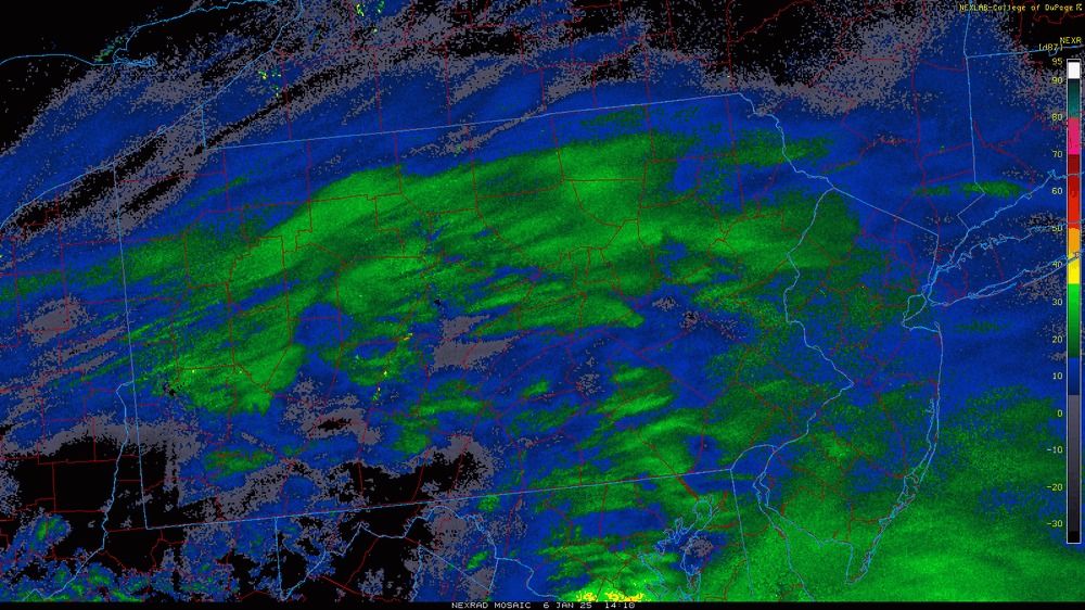
-
Central PA Winter 2024/2025
Mount Joy Snowman replied to Voyager's topic in Upstate New York/Pennsylvania
You see these two wicked bands juuuuust to our north and south right now? I can't quite snag one of those. Still snowing decent. -
Central PA Winter 2024/2025
Mount Joy Snowman replied to Voyager's topic in Upstate New York/Pennsylvania
Saw that. Looks like some better stuff moving in from York County shortly though. I think it's going to be too far south for most of us but hope to be wrong. -
Central PA Winter 2024/2025
Mount Joy Snowman replied to Voyager's topic in Upstate New York/Pennsylvania
Intensity has definitely picked up over here. The next couple hours look to be the goods because I think it's going to shut off pretty quickly for us this afternoon. It really is stunning out there. -
Central PA Winter 2024/2025
Mount Joy Snowman replied to Voyager's topic in Upstate New York/Pennsylvania
23 degrees here and just shy of an inch as light to moderate snowfall seems to be increasing in intensity. What stands out the most to me this morning is that potent band along the route 6 corridor in northern PA. I mean, CTP had basically zero snow forecast for Tioga County. I swear, if those turkeys do better than us with a setup where the main concern was everything being shunted south.....aye. For the record, I do not think they'll score more than us, just surprised to see that on the radar to that extent. Anyway, there's snow falling so happy Monday everyone!


