

Mount Joy Snowman
-
Posts
4,985 -
Joined
-
Last visited
Content Type
Profiles
Blogs
Forums
American Weather
Media Demo
Store
Gallery
Everything posted by Mount Joy Snowman
-

Central PA Summer 2025
Mount Joy Snowman replied to Voyager's topic in Upstate New York/Pennsylvania
Just sat on the porch and watched rounds of T’showers roll through. Shocked it didn’t amount to more given the extreme moisture in the atmosphere and the solid radar returns. Perplexing. In any case, quite the forecast miss today, as I literally had 0% POPs for days on end for this time period. Air is THICK. -
Central PA Summer 2025
Mount Joy Snowman replied to Voyager's topic in Upstate New York/Pennsylvania
Low of 71 here. Had our annual summer party yesterday and while hot, just glad it wasn’t like today or the next few. Got the yard cleanup done early this morning to beat the heat. Brutal out there. Did not expect this much on the radar and at that close of a distance. Interesting. -
Central PA Summer 2025
Mount Joy Snowman replied to Voyager's topic in Upstate New York/Pennsylvania
Haha tell me about it. Normally we wouldn’t go out on a day like that but we had some friends in town from Alaska who really wanted to go on the boat. What’s nice about that long stretch of river is if you have RadarScope and a weather nerd on board you can pretty easily outrun any storms. But generally speaking, we wouldn’t typically be messing around in such conditions. -
Central PA Summer 2025
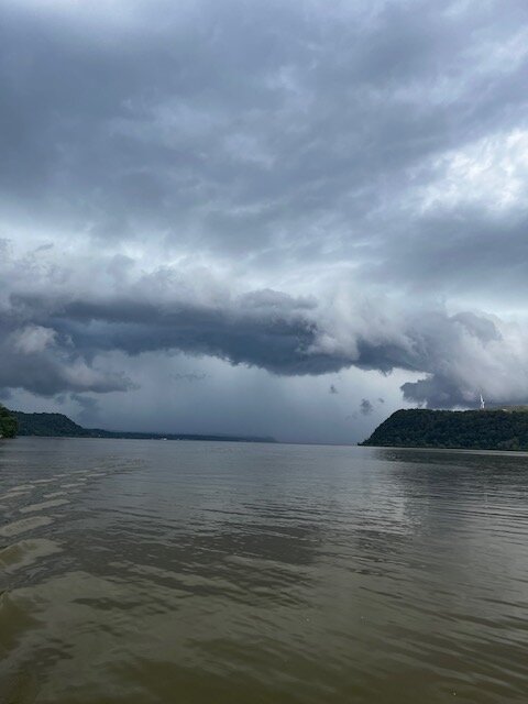
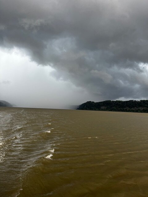
Mount Joy Snowman replied to Voyager's topic in Upstate New York/Pennsylvania
Took some cool pics on the river yesterday while we were dodging storms. Fun stuff.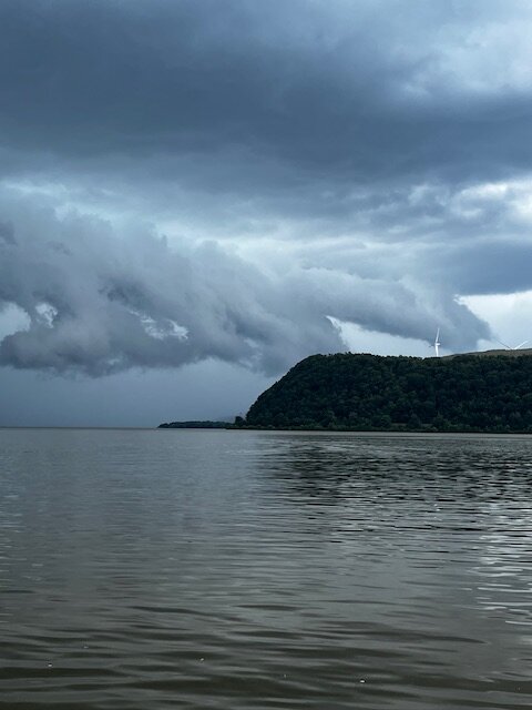
-
Central PA Summer 2025
Mount Joy Snowman replied to Voyager's topic in Upstate New York/Pennsylvania
Low of 60 with .78” of rain. Gorgeous day out there. -
Central PA Summer 2025
Mount Joy Snowman replied to Voyager's topic in Upstate New York/Pennsylvania
That’s kind of what I’m thinking/hoping as well. -
Central PA Summer 2025
Mount Joy Snowman replied to Voyager's topic in Upstate New York/Pennsylvania
Low of 69 with .03” of rain. We’ll be on the river this morning. Probably have to pull out early this afternoon. Keeping a close eye on things. -
Central PA Summer 2025
Mount Joy Snowman replied to Voyager's topic in Upstate New York/Pennsylvania
I had a buddy send me some pics of decent flooding in Manheim. Looks like some spots up there got damn near two inches in a half hour, including a half inch in five minutes at one point. Intense. -
Central PA Summer 2025
Mount Joy Snowman replied to Voyager's topic in Upstate New York/Pennsylvania
Not shabby. Move the decimal one place to the left at that’s about where I’m at. -
Central PA Summer 2025
Mount Joy Snowman replied to Voyager's topic in Upstate New York/Pennsylvania
Everything skirted me all day here. It was wet everywhere when I got off the train in Mount Joy but not far into the drive home the roads quickly became bone dry. Just a couple hundredths at the house. -
Central PA Summer 2025
Mount Joy Snowman replied to Voyager's topic in Upstate New York/Pennsylvania
MDT record highs for 6/23-6/25 are 97, 98, 98. I tend to think there will be a bit too much moisture in the ground for the surface level to break those marks but it could be close. We shall see. -
Central PA Summer 2025
Mount Joy Snowman replied to Voyager's topic in Upstate New York/Pennsylvania
Low of 68 and .18” of precip. Summer has arrived. -
Central PA Summer 2025
Mount Joy Snowman replied to Voyager's topic in Upstate New York/Pennsylvania
KMJS stats: 1.18" since Saturday, 2.19" for the month, and 20.46" YTD. -
Central PA Summer 2025
Mount Joy Snowman replied to Voyager's topic in Upstate New York/Pennsylvania
Low of 63 with a hefty .73” of rainfall. -
Central PA Summer 2025
Mount Joy Snowman replied to Voyager's topic in Upstate New York/Pennsylvania
Much more rain than I was expecting today. The ridge really looks to get pumping during the extended period. Summer on the way. -
Central PA Summer 2025
Mount Joy Snowman replied to Voyager's topic in Upstate New York/Pennsylvania
Low of 58 and .15” of rainfall. -
Central PA Summer 2025
Mount Joy Snowman replied to Voyager's topic in Upstate New York/Pennsylvania
Low of 59 with .3” of rain. Heading out for a little father’s day golf outing here in a bit and it looks like we may actually stay mostly dry. -
Central PA Summer 2025
Mount Joy Snowman replied to Voyager's topic in Upstate New York/Pennsylvania
Low of 65 and no rain here yet. Great day on the boat yesterday but the water was still quite chilly. -
Central PA Summer 2025
Mount Joy Snowman replied to Voyager's topic in Upstate New York/Pennsylvania
Low of 69. Boat day. -
Central PA Summer 2025
Mount Joy Snowman replied to Voyager's topic in Upstate New York/Pennsylvania
Looks like MDT will fall just short of 90. -
Central PA Summer 2025
Mount Joy Snowman replied to Voyager's topic in Upstate New York/Pennsylvania
Haha that's a great story. You seem like a top-notch bartender. I'll have to come in sometime when I can try one of your cocktails. My boss was darn close to ordering an old fashioned and had he done so, I would have quickly followed suit ha. But alas, duty called. Food was outstanding! -
Central PA Summer 2025
Mount Joy Snowman replied to Voyager's topic in Upstate New York/Pennsylvania
Low of 64. I wonder if MDT can make a run at its first 90 of the year today. -
Central PA Summer 2025
Mount Joy Snowman replied to Voyager's topic in Upstate New York/Pennsylvania
A refreshing 59 when I left the house to go along with 24-Hr rainfall of .45”. -
Central PA Summer 2025
Mount Joy Snowman replied to Voyager's topic in Upstate New York/Pennsylvania
Just got lunch at the Cork & Fork and met @Jns2183 for the first time, a great dude! -
Central PA Summer 2025
Mount Joy Snowman replied to Voyager's topic in Upstate New York/Pennsylvania
Yeah I missed out on most of that extreme overnight stuff and then I had left the house prior to that big line hitting this morning. Judging from the WU stations right near me, I picked up an additional ~.5", nothing close to what transpired out your way.
