

Mount Joy Snowman
-
Posts
4,177 -
Joined
-
Last visited
Content Type
Profiles
Blogs
Forums
American Weather
Media Demo
Store
Gallery
Posts posted by Mount Joy Snowman
-
-
Low of 59. Today should mark 11 straight days of negative departures for MDT before things turn around for the foreseeable future tomorrow. Onward.
-
Low of 57. Beautiful Sunday on tap.
-
Low of 59. Another gorgeous day on tap.
-
 1
1
-
-
4 hours ago, ChescoWx said:
With today's high/low splits of 76.0/56.7 we have now recorded our 8th straight below normal day to kick off the month of August. This August is now off to the chilliest start (avg. temp of 67.6) in my 22 years here in East Nantmeal. The prior chilliest was back in 2013 with an average temperature of 68.3
Not sure what the weenie emoji was for on this post, as MDT has also started with a negative departure every day this month.
-
1
-
 1
1
-
-
31 minutes ago, canderson said:
63 was the low. Very smoky still.
Should be clearing out momentarily, visible satellite shows it scouring out quickly. All clear over here with baby blue skies. Low of 57. Boat day!
-
2
-
-
No rain here. Low of 63. A beautiful fews days ahead before things turn bigly muggy again next week.
-
2
-
-
21 minutes ago, canderson said:
Double plus a year!
Ah, a fellow 1982 baby I see! I’ve got you by six and a half months.
-
1
-
-
67/65 when I left the house. Smoke haze was much worse in Harrisburg yesterday, barely noticeable at home.
-
2
-
-
62/59 when I left the house. Solid summer days. Not much to talk about.
-
Low of 58. MDT sitting at a cool 6+ degrees BN through the first three days of the month. Things starting to get warmer but still a nice mid summer week ahead.
-
1
-
-
19 minutes ago, Blizzard of 93 said:
Same here! Perfect night for a Summer fire pit. We enjoyed s’mores and the crisp evening air.
We lied to the kids and told them we were out of marshmallows bc it was late and they were breaking down and we didn’t want to deal with the mess, yada yada. Anyway, it reminded me of this tweet I saw one time that cracked me up, went something to the effect of:
”Me before having kids: I will never lie to my children.
Me today: They don’t sell hotdogs in Colorado.”

-
 2
2
-
-
1 hour ago, canderson said:
54 here. Monday it might actually hit 90. The cool down is being muted for daytime highs but the overnight lows will be nice at least.
Yep. The older I get the more I check dew points over temps, at least in the summer anyway.
-
4
-
 1
1
-
-
Low of 57. Had an awesome fire pit with the kids last night.
-
2
-
-
Low of 56. My weekend is inundated with kids birthday parties. Hoping to find time to make a fire one night.
-
1
-
-
9 hours ago, Jns2183 said:
I thought you might enjoy this. I focused it for Mt Joy. It's the precipitation recurrence interval for different time periods.
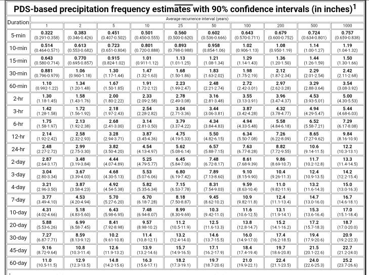
Sent from my SM-X210 using Tapatalk
I can’t get enough of this chart. The values look about what I’d expect them to look like and align pretty well with my own observations. Thanks for sharing!
-
30 minutes ago, canderson said:
Ground is pretty tough - weeded this am and had to use some force to dig.
As you’d imagine, complete opposite here. I weeded earlier and everything pulled right up.
-
6 hours ago, Itstrainingtime said:
@MUweather
Due primarily to oppressively warm nights and a slew of days with highs between 89-95F, #July2025 concluded as the 2nd-hottest on record @millersvilleu since 1914. It was also the 10th-wettest on record thanks to a seemingly endless onslaught of slow-moving, drenching T-storms.
July was my 3rd wettest month ever with 11.51". My YTD is now 39.03" -- only 8.57" of which fell in Jan thru Apr. Each of my last three months have been over 9", amazing.
For MDT, it was "only" the 8th warmest and 21st wettest July on record with 6.15".
-
 1
1
-
-
Low of 65 and 2.09” of rain with a glorious airmass in place. Happy Friday, all.
-
1
-
1
-
-
Cold front blowing through, feels absolutely amazing outside. We deserve this boys!
-
1
-
1
-
1
-
-
6 minutes ago, Voyager said:
I know how they're going to play out. Tamaqua and eastern Schuylkill County will be fringed, as usual.
Wait, I thought you just said you got a half inch?? That's nothing to sneeze at. I know you're being facetious (maybe? haha), but we actually don't know how any of it will play out. Wasn't the best action always supposed to favor southeastern areas today? C'mon, head up Voyager!
-
1
-
-
1 minute ago, Jns2183 said:
Full sun. 89. The dew point has dropped to 71
Sent from my SM-G970U1 using Tapatalk
A buddy of mine is driving to Lake Ontario and he said once he hit New York the temp was 60.
-
3
-
-
14 minutes ago, Itstrainingtime said:
Nary a drop in Maytown...
I've noticed, although that looks to finally be changing. You just never know how or where these events are going to play out.
-
1
-
-
7 minutes ago, Superstorm said:
And so it begins....Flood Warnings have been issued.
Yeah I'm right in the thick of it and the dreaded back-building keeps happening every time I think the back edge is near. Over an inch and a half now. Developing....
-
3
-
-
75/72 here with ~.6" from round one and lots of thunder. Next batch looks to stay primarily to the southeast.
-
2
-
Central PA Summer 2025
in Upstate New York/Pennsylvania
Posted
Low of 68. Perhaps someone gets lucky today with a random pop-up. Much better chance late tomorrow.