

Mount Joy Snowman
-
Posts
4,035 -
Joined
-
Last visited
Content Type
Profiles
Blogs
Forums
American Weather
Media Demo
Store
Gallery
Everything posted by Mount Joy Snowman
-

Central PA Winter 2024/2025
Mount Joy Snowman replied to Voyager's topic in Upstate New York/Pennsylvania
Low of 14. Nothing here but love hearing that some of you woke up to a coating of snow, always a pleasant surprise. -
Central PA Winter 2024/2025
Mount Joy Snowman replied to Voyager's topic in Upstate New York/Pennsylvania
I know my friend, I know. Just razzin ya a bit. Merely lamenting the GFS long range shenanigans, but I would never say we’re done in January. I don’t call curtains until April. I’m a snow junkie. I’ll take it however and whenever. -
Central PA Winter 2024/2025
Mount Joy Snowman replied to Voyager's topic in Upstate New York/Pennsylvania
The GFS showed a monster at 300+ hours!? GET OUT! Bahahaha but I still love ya Blizz -
Central PA Winter 2024/2025
Mount Joy Snowman replied to Voyager's topic in Upstate New York/Pennsylvania
I am indeed, especially my backyard. Hills are always at a disadvantage in that they receive less snow, same amount falling from the sky but has to cover a larger surface area than it would on a flat surface. Think right triangle. North facing slopes are able to more than counteract that loss by getting way less solar wattage. Southern facing hills get double-whammied and can look paltry pretty quick. There's nothing Harrisburg loves more than dumping mounds of salt all around the capitol complex, to the point where we're walking knee deep in the stuff ha, and leaving all the side street sidewalks completely covered. -
Central PA Winter 2024/2025
Mount Joy Snowman replied to Voyager's topic in Upstate New York/Pennsylvania
Indeed, in fact I'm here today too. Just went to Market for lunch. Yes, I would say the pack is a wee bit thicker up this way. Not sure if that would make any difference with regards to temperature, since everything down our way is solidly covered too. I think the frozen river works wonders for the Harrisburg locations and allows a place like MDT to realize its full potential on shallow inversion nights. I mean, it's in about as low of a spot as you can get ha, and has those high ridges around it. The only thing preventing it from going lower on most nights is the river presence. Cover that baby up with ice and that worry is gone. I think it helps cool the city too, don't see how it wouldn't. -
Central PA Winter 2024/2025
Mount Joy Snowman replied to Voyager's topic in Upstate New York/Pennsylvania
Just realized MDT broke the daily record for coldest mean temp yesterday at 5.0 degrees. -
Central PA Winter 2024/2025
Mount Joy Snowman replied to Voyager's topic in Upstate New York/Pennsylvania
If there’s one thing that remains true in this game it’s that predictions made for months out, while better than they used to be, are still virtually impossible. -
Central PA Winter 2024/2025
Mount Joy Snowman replied to Voyager's topic in Upstate New York/Pennsylvania
4 at the house when I left, lowest car thermo reading was -2. I think it’s fair to say this week has been one of the more impressive cold outbreaks of our lifetimes. -
Central PA Winter 2024/2025
Mount Joy Snowman replied to Voyager's topic in Upstate New York/Pennsylvania
I wonder if MDT can keep it close to the min max record of 14 for today? Some PA sites won't be far off from the national low, which was -26 at Clayton Lake, ME. Without doing the necessary research, I'm thinking these are the coldest temps at MDT since the 1994 outbreak. Can anyone confirm? -
Central PA Winter 2024/2025
Mount Joy Snowman replied to Voyager's topic in Upstate New York/Pennsylvania
Yes that's an Amtrak favorite ha. Come to think, they only opened one door this morning, likely the same issue. -
Central PA Winter 2024/2025
Mount Joy Snowman replied to Voyager's topic in Upstate New York/Pennsylvania
Yes I’ve dove into this topic a couple of times over the years. Low spot along a ridge line in a rural area. Have also speculated about what looks to be a quarry or large barren rocky area right next to the airport. At least in the past when I checked on satellite view it showed up prominently. Lack of vegetation is a major component to areas the go anomalously low during inversion nights. -
Central PA Winter 2024/2025
Mount Joy Snowman replied to Voyager's topic in Upstate New York/Pennsylvania
I wait in my car until a couple minutes before it arrives. You can use the app to track. It was running 15 mins late today. Train cars are nice and heated though. Just passed by MDT. The river is more solidly frozen than I’ve seen it in many years. -
Central PA Winter 2024/2025
Mount Joy Snowman replied to Voyager's topic in Upstate New York/Pennsylvania
Zero at my house when I left, will likely go negative. Car thermo hit -11 through low rurals, showing -8 right now at the Mount Joy train station. Wild. -
Central PA Winter 2024/2025
Mount Joy Snowman replied to Voyager's topic in Upstate New York/Pennsylvania
Have not seen a single flake here. -
Central PA Winter 2024/2025
Mount Joy Snowman replied to Voyager's topic in Upstate New York/Pennsylvania
Horst doesn't tweet much anymore but he just said in his 40+ years in the weather business this is the first time he has seen a blizzard warning on the Gulf Coast. -
Central PA Winter 2024/2025
Mount Joy Snowman replied to Voyager's topic in Upstate New York/Pennsylvania
No, other than to confirm what you're saying. Millersville seems to be the unofficial official gatekeeper of Lancaster weather records. -
Central PA Winter 2024/2025
Mount Joy Snowman replied to Voyager's topic in Upstate New York/Pennsylvania
What a scene at Laurel Ridge State Park...... -
Central PA Winter 2024/2025
Mount Joy Snowman replied to Voyager's topic in Upstate New York/Pennsylvania
Low of 4 here. Looks like the lowest temp on CTP's PNS was -20 near Lopez in Sullivan County. Smethport hit -19. This snowpack isn't going anywhere. -
Central PA Winter 2024/2025
Mount Joy Snowman replied to Voyager's topic in Upstate New York/Pennsylvania
Wow!! -
Central PA Winter 2024/2025
Mount Joy Snowman replied to Voyager's topic in Upstate New York/Pennsylvania
Deal! Normally yes but this week I don’t come in until Wednesday. We should barely lose any pack the next few days. -
Central PA Winter 2024/2025
Mount Joy Snowman replied to Voyager's topic in Upstate New York/Pennsylvania
Thought you all might get a kick…..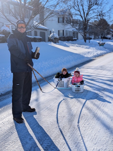
-
Central PA Winter 2024/2025
Mount Joy Snowman replied to Voyager's topic in Upstate New York/Pennsylvania
My 6.8” of snow melted down to .51” liquid, for a ratio of 13.3:1. We had a couple hours up front where nothing was accumulating, so the actual snow that did accumulate was a good bit higher ratio. Had the kids out sledding and shoveling, now have a fire going outside. Nothing better than fire and snow. Great day in the sun. Cheers to American Weather! -
Central PA Winter 2024/2025
Mount Joy Snowman replied to Voyager's topic in Upstate New York/Pennsylvania
Low of 12. Will have qpf from my 6.8” of snow a little later. What a splendid scene out there. -
Central PA Winter 2024/2025
Mount Joy Snowman replied to Voyager's topic in Upstate New York/Pennsylvania
Whiskey Gingers flowing over here. Congrats to the Eagles and Bills. Intense games all the way around. Almost wondering if I didn’t under measure. Looks like more than 7” out there. What a fun storm! Down to 16 already. -
Central PA Winter 2024/2025
Mount Joy Snowman replied to Voyager's topic in Upstate New York/Pennsylvania
Final measurement of 6.8” here in West Hempfield Township. Awesome fast-moving storm today! Have I mentioned I love this winter.


