Mount Joy Snowman
-
Posts
4,964 -
Joined
-
Last visited
Content Type
Profiles
Blogs
Forums
American Weather
Media Demo
Store
Gallery
Everything posted by Mount Joy Snowman
-

Central PA Autumn 2023
Mount Joy Snowman replied to Itstrainingtime's topic in Upstate New York/Pennsylvania
Low of 48 here. We've knocked back the MDT +departure to 3 degrees now and should do a real number on it through the end of the month. In fact, I'll put myself out there and say we end with a mean temp of 69.4, which would put us at only 1.5 AN for the month and alone for 23rd place all time. Pretty remarkable given how the month started. -
Central PA Autumn 2023
Mount Joy Snowman replied to Itstrainingtime's topic in Upstate New York/Pennsylvania
Yeah it is. The meso's are all at long range but every one of them brings the storm west. This would be a major fail for the Euro/Ukie combo. What ever happened to that tandem? They used to be rock solid together, particularly with coastal storms. -
Central PA Autumn 2023
Mount Joy Snowman replied to Itstrainingtime's topic in Upstate New York/Pennsylvania
Yes that is absolutely the case, much of it do to their mocking of certain injuries our guys sustained, and just a general hatred for the Hawkeyes ha. Unfortunately, I don't think a romp is in the cards, mainly due to style of play, weather, a good Hawkeye D, a Penn State O still finding itself, etc. I just want a win, don't care how we get it. This is one of the only whiteouts I will not be attending in person so hopefully that doesn't doom the good guys ha. -
Central PA Autumn 2023
Mount Joy Snowman replied to Itstrainingtime's topic in Upstate New York/Pennsylvania
Low of 50 here. National high of 111 at Rio Grande Village, TX and low of 15 at a place called.......Ketchum, ID. Pretty impressive national low for September. We're getting to that time of year, some blue starting to pop on the models out west. Man, this system is hard to pin down. Seems a bit unpredictable and dare I say disorganized. Down this way, some good rainfall seems like a sure bet but man that forecast for State College is tough. Could be damn near completely dry all day Saturday up there, a total washout, or anything in between. Really tough call for them but hopefully things come into focus here as we get inside of 48 hours. -
Central PA Autumn 2023
Mount Joy Snowman replied to Itstrainingtime's topic in Upstate New York/Pennsylvania
How 'bout it. Regardless of eventual outcome, I plan on mowing on Friday and laying down some fresh grass seed. Plenty of patch work to do with two dogs, one of whom loves to dig ugh. -
Central PA Autumn 2023
Mount Joy Snowman replied to Itstrainingtime's topic in Upstate New York/Pennsylvania
Correct, not serious haha. But thanks for posting anyway! I saw the Ukie. I'm probably one of the few people who still checks that model pretty consistently. I have no idea why ha. -
Central PA Autumn 2023
Mount Joy Snowman replied to Itstrainingtime's topic in Upstate New York/Pennsylvania
How long until the Canadian sobers up? Also, what are the JMA and NAVGEM saying? I demand answers! But seriously, would be quite the coup for our friends up north. -
Central PA Autumn 2023
Mount Joy Snowman replied to Itstrainingtime's topic in Upstate New York/Pennsylvania
51 when I left the house. May have dropped another degree or two after I left. Hit 48 in the car through the rurals. Beautiful crisp morning. River looks pristine from the train. -
Central PA Autumn 2023
Mount Joy Snowman replied to Itstrainingtime's topic in Upstate New York/Pennsylvania
Tell me about it ugh. I was there as well. And yes, Iowa would love nothing more than a bad weather game. Nobody loves making a game ugly more than Iowa. -
Central PA Autumn 2023
Mount Joy Snowman replied to Itstrainingtime's topic in Upstate New York/Pennsylvania
Hey @Itstrainingtime I just saw there was a pretty big explosion out your way near Bossler Road and 743. Seems like propane tanks at a residential unit. -
Central PA Autumn 2023
Mount Joy Snowman replied to Itstrainingtime's topic in Upstate New York/Pennsylvania
Haha yeah somehow I don't think that the dumpster fire that is Northwestern football will present much of a road block this year. Although, they did just announce that it will be the 'ol 11am local kickoff. I've seen many a team show up sleepy in those spots. However, we are now 12-2 all time on our PSU road trips so it's a mortal lock at this point that we bring the winning mojo with us. -
Central PA Autumn 2023
Mount Joy Snowman replied to Itstrainingtime's topic in Upstate New York/Pennsylvania
Ha! No no my friend. While I do have season parking, we are in Lot 12 on the grass. We prefer to rub elbows with the common folk. I always prefer tailgating on grass and we seek out grass lots on all our road trips as well. Less than two weeks until we head out to Evanston! Sneaking in a night in Chicago as well tehe. -
Central PA Autumn 2023
Mount Joy Snowman replied to Itstrainingtime's topic in Upstate New York/Pennsylvania
Only .49" here but still pleased. Looks like another splendid week on tap. I think the weather will be mostly fine for tailgating on Saturday. Call it a hunch. -
Central PA Autumn 2023
Mount Joy Snowman replied to Itstrainingtime's topic in Upstate New York/Pennsylvania
Low of 49 here. Looking forward to a dreary day of football watching. Go Pack! -
Central PA Autumn 2023
Mount Joy Snowman replied to Itstrainingtime's topic in Upstate New York/Pennsylvania
Low of 51. Heading to Oktoberfest with the kids this afternoon. Another A+ day on tap. -
Central PA Autumn 2023
Mount Joy Snowman replied to Itstrainingtime's topic in Upstate New York/Pennsylvania
Low of 47 here, wasn't expecting to go quite that low. Had the windows open all night and house was at 59 this morning. Glorious, although the wife and kids don't think so ha. -
Central PA Autumn 2023
Mount Joy Snowman replied to Itstrainingtime's topic in Upstate New York/Pennsylvania
And so it begins. #WinterIsComing -
Central PA Autumn 2023
Mount Joy Snowman replied to Itstrainingtime's topic in Upstate New York/Pennsylvania
Low of 55 here, and so begins our week-plus stretch of weather perfection. Enjoy, everyone. National high of 108 at Death Valley and low of 24 near Mackay, ID. -
Central PA Autumn 2023
Mount Joy Snowman replied to Itstrainingtime's topic in Upstate New York/Pennsylvania
Howdy Autumn 2023 thread; how do you do? I put one final post on the summer thread regarding the map I posted earlier, for anyone who cares. Here's to football, crisp nights, cool beers, hoodies, colored leaves, and raging fire pits! -
Central PA Summer 2023
Mount Joy Snowman replied to canderson's topic in Upstate New York/Pennsylvania
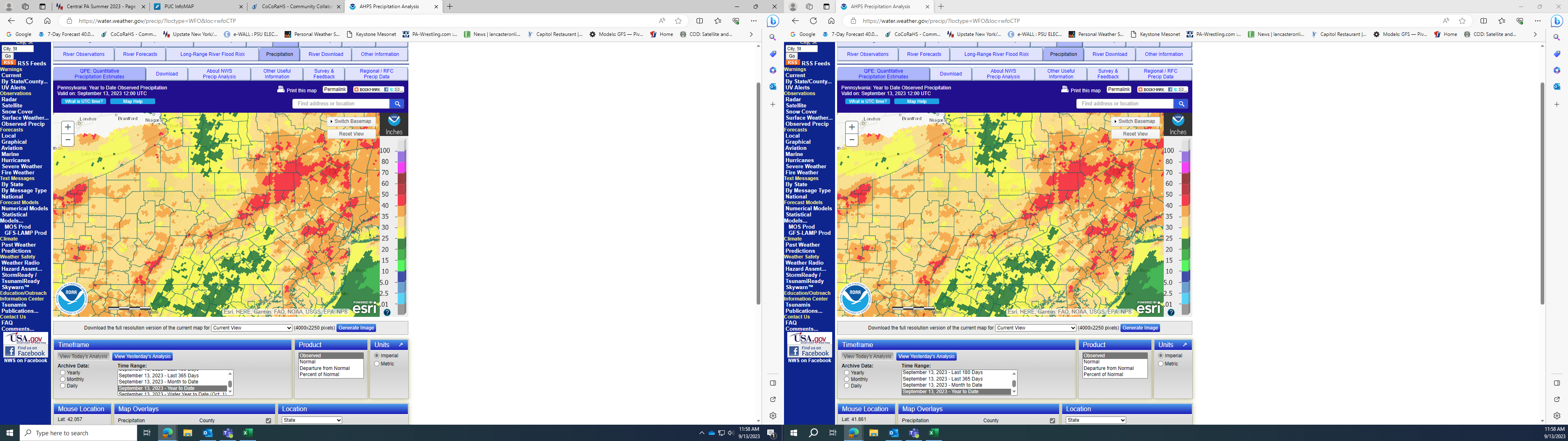
I thought the map was pretty accurate as well, or at least as accurate as these sorts of things can be. Obviously it's smoothed out so you're going to have irregularities, and it will miss some of the smaller geographic outliers but overall, pretty decent. I sit at 23.81" for the year. This is just one of many sources I use but here is the site and a better version of the graphic......I'll move over to the Fall thread now, toodles.... AHPS Precipitation Analysis (weather.gov) -
Central PA Summer 2023
Mount Joy Snowman replied to canderson's topic in Upstate New York/Pennsylvania
MJS reporting for duty. The highest YTD totals on Cocorahs are 48.66" at Hidden Valley in Somerset County and then a couple in the 42-47" range in Northampton Co. When looking at just the people who report consistently, the lowest seems to be a guy near New Oxford with 15.99" and then a few right around 20" in York and Adams Counties. Here is the estimated observed YTD precip in map form, which lines up pretty well with where we know the most/least amounts have been.
-
Central PA Summer 2023
Mount Joy Snowman replied to canderson's topic in Upstate New York/Pennsylvania
Unfortunately, there were still some embedded downpours that my area missed out on. No worries, as I've had enough rain to spring things back to life. In any event, between the rain and cooling temps I'll be mowing again on Friday for the first time in a while. -
Central PA Summer 2023
Mount Joy Snowman replied to canderson's topic in Upstate New York/Pennsylvania
.07” of rain and a low of 68. Looking forward to a new airmass moving into the region today and planting itself here for a bit. Fire pit season is upon us. -
Central PA Summer 2023
Mount Joy Snowman replied to canderson's topic in Upstate New York/Pennsylvania
Hey @Itstrainingtime did you happen to see that the Orioles became the first team in MLB history to beat every other team at least once in a single season. Obviously has only been possible for a small portion of that history but still a cool stat. -
Central PA Summer 2023
Mount Joy Snowman replied to canderson's topic in Upstate New York/Pennsylvania
This is the route I take to PHL, on the rare occasion I've had to fly out of that place. Always try for BWI or MDT when possible.