

TimB
-
Posts
17,206 -
Joined
Content Type
Profiles
Blogs
Forums
American Weather
Media Demo
Store
Gallery
Everything posted by TimB
-

Western PA/Pittsburgh Winter 2021/22 Discussion
TimB replied to meatwad's topic in Upstate New York/Pennsylvania
Jesus, this thread today is virtually unreadable. All I wanted to know was how this clipper worked out while I’m out of town and it looks like this went from basically a non-event when I left on Friday to a solid clipper putting down a couple to maybe a few inches. It’s hard to see how something like this would “bust” unless the ground truth ended up being a coating or something in that range, which it didn’t. -
Western PA/Pittsburgh Winter 2021/22 Discussion
TimB replied to meatwad's topic in Upstate New York/Pennsylvania
Temp has officially made it to 20 at PIT, the 1053rd consecutive day of 20 or higher. Previous record was 741. -
Western PA/Pittsburgh Winter 2021/22 Discussion
TimB replied to meatwad's topic in Upstate New York/Pennsylvania
Things seem to have moved away from locking in the really cold air next weekend to possibly putting us in a better pattern for snow. -
Western PA/Pittsburgh Winter 2021/22 Discussion
TimB replied to meatwad's topic in Upstate New York/Pennsylvania
The EC suggests it could be that same region, and throws the good stuff our way as it finally ejects north. -
Euro seems to be all about the cold next week. It’s been very consistent in that regard. Not “last panel of the Ukie” cold but plenty cold enough.
-
I’m not holding my breath on this one, it’s over a week out. If I had to bet, there will be a good snowfall somewhere, but it really could be anywhere if it does happen.
-
If it played out that way, that’s a scenario where I would use the word “biblical.”
-
Comes north for you guys. I’m not in the game this run.
-
Look at that beast on the 12z GFS. Two feet of snow along the GA/SC line.
-
Western PA/Pittsburgh Winter 2021/22 Discussion
TimB replied to meatwad's topic in Upstate New York/Pennsylvania
PIT even observed a few flakes around the 6:00 hour. -
I noted this in Western PA, but a reminder from a year ago:
-
Western PA/Pittsburgh Winter 2021/22 Discussion
TimB replied to meatwad's topic in Upstate New York/Pennsylvania
Interesting how much the overnight cloud cover was under-forecast. NWS had a forecast low of 4 but it looks like PIT never reached single digits. Edit: I spoke too soon. Looks like the 8:10 obs was 9. -
Western PA/Pittsburgh Winter 2021/22 Discussion
TimB replied to meatwad's topic in Upstate New York/Pennsylvania
Would be hard to bet on 2 cold months in a row but I’d settle for an up and down February with storm chances. -
Western PA/Pittsburgh Winter 2021/22 Discussion
TimB replied to meatwad's topic in Upstate New York/Pennsylvania
GFS looks fantastic if you ask me. Some clippers and it kicks the can on the pattern change. -
Western PA/Pittsburgh Winter 2021/22 Discussion
TimB replied to meatwad's topic in Upstate New York/Pennsylvania
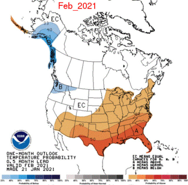
Yep. The ones for our area released with two weeks lead for Dec and Jan were equally bad. The December one had us in the “equal chances” area, and the January one had us above normal. -
Western PA/Pittsburgh Winter 2021/22 Discussion
TimB replied to meatwad's topic in Upstate New York/Pennsylvania
I feel like the CPC can issue a map that looks like this every month and be right more often than not: Then again, they issued this one at the same time last year: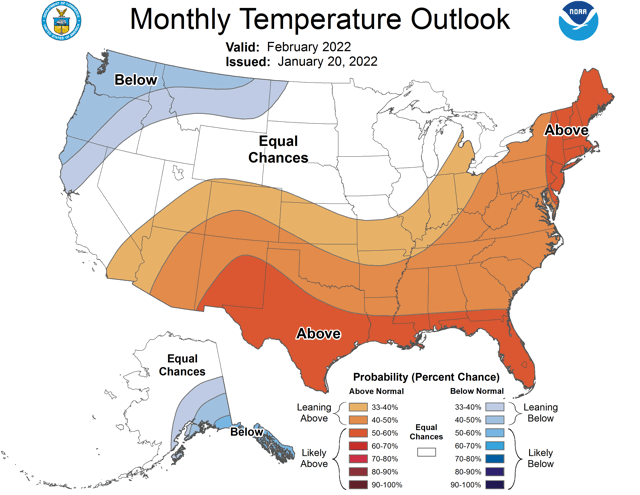

-
Western PA/Pittsburgh Winter 2021/22 Discussion
TimB replied to meatwad's topic in Upstate New York/Pennsylvania
I mean, if we do end up with two crappy winter months and one decent to good one, I’m glad it was January. -
Western PA/Pittsburgh Winter 2021/22 Discussion
TimB replied to meatwad's topic in Upstate New York/Pennsylvania
Nothing noteworthy for the first two systems on the Euro. Sunday system is weak, Tuesday system slides too far north for anything impactful. -
Western PA/Pittsburgh Winter 2021/22 Discussion
TimB replied to meatwad's topic in Upstate New York/Pennsylvania
On the positive side, GFS and CMC both give us at least an inch on Sunday and a couple to a few inches from the early week system. -
Western PA/Pittsburgh Winter 2021/22 Discussion
TimB replied to meatwad's topic in Upstate New York/Pennsylvania
It is, unfortunately, the pattern changer. The 500 pattern looks much more like December after that, but it’s a week and a half away and hopefully won’t have the kind of staying power it had in December. -
Western PA/Pittsburgh Winter 2021/22 Discussion
TimB replied to meatwad's topic in Upstate New York/Pennsylvania
That’s the problem, if this phases with the southern stream I could see major p-type issues. -
Western PA/Pittsburgh Winter 2021/22 Discussion
TimB replied to meatwad's topic in Upstate New York/Pennsylvania
I believe so, yes. Aren’t they both clippers in some form, except the Mon-Tues one tries to tap into southern stream moisture? -
Western PA/Pittsburgh Winter 2021/22 Discussion
TimB replied to meatwad's topic in Upstate New York/Pennsylvania
TWC sees the Monday-Tuesday thing as a possible low end advisory type event, and is carrying a chance of snow on Sunday, so maybe he got it from there? -
Western PA/Pittsburgh Winter 2021/22 Discussion
TimB replied to meatwad's topic in Upstate New York/Pennsylvania
So you’d consider the days of +15 to +20 that we get at least once in just about every non-summer month to be big heat? -
Western PA/Pittsburgh Winter 2021/22 Discussion
TimB replied to meatwad's topic in Upstate New York/Pennsylvania
For example, a couple randomly selected years with a good snowstorm in January: January 19-20, 2001: 6.8” of snow fell, snow depth remained 4”+ through 1/29. January 7, 1996: 9.2” of snow fell, snow depth remained 6”+ through 1/17 (albeit with a couple smaller reinforcing events in between). We just didn’t torch right after these events in years past. And here we are, only down to 41 with snow continuing to melt at 8pm on a day that was only supposed to get to 40.

