TimB
-
Posts
17,229 -
Joined
Content Type
Profiles
Blogs
Forums
American Weather
Media Demo
Store
Gallery
Everything posted by TimB
-

Western PA/Pittsburgh Winter 2021/22 Discussion
TimB replied to meatwad's topic in Upstate New York/Pennsylvania
339 days or something. -
Western PA/Pittsburgh Winter 2021/22 Discussion
TimB replied to meatwad's topic in Upstate New York/Pennsylvania
That long duration one at end of Jan/beginning of Feb. Yes, we did. -
Western PA/Pittsburgh Winter 2021/22 Discussion
TimB replied to meatwad's topic in Upstate New York/Pennsylvania
NAM isn’t terrible, but puts down a swath of 3 feet way up in NE Ohio. -
Western PA/Pittsburgh Winter 2021/22 Discussion
TimB replied to meatwad's topic in Upstate New York/Pennsylvania
Not to be a contrarian, but there was the mid-Feb one where rain went like 100 miles further NW than modeled. But it is incredible that we avoided p-type issues in all the other storms. -
Western PA/Pittsburgh Winter 2021/22 Discussion
TimB replied to meatwad's topic in Upstate New York/Pennsylvania
4 of them being the key. It's going to be hard to get 4 of them this year, so the ones we do get better be good. -
Western PA/Pittsburgh Winter 2021/22 Discussion
TimB replied to meatwad's topic in Upstate New York/Pennsylvania
HRRR still suggests an additional 9" on top of what has fallen so far. -
Western PA/Pittsburgh Winter 2021/22 Discussion
TimB replied to meatwad's topic in Upstate New York/Pennsylvania
I wouldn't say it's doom and gloom for me, more or less just matter of fact statements about how we never get all snow out of a winter storm in Pittsburgh and we all should have known better, including the NWS. -
Western PA/Pittsburgh Winter 2021/22 Discussion
TimB replied to meatwad's topic in Upstate New York/Pennsylvania
Not at all. I don't want a bust, and I still think we get to a respectable total (which, IMO, is >8"), so don't lump me in with him. -
Western PA/Pittsburgh Winter 2021/22 Discussion
TimB replied to meatwad's topic in Upstate New York/Pennsylvania
NWS point & click was updated at 7:52 and suggests another 8" at PIT before snow ends tomorrow. -
Western PA/Pittsburgh Winter 2021/22 Discussion
TimB replied to meatwad's topic in Upstate New York/Pennsylvania
I think we can get there. A lot has to go right, but a lot has gone wrong so far and it has to swing back the other way, right? -
Western PA/Pittsburgh Winter 2021/22 Discussion
TimB replied to meatwad's topic in Upstate New York/Pennsylvania
Keeping the faith that we don't dry slot, but the radar makes that hard. -
Western PA/Pittsburgh Winter 2021/22 Discussion
TimB replied to meatwad's topic in Upstate New York/Pennsylvania
If I recall correctly from the models this morning, there was about 6" on the ground by the time the dry slot encroached at 10 or 11 pm. That's a tough ask. -
Western PA/Pittsburgh Winter 2021/22 Discussion
TimB replied to meatwad's topic in Upstate New York/Pennsylvania
Band of yellow coming up from the south seems to be diminishing as it approaches. -
Western PA/Pittsburgh Winter 2021/22 Discussion
TimB replied to meatwad's topic in Upstate New York/Pennsylvania
It is without a doubt a major p-type bust. Whether or not it matters for totals is still the question. -
Western PA/Pittsburgh Winter 2021/22 Discussion
TimB replied to meatwad's topic in Upstate New York/Pennsylvania
Pouring sleet here. -
Western PA/Pittsburgh Winter 2021/22 Discussion
TimB replied to meatwad's topic in Upstate New York/Pennsylvania
Whatever happens from here on out, this heavy snow is awesome. A few more bands of this would be just the ticket. -
Western PA/Pittsburgh Winter 2021/22 Discussion
TimB replied to meatwad's topic in Upstate New York/Pennsylvania
Doesn’t matter if it’s 35 or 15, all snow is always the underdog when it comes to p-types in a Pittsburgh winter storm. -
Western PA/Pittsburgh Winter 2021/22 Discussion
TimB replied to meatwad's topic in Upstate New York/Pennsylvania
Of course it is, but what can you do? The NAM was showing this issue from the time this storm got into its range, but we all dismissed it (but so did the pros, so I don’t feel as bad). -
Western PA/Pittsburgh Winter 2021/22 Discussion
TimB replied to meatwad's topic in Upstate New York/Pennsylvania
And there’s the sleet/zr. WAA is undefeated in Pittsburgh. -
Western PA/Pittsburgh Winter 2021/22 Discussion
TimB replied to meatwad's topic in Upstate New York/Pennsylvania
Ripping pretty good in the north hills now. Almost all snow. -
Western PA/Pittsburgh Winter 2021/22 Discussion
TimB replied to meatwad's topic in Upstate New York/Pennsylvania
Next panel has a few spots of red. -
Western PA/Pittsburgh Winter 2021/22 Discussion
TimB replied to meatwad's topic in Upstate New York/Pennsylvania
Hopefully those yellows and oranges don’t find a way to split the areas close to the city. Looks like they could. -
Western PA/Pittsburgh Winter 2021/22 Discussion
TimB replied to meatwad's topic in Upstate New York/Pennsylvania
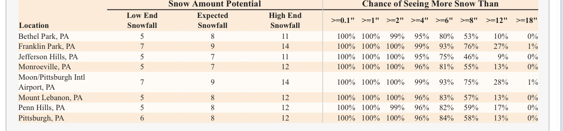
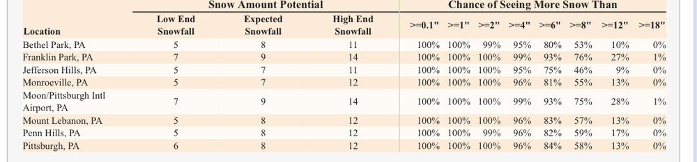
The right side of the chart. Chance of seeing more than 6” is 80% or so for most of the county. -
Western PA/Pittsburgh Winter 2021/22 Discussion
TimB replied to meatwad's topic in Upstate New York/Pennsylvania
-
Western PA/Pittsburgh Winter 2021/22 Discussion
TimB replied to meatwad's topic in Upstate New York/Pennsylvania
What’s more, the NWS now says there’s a solid 20% chance many locations in the immediate Pittsburgh area don’t even see warning level snow .