

TimB
-
Posts
17,230 -
Joined
Content Type
Profiles
Blogs
Forums
American Weather
Media Demo
Store
Gallery
Everything posted by TimB
-

Pittsburgh/Western PA WINTER ‘25/‘26
TimB replied to Burghblizz's topic in Upstate New York/Pennsylvania
NWS has nudged totals up in Allegheny county with the latest update and added the “heavy at times” wording. Maybe laying the groundwork for a warning? -
Central PA Winter 25/26 Discussion and Obs
TimB replied to MAG5035's topic in Upstate New York/Pennsylvania
I’d be embarrassed to have my head as far up my ass as you do. -
Central PA Winter 25/26 Discussion and Obs
TimB replied to MAG5035's topic in Upstate New York/Pennsylvania
Let’s place a friendly bet that the high temp at KMQS (not your improperly sited wx station) is at least 50 on 12/25. If I’m wrong, I won’t interact with your posts again. If I’m right, you’ll accept that AGW is real. -
Central PA Winter 25/26 Discussion and Obs
TimB replied to MAG5035's topic in Upstate New York/Pennsylvania
In what world do you think Christmas will be near normal temps? Literally everything out there shows ridging in that timeframe. -
Pittsburgh/Western PA WINTER ‘25/‘26
TimB replied to Burghblizz's topic in Upstate New York/Pennsylvania
A reminder: even though the mood seems to be we’re failing to cash in from this “great pattern” before it ends next week, all we need is 3.6” tomorrow to be above normal snowfall for December, an amount that seems very possible. -
Pittsburgh/Western PA WINTER ‘25/‘26
TimB replied to Burghblizz's topic in Upstate New York/Pennsylvania
Yep this thing never had a chance. Hope we cash in with a nice little event this weekend because after that, oof. -
Pittsburgh/Western PA WINTER ‘25/‘26
TimB replied to Burghblizz's topic in Upstate New York/Pennsylvania
Mid 30s sfc temps should preclude much if any accumulation regardless of p-type. -
Central PA Winter 25/26 Discussion and Obs
TimB replied to MAG5035's topic in Upstate New York/Pennsylvania
Yeah, just like 1976 and 1989.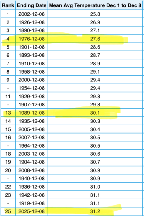
-
You should come back to the place that shall not be named. We miss you.
-
Pittsburgh/Western PA WINTER ‘25/‘26
TimB replied to Burghblizz's topic in Upstate New York/Pennsylvania
Heard on the radio that we could set a daily record low tonight. Granted the record (12) is easily the softest December record on the books, as the 5th is the only day that has never reached single digits. -
Pittsburgh/Western PA WINTER ‘25/‘26
TimB replied to Burghblizz's topic in Upstate New York/Pennsylvania
No one, including myself is complaining about a solid advisory level event on the second day of meteorological winter to kick off the season. We’ll still have our chances this season to break the streak, hopefully. -
Pittsburgh/Western PA WINTER ‘25/‘26
TimB replied to Burghblizz's topic in Upstate New York/Pennsylvania
The streak continues… -
Central PA Fall Discussions and Obs
TimB replied to ChescoWx's topic in Upstate New York/Pennsylvania
Someone who doesn’t get it. Enjoy the new website and the 0.000005 page views per day. -
Central PA Fall Discussions and Obs
TimB replied to ChescoWx's topic in Upstate New York/Pennsylvania
So 6/106 (5.7%) from 1893-1998 and 5/26 (19.2%) from 1999-2024. Interesting. -
Pittsburgh PA Fall 2025 Thread
TimB replied to TheClimateChanger's topic in Upstate New York/Pennsylvania
Models hinting that our first flakes could be just a week or so away. -
Pittsburgh PA Fall 2025 Thread
TimB replied to TheClimateChanger's topic in Upstate New York/Pennsylvania
First freeze at PIT is official. Low this morning was 31. -
Pittsburgh PA Fall 2025 Thread
TimB replied to TheClimateChanger's topic in Upstate New York/Pennsylvania
This will be the 15th fall on record (but 6th out of the past 10 years) that we’ve made it this far into the season without a high below 60. Top 4 is all but clinched, but it’ll be interesting to see just how long we can go.
-
Central PA Fall Discussions and Obs
TimB replied to ChescoWx's topic in Upstate New York/Pennsylvania
Wait a minute, you’re referring to a potential frost/freeze on October 10th as “unseasonably early” when it’s only a handful of days early for many of these locations? -
Pittsburgh PA Fall 2025 Thread
TimB replied to TheClimateChanger's topic in Upstate New York/Pennsylvania
Today is the 15th day with a high of 80+ this September. Septembers with 14+ days of 80+, 1952-2014 (63 years): 9 Septembers with 14+ days of 80+, 2015-2025 (11 years): 7 Crazy that something that used to happen about once every 7 years is now happening more years than not. -
Pittsburgh PA Fall 2025 Thread
TimB replied to TheClimateChanger's topic in Upstate New York/Pennsylvania
Low of 61 at PIT appears to break the streak of sub-60 lows at 21 days. Earliest in the season that we’ve recorded three full weeks of sub-60 lows. -
Pittsburgh PA Fall 2025 Thread
TimB replied to TheClimateChanger's topic in Upstate New York/Pennsylvania
Today will be the 16th below normal day in a row at PIT. By the time this streak ends, it should be the longest streak of below normal since 21 days at this same time of year in 2017. -
The low of 41 at PIT this morning, while short of the daily record of 37, is tied for the 6th coldest low on or before September 8th, all of which occurred in the 1960s and 1980s. Last time we were this cold this early was 9/7/1988.
-
That does stop the August streak, though the 1968 streak did end at 6 on 8/31 and did not continue into September. Looks like we got down to 50 again this morning, so that’s the earliest in the season we’ve ever had 7 consecutive lows of 51 or lower. Cherry picked, but unprecedented.
-
PIT has only recorded 6 consecutive lows of 51 or below in August once, in 1968. We’re currently at 5.
-
With rain chances officially done for the month, we will finish August with 4 days of measurable rainfall at PIT (and one of them had just 0.01”). This ties 1976 for 2nd fewest rainy days in August. There were 3 in 1881.


