

TimB
-
Posts
17,227 -
Joined
Content Type
Profiles
Blogs
Forums
American Weather
Media Demo
Store
Gallery
Everything posted by TimB
-
90 might be in trouble again today. I do think we get there, but still a far cry from historic.
-
Take the day off and cool off in East Nantmeal.
-
The thing that’s odd is they won’t usually predict a foot of snow 4 days out, so that type of bust doesn’t happen. So it’s odd that they’d predict triple digit heat at the same lead time.
-
Pretty impressive if we fall short of 90 when the zone forecast was calling for a high of “near 100” in Allegheny County today as recently as 1pm on Saturday, just 96 hours out.
-
High so far at the airport is 87 or 88 despite hitting 84 by 9:40 this morning and having no cold front and zero precip. I wonder if that’s ever happened.
-
Interestingly, heat advisory criteria have yet to be met at PIT. Highest heat index so far has been 99.
-
Running several degrees ahead of yesterday, but some of that may be a product of a warmer overnight low.
-
You’ll never be convinced. Fortunately everyone on this board and most people in real life consider you an idiot.
-
Looks like another 94. That’s 2 in a row. We haven’t had 3 days in a row of 94+ in any month since 1995.
-
Case in point, the storm currently sitting over MGW airport dropped over an inch of rain in less than a half hour, with a gust to 54mph.
-
DuBois was 92 on the last hourly obs, which ties their monthly record for June.
-
Not international, but I’ve been told you can now fly from Johnstown to Chicago-O’Hare, which was shocking to me.
-
Admit it, you’re a little sad that the insane heat probably won’t be materializing this time. I was, until the storms knocked out tens of thousands of people’s power yesterday and realized that it’s pure luck that it wasn’t me. Now I could take or leave the extreme stuff.
-
These storms developing don’t seem to have much forward motion to them. Seems like they’ll drop a lot of rain wherever they do end up hitting.
-
And here we go. How’s Reddit?
-
Humidity is up from yesterday and it’s already that filtered hazy sunshine imby, so maybe not just at the airport.
-
My grandparents lived in Altoona and used to take me to the park formerly known as Bland’s Park when I was a kid. They didn’t have the water park or the excessively shameless Italian branding back then.
-
And in East Nantmeal it topped out at 82.
-
...RECORD HIGH TEMPERATURE SET AT DUBOIS PA... A RECORD HIGH TEMPERATURE OF 91 DEGREES WAS SET AT DUBOIS PA TODAY. THIS BREAKS THE OLD RECORD OF 89 DEGREES SET IN 1994.
-
A little bit south and it was seemingly all outflow. Lots of branches down from the wind but hardly any rain and a ~25 degree temp drop. Was worried the dog wouldn’t get a walk this afternoon but this is fantastic weather for that.
-
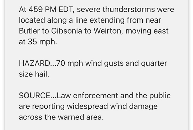
Not raining imby but wind has been gusting hard. Text of the warning would indicate that wind damage is occurring.
-
Some of these storms rolling in look pretty nasty on radar. Let’s hope the power stays on.
-
First 90 is official.
-
A little after 11am in mid-June and it’s already warmer at PIT than it was at any point during 2004.
-
Anyway, plenty of opportunities for extreme heat this week and beyond. Seeing plenty of evidence that the heat simply reloads later in week 2 after a short break.


