

TimB
-
Posts
17,230 -
Joined
Content Type
Profiles
Blogs
Forums
American Weather
Media Demo
Store
Gallery
Everything posted by TimB
-
We’re now up to 1.52” at the airport today, so we’re already up to 4th with more rain tonight and 19 more days in the month.
-
80 feels like such a soft record, considering we’ve been 78 in February and 80 in early March.
-
Hmm. Is PIT cooking the books?
-
Went up to northwest PA and watched the total eclipse. Interesting that the partial eclipse didn’t drop the temp at all at PIT, I thought that was expected even at 97% totality. Looks like Erie went 69 to 55 with the eclipse.
-
On this day last year it was 85 degrees. Today it’s snowing.
-
They screwed that up. Whatever they did, it excluded non-leap years. 2020 is actually in 16th place.
-
Year to date precip is currently in 2nd place behind 2018, which of course was the record year (but a large amount of that precip from 1/1 through early April fell as snow).
-
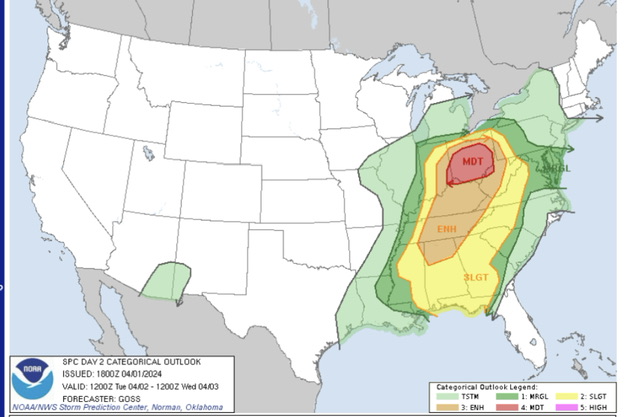
Hell of a way to run a moderate risk.
-
Yesterday’s final official tally of 2.68” makes it the wettest spring day on record for Pittsburgh.
-
Obligatory “imagine if this was snow” post.
-
And still lots of rain to come through.
-
That April 19th-20th period in 1901 now stands as the only two day period in April wetter than yesterday and today. Today has now become the 4th April day on record with 2”+ of precip.
-
This is now the wettest April day ever observed at Pittsburgh international, with 1.62” and counting observed since 1am. The official all time record for any April day is 2.34” on 4/14/1922. We’re up to 6th on the all time list.
-
Last Day 2 moderate risk for anywhere in PBZ’s domain was issued on 7/26/2014. That system ultimately produced 2 hail reports and 8 wind reports in PBZ’s area, so we dodged that one.
-
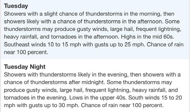
Severe risk also seems to have really amped up with latest guidance. SPC sounded the alarms with their latest outlook: And PBZ introduced this to the zone forecast for Allegheny County:
-
Trying to figure out how PIT only topped at 96 in that heatwave.
-
I’m going to go with August 2025. It’s the month that has gone the longest without being below normal (last time was 2017, which broke a streak of 18 straight above normal months), but it’s going to be a hot summer and won’t happen this year.
-
So far in 2024 we have had 17 days that were 15+ degrees above normal and 16 days that were below normal by any amount. The last day that was 15+ degrees below normal was 5/3/23.
-
You’ll stop at nothing to prove your stupid little agenda. Trust me, the last time someone will think about these records you’ve meticulously been keeping for decades will probably be about 3 years after you’re dead, maybe less. Is it even worth it?
-
72.7 to 73.3 is still warming.
-
This doesn’t belong in regional subforums. But good to see you admit that your flawed data and the NCEI data both show warming.
-
The flowers started poking through in early February just as they did last year, I’ve seen a lot of geese already returning north, it’s crazy. The recent “cold” spell featured one below normal day at PIT (a whole 2 degrees below normal), and we’re sitting at +13 for the month to date. A 9th straight above normal month here is a lock, and it’s probably much the same in central PA, even if the anomalies this month haven’t been quite as big.
-
Well, July 2020 was the warmest July and second warmest month ever recorded at the airport, only behind August 1995.
-
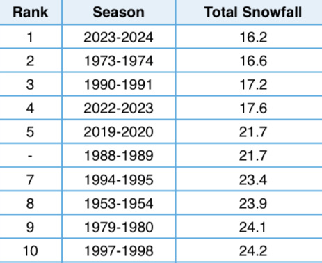
0.4” at the official observing site still keeps us 0.4” short of 1973-74. Below are the current standings for the 10 worst winters in the 75 or so years that obs have been taken at (near?) the airport. I still think we can squeeze out a half inch during the upcoming cold period and avoid setting that record, but it seems it’d be a tall order to get out of the bottom 5, three of which have occurred in the past 5 winters.
-
So today’s sixers game was a godsend.


