

TimB
-
Posts
17,229 -
Joined
Content Type
Profiles
Blogs
Forums
American Weather
Media Demo
Store
Gallery
Everything posted by TimB
-

Pittsburgh, PA Fall 2024 Thread
TimB replied to TheClimateChanger's topic in Upstate New York/Pennsylvania
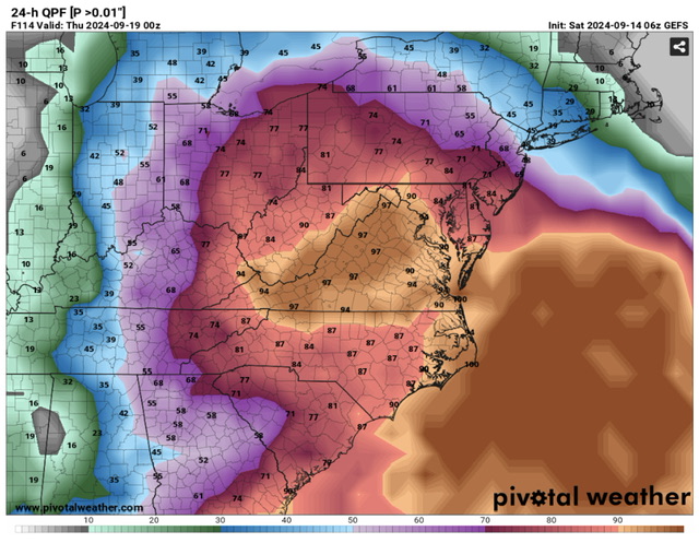
Interesting that 81% of GEFS members have measurable rain Wednesday, but the NWS is rolling with a dry forecast for the entire period.
-
Pittsburgh, PA Fall 2024 Thread
TimB replied to TheClimateChanger's topic in Upstate New York/Pennsylvania
I wonder what the record is for most consecutive above normal months at PIT. I know we had that stretch from February 2016-July 2017 where we had 18 straight above normal months, though a few of those would now be considered below normal according to the 1991-2020 normals. -
Pittsburgh, PA Fall 2024 Thread
TimB replied to TheClimateChanger's topic in Upstate New York/Pennsylvania
The highlighted is not a date you want to see in the 8-14 day analogs if you like fall weather: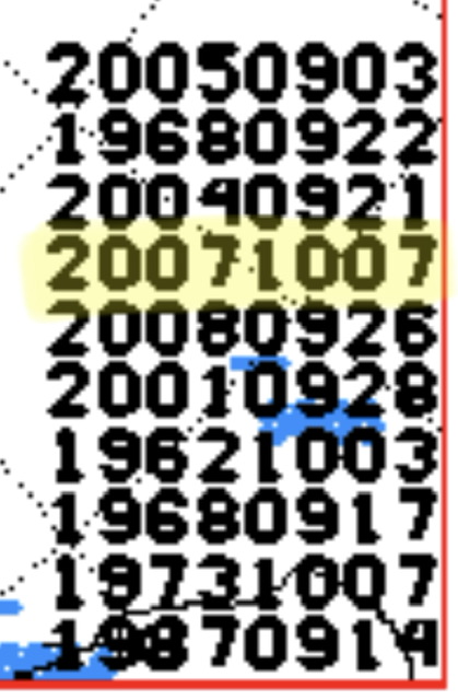
-
Pittsburgh, PA Fall 2024 Thread
TimB replied to TheClimateChanger's topic in Upstate New York/Pennsylvania
Interesting to note that of the 10 streaks of 21+ days of zero measurable precip that Pittsburgh has recorded, 9 of them happened at least partially in fall. The only exception happened in May/June 2023. So fall months can be incredibly dry around here, but there’s always tropical remnants to give us hope. -
Pittsburgh, PA Fall 2024 Thread
TimB replied to TheClimateChanger's topic in Upstate New York/Pennsylvania
Was looking at that this morning. There have been entire GFS runs that show exactly zero qpf through 384. Not just a one off, it seems every other run for the past few days has depicted this. I think the over is a safe bet in this scenario, but model runs depicting zero precip for 16 days are incredibly rare around here. -
That streak looks to continue for at least another week, maybe longer. They have recorded exactly two below normal days in that span, both in August but not consecutive. This forum would spontaneously combust if any eastern locale recorded 98 above normal days out of 100.
-
That said, I can also see the other side, that PA is in a stretch of fantastic early fall weather and fretting over what is or what used to be (perceived or actual) is secondary to the absolutely perfect weather now and for the foreseeable future. You could also make the “who the hell wants to wake up to 25 degrees in August” argument, even if it wasn’t ever that cold imby or yours.
-
Oh I’m not running away from the intent of my original post, as it’s pretty obvious what I’m getting at and the data bear it out pretty well. I’m a little more concerned that you’re using one rogue day in March almost 40 years ago to refute the fact that fall comes later than it used to.
-
It used to get into the 20s in Bradford in August (1982 and 1968 also got to 26 and 29 respectively on the same date, so it wasn’t just a one off), and now we’re marveling at mid to upper 30s in early September, which, Blizz is right, are pretty rare these days. 36 on or before September 3 has occurred in: 1958, 1963, 1964, 1965, 1967, 1968, 1969, 1970, 1971, 1972 (yep, that’s 9 years out of 10), 1976, 1979, 1981, 1982, 1984, 1986, 1988, 1992, 1993, 1994, 1997, 1998, 2000, 2001, 2004, and 2009. So break that down into 3 equal periods: 1958-1979: 12 of 22 years got to 36 on or before 9/3 1980-2001: 12 of 22 years got to 36 on or before 9/3 2002-2023: 2 of 22 years (and none of the last 14) got to 36 on or before 9/3 Oh, and your March record high on 3/30/86. It was matched in 2012, a full week earlier in the spring season. (But you knew this.)
-
Bradford’s AVERAGE first freeze 1957-2000: 9/16 Bradford’s EARLIEST first freeze 2001-present: 9/16 (average this century is 10/2)
-
It’s not days of yore, when BFD reached a low of 25 on 8/29/86, but it’ll do.
-
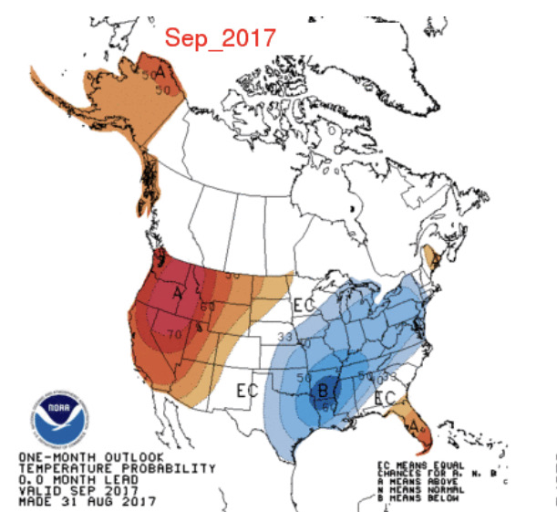
2017 comes to mind. Here was the CPC outlook for that above-normal September. Oof.
-
Still sitting in 2nd, just behind 1880 for warmest YTD on record and over a degree ahead of 2012, which was the warmest YTD at the airport through 8/29. Remarkably, we are running almost a full 3 degrees ahead of 2023 through 8/29, which is currently the warmest full year on record at the airport.
-
Temp at PIT has surged to 93. This is now the first time since 2002 that PIT has hit 92+ four days in a row.
-
Would think an outside shot tomorrow depending on frontal timing, but unlikely especially with the airport being west. I hope we don’t see 90 in September but it’s hard to rule out.
-
Still going, now it’s been up to at least 91 for the 4th day in a row. On that note, the only other summer where Pittsburgh International had a 3+ day streak of 91+ in each of the three summer months was…. 1988.
-
I suspect we put 2 more 90s on the board today and tomorrow. We shall see.
-
Also yesterday’s high of 94, combined with the first 94 degree day of the season on 6/17, makes 70 days between our first and last 94 degree days of the season. That longevity of 94+ degree days hasn’t happened since 1953.
-
AGC has hit 95. Two weeks later in the season than the previous latest date it hit 95 since coming back online in 1999. 94 at PIT ties us for the hottest day of the summer so far.
-
Not too far away, Wheeling recorded a high of 98, which ties 7/7/2012 as the hottest day on record since that station came back online in 1998 after a several decades-long hiatus.
-
Very well may have attained an unexpected 90 at PIT today. Will be either 89 or 90, but there were 10 straight 5-min obs of 90 so we’ll have to wait for the daily report.
-
Mesos going nuts with the midweek heat. I feel like the NAM doesn’t usually put out crazy numbers, but it has us at 95 Wednesday afternoon. RDPS has its issues with overmixing, but it’s spitting out triple digits with dewpoints still in the upper 60s. It’ll be interesting to see how hot we can go if it doesn’t rain.
-
Was looking at the record low of 45 set at Parkersburg on Wednesday and that was not only the 3rd coldest low ever recorded there in August, but the earliest in the late summer/early fall season instance of 45F or lower in a nearly 100 year period of record.
-
PIT is at exactly normal for the month to date. We should dip ever so slightly below today, but the back end of the month looks warm enough to clinch our 14th straight + month.
-
And there’s our first 40s at PIT in August in a decade.

