

SnowenOutThere
-
Posts
3,473 -
Joined
-
Last visited
Content Type
Profiles
Blogs
Forums
American Weather
Media Demo
Store
Gallery
Posts posted by SnowenOutThere
-
-
-
3 minutes ago, psuhoffman said:
And the op gfs was a very good look at the end headed into the holiday week!
Only 15 days away! Still always nice to see these changes actually happen instead of getting can kicked, and would be nice to get something that week so hoping it continues to show up.

-
 3
3
-
-
11 minutes ago, CAPE said:
That's odd because I tracked that threat from so far out I wasn't going to miss any of it. First time I looked out and saw precip falling it was snow and 32, and an hour before it wasn't doing anything. May have been a mix at the beginning. Precip was heavier to the south and east so maybe it took a bit longer to cool the lower levels up your way. Most of that storm temps were in the 20s here.
Apparently I woke up at 2:30 that morning and recorded a video documenting what was happening. Primary P-type was sleet but up until then was plain rain, temp was 36 at the time. Next video I have is at 4:30am and shows heavy snow and a coating to an inch already accumulated so most likely started as rain for a couple hours before switching over and then dumping till like 12pm. Total was around 6.5-7 inches then we had a storm later that week that gave another 4 with a middle of the night death band.
-
1
-
-
-
3 minutes ago, Weather Will said:
WB EURO control, I know just one member, but the number of runs I have seen this is ridiculous.

The digital snowfall thread is NOT a place for this. Please instead take this to the panic room, good vibes in this thread only.
-
BWI: 35.8"
DCA: 28.2"
IAD: 37.1"
RIC: 20.7"Tiebreaker SBY: 32.7"
-
1
-
-
14 minutes ago, mattie g said:
I was about to post this. Trough digs nicely and is trying to get that low under us. If temps can cooperate, we might be onto something.
Is unfortunate its at the temp max of the day, would probably be a lot easier to get snow into the urban areas if it was timed 12 hours sooner or later. Still exciting to see!
-
Christmas snow is a LOCK*

*Your definition of a lock may be different than mine
-
6
-
-


it’s never too early to unfounded radar hallucinations
-
 6
6
-
-
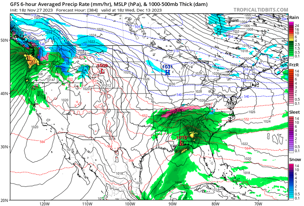
Who decided 384 was the cutoff for model runs, I want to have a friendly “chat” with them tonight about the 18z gfs.
-
2
-
5
-
 1
1
-
-
47 minutes ago, paulythegun said:
Offshore wind platforms are causing this!
A very reputable source told me it was the old underwater volcanoes at it again.
-
1
-
-
13 minutes ago, stormy said:
The GEFS is close to the ECM Control for the next 15 days: Zonal flow with weak lift makes the difference.
I might not be that learned at weather but I'm pretty sure this is not zonal flow in the slightest

-
6
-
-
5 minutes ago, stormy said:
Ideally, reasonable people express reasonable ideas on this site. Unreasonable crap needs to die. More and more supporters are getting disillusioned.
Reasonable ideas like anthropogenic climate change, which I know you must totally agree with due to the vast scientific consensus on it if you claim that "unreasonable crap needs to die". Also second part is bolded because ???
-
1
-
-
2 minutes ago, CAPE said:


Even has another potential storm afterwards. If only it wasn't so far away ...

-
1
-
3
-
-
14 minutes ago, aldie 22 said:
I'm not going to EJ or Ji it but seeing a 384 hour GFS op run with zero precip from start to finish isn't much fun to look at.
CMC with the same look too
-
 1
1
-
-
16 minutes ago, Maestrobjwa said:
Now I also get why somebody doesn't wanna have this discussion right now. May be fun to speculate (as scientific debates do and that's great) but let's not forget the emotional side of this (and I get it, maybe some scientific debaters are more logic than emotion and don't get that side of things, lol). It is indeed the last snow hope we're looking at here...like it legit could tell us what the rest of our lives in terms of snow will look like here, and some prefer to stay optimistic and not entertain the other.
Not quite sure why just mentioning different possibilities for this winter and what they mean for our region should impact our emotions ... its not like we have failed yet. We are simply pointing out what a failure would mean, which is an important discussion to have, burying our heads in the sand won't change that.
-
6 minutes ago, CAPE said:
maybe a bit longer

Just have to stay with that look for 10 days
-
2
-
-
5 minutes ago, Ji said:
this is just shameful friends....shame on you e39
.thumb.png.d737b5b3362dba926fae867783843d83.png)
Lmao it has snowfall rates of 2 plus inch per hour and gusts to 80 over the Delmarva. I mean it does technically have a 1/50 chance of happening right? I mean we can round 1/50 to like 10/50 and at that point why not 50/50 ... thats how math works so tell everyone about our guarantied blizzard.
-
1
-
3
-
1
-
-
Just now, CAPE said:
Awesome. I bet you were ready given all the discussion about atmospheric blocking and ENSO on this forum. That pic is a composite from Dec 1 to Feb 15 iirc, during the epic 2009-10 season ofc.
yeah, mentioned which year it was in the assignment and how it was DCA's snowiest. Best part of the class is there was another kid who was interested in meteorology. The teacher asked about how nino was going to influence our snowfall which was a fun discussion.
-
1
-
-
@CAPE I got to use your pfp for an example of -NAO blocking on an AP environmental science worksheet today and how it sets up colder conditions on the east coast. It was all about how NAO and el nino/nina affects the weather and I've never been so ready for an assignment in my life.
-
5
-
-
2 minutes ago, CAPE said:
Storms can still cut, esp early in the season. I get your point though. Big difference with the features in the NPAC.
I just like to see how if/when storms cut on guidance there is actual cold air delivery behind them, which was too much to ask for last year excluding the Christmas fiasco
-
1
-
-
Just now, CAPE said:
They have been 'seeing' that for multiple runs now. The looks in the NA on some recent runs are interesting.
You can tell even from the op runs that it *looks* different than the crappy Nina base state we’ve been in for years with there being actual cold behind storms instead of endless warm cutters.
-
2
-
-
27 minutes ago, CAPE said:
..and save winter for the greater DC area
He was completely correct last year …
-
3
-
-
26 minutes ago, Eskimo Joe said:
What are those benchmarks? You can DM me if you don't want the peanut gallery giving you static.
I'd also be interested in getting those statistics if you share them


.png.e9fa3499920b288f6d5d94edae47f786.png)
12/10-11 Disco / Obs - Rain/Snow/Wind Event
in Mid Atlantic
Posted
Gfs looks somewhat improved, gets snow closer to the metro areas than 6z