

SnowenOutThere
-
Posts
4,007 -
Joined
-
Last visited
Content Type
Profiles
Blogs
Forums
American Weather
Media Demo
Store
Gallery
Posts posted by SnowenOutThere
-
-
Well at least it will be hard to miss this storm to the north or south...

-
Gfs came in a bit better
-
11 minutes ago, Eskimo Joe said:
Watch this thing become a 3" - 5" event last minute.
The vibe with this storm has felt sorta similar to last years storms which trended worse in the medium range then got brought back short range
-
 1
1
-
 1
1
-
-
18 minutes ago, Interstate said:
When did society become so soft? I mean it should be up to the parents... if they feel like a dust of snow is too much, they dont bring them.
You realize most kids get to school by bus right?
-
3 minutes ago, stormtracker said:
We get some sympathy flakes...but it's clearly heading out to sea.
I mean its not gonna turn up the coast but we do get into its precip shield

-
1
-
1
-
-
Precip shield out west looks more consolidated as the north stream seems less problematic
-
Just now, CAPE said:
You need to look at more than a snow map to understand why the modeled snowfall looks this way. Plus this is a total snow map.
Oh I was looking at the H5 map and the vort map I just had no idea what would actually lead to a better storm after comparing runs. I can tell setups like the one we just had on an H5 level but not this mess of phases.
-
1
-
-
1 hour ago, ers-wxman1 said:
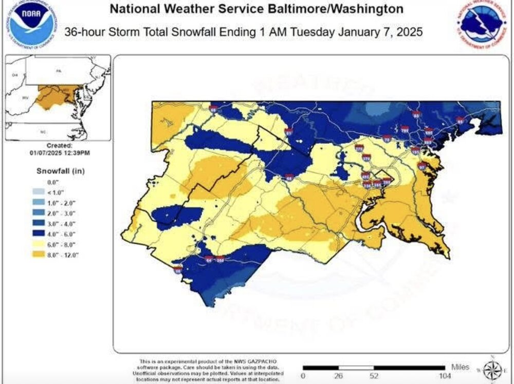
The southern end of the blue hole in ffx county is where I was for the event and I think my frustration was justified after seeing this map
-
I have no idea what just happened with the GFS, but it does still snow.

-
3
-
 1
1
-
 1
1
-
-
2 minutes ago, Eskimo Joe said:
Yea if the initial push was better, then DCA would've had a legit shot at 10", IMO.
It seemed like accumulation shut off for a good part of Nova post 6-7am which really hurt us. If anything I remember being up from 2:30am onwards and at first the rates were .8 inch per hour and we were ahead of schedule but then the heaviest stuff never came north.
-
You know people are bored when they’re debating the hour 84 NAM
-
 2
2
-
1
-
-
Measured 6.25 on the ground with compaction, so total snowfall is probably somewhere near 7. Got 5.0 inches before the ULL, and overall maybe a little disappointing but hard to complain when it’s so pretty out.
-
2
-
-
11 minutes ago, Terpeast said:
Obligatory deck pic. Still pixie flakes
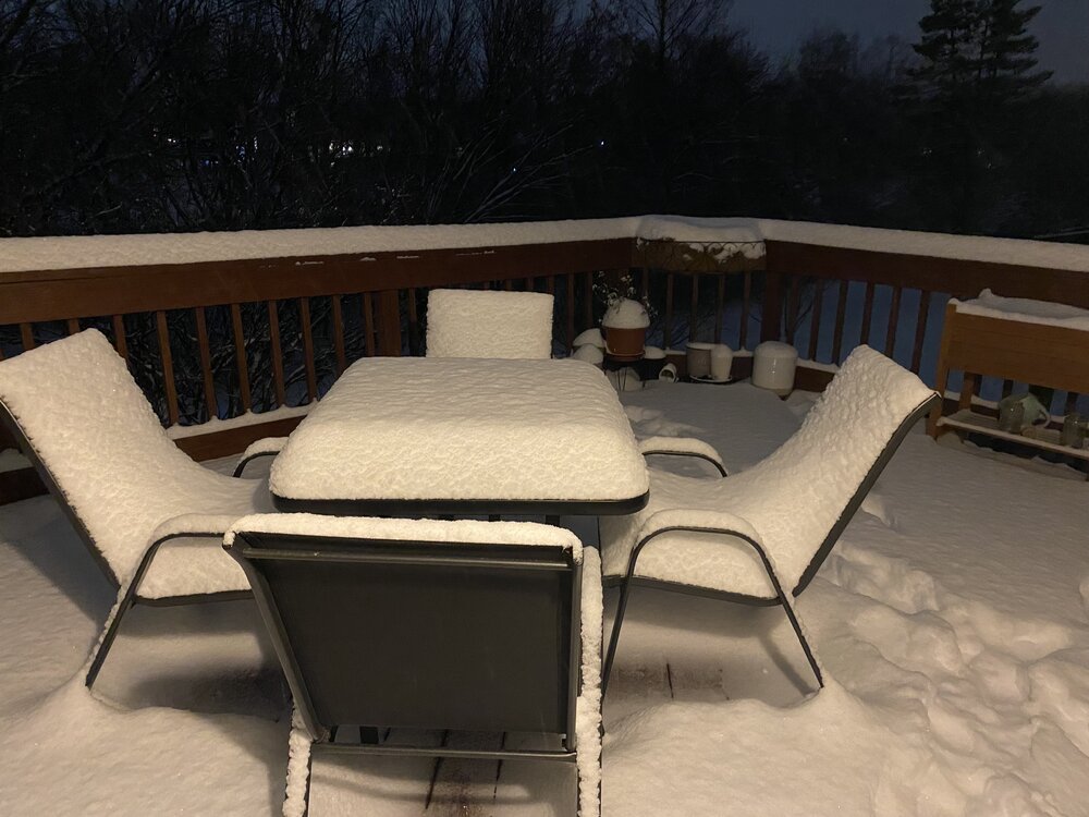
Do you think we can get in on some better flakes before the second round ends?
-
1
-
-
Finally have dendrites, looks like this storm may end well.
-
Under some dark greens and seeing some decent flakes
-
Have had some light to moderate snow in Reston for the past 45 minutes. Was a nice surprise while sledding
-
Looks like it’ll be between bands again for Reston. Hope all of those up north can makeup for their relative miss this morning.

-
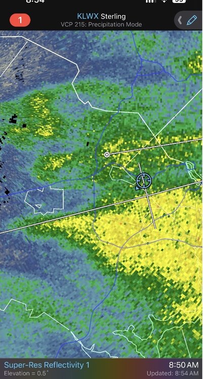
7 minutes ago, weatherbook said:
The band extends west through Fairfax County and has produced some of the best snowfall rates in Oakton that I've seen with this storm.
Finally was able to see non needles fall from the sky
-
5 minutes ago, Chris_B said:
So close yet so far. Congratulations Alexandria and points south.
That’s how it was for me when the band was further west, hopefully the next band gets just a hair north
-
Got a couple nice flakes to mix in with the usual snizzle but it couldn’t even last more than 10 minutes sadly. Looks like this will be a time where southern ffx county will help get me out of school
-
1
-
-
3 minutes ago, H2O said:
Same. Back to all snow
Sharp cutoff line for that snow is running through Burke right now, can confirm if you’re north of it it’s extremely light pixie dust
-
1
-
-
Did stay up from 2:30am till 6am and was a little worried this may happen for parts of Nova as the bands always seemed to die coming off the mountains before blossoming again east of DC. Oh well, we still got snow
-
1
-
-
16 minutes ago, clskinsfan said:
I have freezing drizzle out here during the lull. Just under 5 inches of snow. The model busts are going to be legendary here. No chance I come anywhere close to 8 inches.
At around 4.75 inches with only spotty radar returns left out west for the morning batch so also seems like this forecast may not be great for me. Glad I hedged my totals with 6-10+
-
3
-
-
33 minutes ago, yoda said:
My 4.1" as of 5:30 is good by you too then
")
Yep, now up to 4.25 by 6am, but Im going to sleep a bit till the band out west gets here


1/11/25: The little weekend thing.
in Mid Atlantic
Posted
HRRR came in a little bit wetter with a widespread inch or more in the DC area.