.jpg.7212c88cd7a6ee918250d4a9d2a8d183.jpg)

Chicago916
-
Posts
322 -
Joined
-
Last visited
Content Type
Profiles
Blogs
Forums
American Weather
Media Demo
Store
Gallery
Everything posted by Chicago916
-
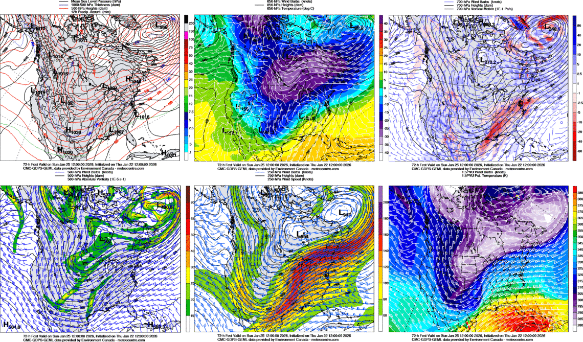
1/24-1/25 Major Winter Storm - S. IL, IN, and OH
Chicago916 replied to A-L-E-K's topic in Lakes/Ohio Valley
Nothing here and I'm right next door lmao in 5 minutes that'll change -
1/24-1/25 Major Winter Storm - S. IL, IN, and OH
Chicago916 replied to A-L-E-K's topic in Lakes/Ohio Valley
Interesting the different shapes to lake effect/lake enhancement. Almost like there's fingers of lake enhanced snow so between the fingers there's virtually no snow. -
1/24-1/25 Major Winter Storm - S. IL, IN, and OH
Chicago916 replied to A-L-E-K's topic in Lakes/Ohio Valley
4-5 inches and still cranking! Should get to 6 with it still snowing and the main LE band still north of here! -
1/24-1/25 Major Winter Storm - S. IL, IN, and OH
Chicago916 replied to A-L-E-K's topic in Lakes/Ohio Valley
Gotta enjoy the single season of Wagler while we have it. -
1/24-1/25 Major Winter Storm - S. IL, IN, and OH
Chicago916 replied to A-L-E-K's topic in Lakes/Ohio Valley
Flakes starting in Avondale -
1/24-1/25 Major Winter Storm - S. IL, IN, and OH
Chicago916 replied to A-L-E-K's topic in Lakes/Ohio Valley
Breaking news: Took 24hr lead time, but trash GFS finally caved to EURO lol -
1/24-1/25 Major Winter Storm - S. IL, IN, and OH
Chicago916 replied to A-L-E-K's topic in Lakes/Ohio Valley
Our friends? Idts. -
Bring on thunderstorms
-
1/24-1/25 Major Winter Storm - S. IL, IN, and OH
Chicago916 replied to A-L-E-K's topic in Lakes/Ohio Valley
Welp, instead of any positive shift north the last 36hrs, every model shifted south. So much for cautious optimism. Maybe we'll be able to smell the snow. -
1/24-1/25 Major Winter Storm - S. IL, IN, and OH
Chicago916 replied to A-L-E-K's topic in Lakes/Ohio Valley
Ukie continues to look nice at least. Team international models. (Phrasing) -
1/24-1/25 Major Winter Storm - S. IL, IN, and OH
Chicago916 replied to A-L-E-K's topic in Lakes/Ohio Valley
I believe in Tom https://www.facebook.com/share/p/17NEQck89Q/ -
1/24-1/25 Major Winter Storm - S. IL, IN, and OH
Chicago916 replied to A-L-E-K's topic in Lakes/Ohio Valley
I want whatever this experimental Canadian model is smoking.
-
1/24-1/25 Major Winter Storm - S. IL, IN, and OH
Chicago916 replied to A-L-E-K's topic in Lakes/Ohio Valley
I feel that. Today's theme is just minor adjustments everywhere tbh. Still could see a surprise since I think some of the features are still up in the Arctic. -
1/24-1/25 Major Winter Storm - S. IL, IN, and OH
Chicago916 replied to A-L-E-K's topic in Lakes/Ohio Valley
Looks the same as last run to me -
Was just thinking about all the budget cuts to the NOAA and how it impacts modeling. I wonder what verification scores are now vs previous years (winter and summer comparisons). Feels like modeling is pretty bad.
-
1/24-1/25 Major Winter Storm - S. IL, IN, and OH
Chicago916 replied to A-L-E-K's topic in Lakes/Ohio Valley
So you're saying now until the start of the system it won't continue to baby step better, upping snow totals each new run (jk but I really miss those days) -
1/24-1/25 Major Winter Storm - S. IL, IN, and OH
Chicago916 replied to A-L-E-K's topic in Lakes/Ohio Valley
Unsurprisingly the GEFS went boom They should just decommission that model...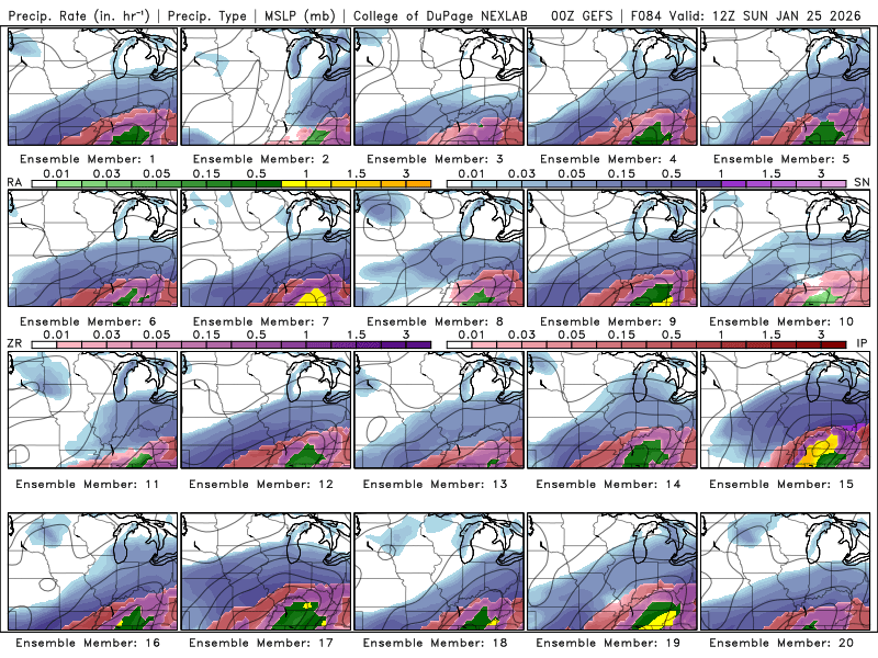
-
1/24-1/25 Major Winter Storm - S. IL, IN, and OH
Chicago916 replied to A-L-E-K's topic in Lakes/Ohio Valley
Sampling of the Baja low not included in the NAM (doesn't matter cuz it sucks anyways) but good for other models. So that won't explain any changes seen down there. Looks like some sondes made the NAM after all https://x.com/i/status/2014131199120162993 -
1/24-1/25 Major Winter Storm - S. IL, IN, and OH
Chicago916 replied to A-L-E-K's topic in Lakes/Ohio Valley
End result on the EPS looks similar, so wouldn't look too much into that -
1/24-1/25 Major Winter Storm - S. IL, IN, and OH
Chicago916 replied to A-L-E-K's topic in Lakes/Ohio Valley
When the measly ICON is northwest, bombs away -
1/24-1/25 Major Winter Storm - S. IL, IN, and OH
Chicago916 replied to A-L-E-K's topic in Lakes/Ohio Valley
Sounds like the Baja Low will be sampled for tonight's 0z runs, so we should have that answer then. -
Winter 2025-26 Medium/Long Range Discussion
Chicago916 replied to michsnowfreak's topic in Lakes/Ohio Valley
At 15-1 to 20-1 ratios, I think Chicago gets 20in+ with that run. Certified big dog potential. Everyone's eyes peeled to the Euro soon. -
Winter 2025-26 Medium/Long Range Discussion
Chicago916 replied to michsnowfreak's topic in Lakes/Ohio Valley
Um guys. The latest UKIE... Hard to ignore that. 500mb is just crazy. (Ninja'd cuz didn't even see the random lake effect this model loves to always wrongly include) -
Winter 2025-26 Medium/Long Range Discussion
Chicago916 replied to michsnowfreak's topic in Lakes/Ohio Valley
I say we give this the ol no hitter treatment for now. -
Winter 2025-26 Medium/Long Range Discussion
Chicago916 replied to michsnowfreak's topic in Lakes/Ohio Valley
Recon missions with better sampling too will be super meaningful. Regardless of outcome here, very interesting set-up. The South will get demolished regardless.