

Jt17
-
Posts
363 -
Joined
-
Last visited
Content Type
Profiles
Blogs
Forums
American Weather
Media Demo
Store
Gallery
Posts posted by Jt17
-
-
4 minutes ago, USCG RS said:
Wow..
I mentioned GEFS trended west and got crickets
-
 5
5
-
 1
1
-
-
10 minutes ago, wthrmn654 said:
There discussion talked about the 18z nam and they were essentially discounting that outcome.
Not saying they used that for there graphics.
My bad. That's good to know. It did look ridiculous after all.
-
Just now, wthrmn654 said:
That and there using a model blend between the euro/gfs and some nam. 12z nam was showing big snows for everyone just about. To no one seeing anything at 18z and for that reason they do not see that happening and are essentially tossing that run. But that could change.
That nam run wasn't included in its guidance. It came after 3:20. That being said the other mesoscale model with any legitimacy the rgem didn't fall apart like the nam at all. In fact the rgem was a little better than it's previous run.
-
1
-
-
1 minute ago, coastalplainsnowman said:
Question for the experts - I'm trying to square what I see on the Upton site, which as of 3:20 PM has all of LI with about a 25% chance of 18+ inches and an expected snowfall of a foot for the Nassau/Suffolk border, with, at least what I'm perceiving, as a 'show's [basically] over, oh well' vibe here. I realize that the pros on here won't necessarily agree Upton all the time, but surprised that there's this much disparity. Why is that? Is in part because most posters here are more north & west, where it is a different story even on Upton's maps?
It's because one of the 2 major weather models relied on most heavily to forecast weather in the US is still showing over a foot for most of Long Island.
-
1
-
-
2 minutes ago, wthrmn654 said:
And it still can shift west. I'm saying it didn't follow the NAMs big hop shift east at least.
It didn't shift east either.
-
GEFS trended "west" - quotes because it was super tiny lol
-
1
-
-
2 minutes ago, Doorman said:
How's this

Trendy....
It still has that double barrel low thing going on but I think the models will resolve this eventually. Choosing the left side would be ideal for us lol
-
1
-
-
1 minute ago, Franklin0529 said:
It still went east.
It really didn't man, maybe the depicted precip field did slightly, but the actual low didn't and H5 even looked better than last run.
-
1
-
-
1 minute ago, USCG RS said:
H5 much better this run. Sfc goes the opposite.
Which is why meteorologists continue to give credence to the possibility that this could substantially change
-
1
-
-
3 minutes ago, nycsnow said:
Gfs isn’t gonna do it
Right but the positive outlook would be that the GFS looks like it might have stopped with the east trend.
-
2
-
-
Just now, Franklin0529 said:
Gfs leaving alot energy behind.
Looks the same as 12z, it still wouldn't take major changes from this run to end up with a major storm.
-
1
-
-
GFS running...
-
Just now, Brian5671 said:
I wonder if they are getting some new data....
Not being facetious when I say this, but they are always getting new data. Thus we shouldn't be surprised to see waffling around. Especially in this set up.
-
Just now, MJO812 said:
Maybe this is the period where the models lose the storm and then bring it back later.
can't remember this NOT happening
-
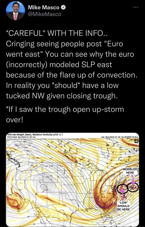
2 minutes ago, Jt17 said:
18z nam at hour 63:

then at 66 same run:

I can't imagine it's going to hop around like this, all of the models seem to be shooting darts with the location of the LP
-
1
-
-
18z nam at hour 63:
then at 66:
-
1 minute ago, Franklin0529 said:
What is the nam doing lol
The models are really struggling with where the LP should be focused.
-
1
-
-
1 minute ago, weatherpruf said:
All I have to do is look at the number of people browsing here; what a drop off in interest!
I think you or somebody else said this earlier. Then the EURO came out and it was stuffed with people. I guarantee at 4:45 it will be packed in here.
-
3 minutes ago, jdj5211 said:
the Euro on it's previous 06z run and 12z run and NAM on it's 12z model run did a similar thing with the low depiction. Hopefully it's just temporary noise that resolves over the next few runs and gets the weenies of the ledge.
-
1
-
-
Now would be a perfect time for NAM to continue to mess with us

-
1 minute ago, Franklin0529 said:
The low should've been closer to the coast based off where It closed off
Yea I saw it close off initially and was ready to celebrate
-
4 minutes ago, Franklin0529 said:
There was actually quite a few eps members west of the mean. Couple of ridiculous eastern solutions may have skewed
lol I saw that... I feel like that's part of why there's that double barrel feature in the op. I think it's confused
-
1
-
-
2 minutes ago, MJO812 said:
Eps shifted east from 6z

Pretty proportional shift to the op
-
6 minutes ago, SnoSki14 said:
We're still 2.5 days out so things have room to change.
I'm much more optimistic after the 12z suite even if it looked bad overall.
I like the trends out west. If they continue then it'll translate downstream eventually.
What have you noticed out west that has you more optimistic?


January 28-30th Possible Nor'easter
in New York City Metro
Posted
Bleeding stopped, need the west trend to commence