

Jt17
-
Posts
363 -
Joined
-
Last visited
Content Type
Profiles
Blogs
Forums
American Weather
Media Demo
Store
Gallery
Posts posted by Jt17
-
-
Next Nam run is at 8:30 or 9:30?
-
4 minutes ago, RDRY said:
NAM's fun, but no real support for jackpotting NYC.
Only thing I'll say is Euro keeps trending towards the NAM each run. Euro 6z now looks like NAM 0z (the run that got us weenies pumped)
-
 1
1
-
-
1 minute ago, Rjay said:
Good morning!!
Had this one queued up didn't ya
-
 1
1
-
 5
5
-
-
Just now, MJO812 said:
The inch of precip line on the Euro is now touching NYC.

this snow map now looks like the 12z NAM run that got everybody excited. In fact I believe it's slightly more. Nam reduced the double low look on 6z and we got the jackpot over NYC... hopefully the Euro keeps correcting towards the NAM from here on out.
-
2
-
-
1 minute ago, nightknights said:
Exaggerate much it's not The Day After Tomorrow
It's called levity. Try it ya weirdo.
-
4
-
1
-
-
Just now, dseagull said:
Jersey Shore and LI Burial!
Not the biggest 3k fan, but the trend we wanted hasn't flipped.
Have ya seen the regular Nam? NYC and NJ disappear for years under those totals.
-
2
-
-
4 minutes ago, MJO812 said:
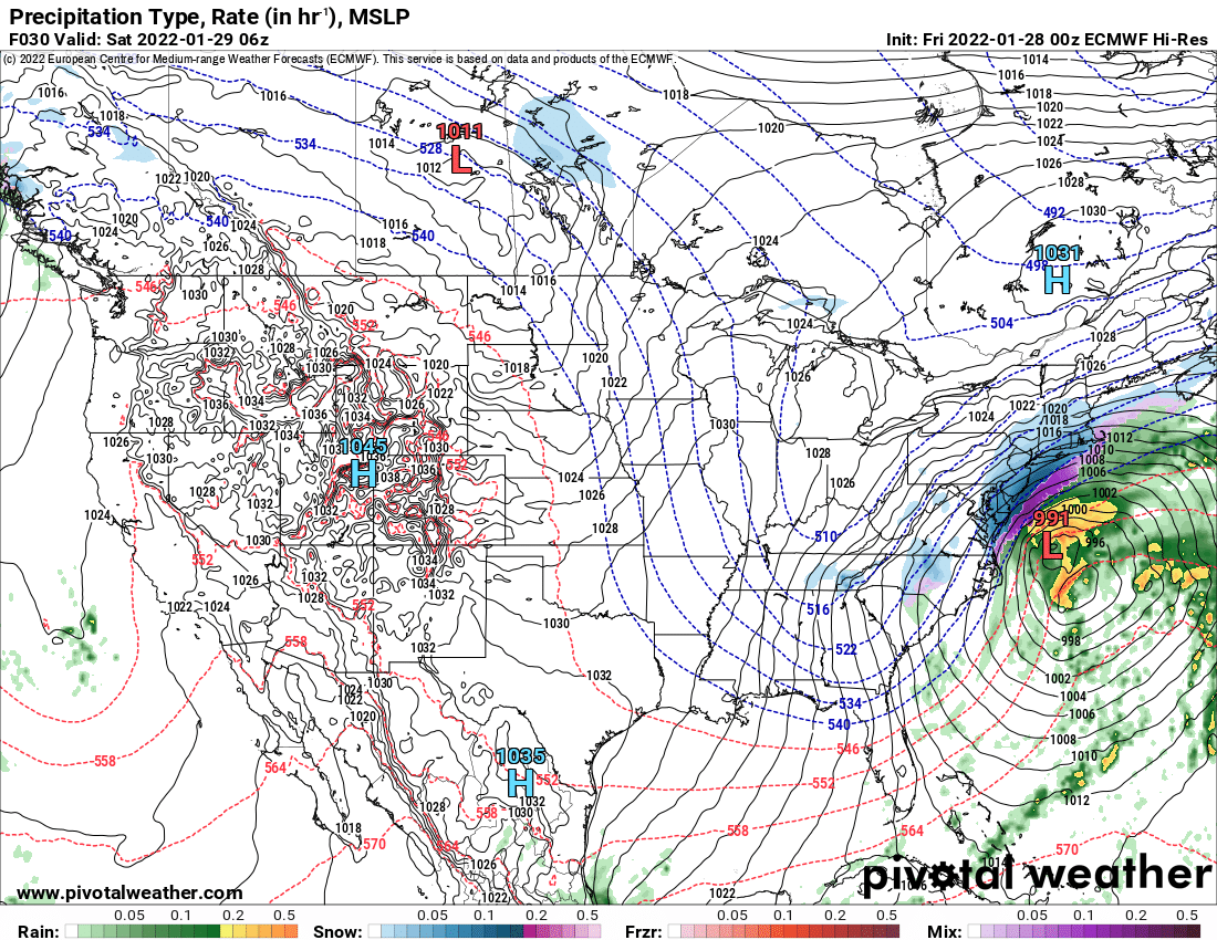
I'm still wondering if the double barrel low is bogus. If so then the storm will shift more west
Euro is about to start
Isn't this the type of feature mesoscale models are supposed to figure out better than the global models?
-
1
-
-
5 minutes ago, jm1220 said:
30" will definitely happen somewhere, maybe a small swath from central/eastern Suffolk into CT and MA.
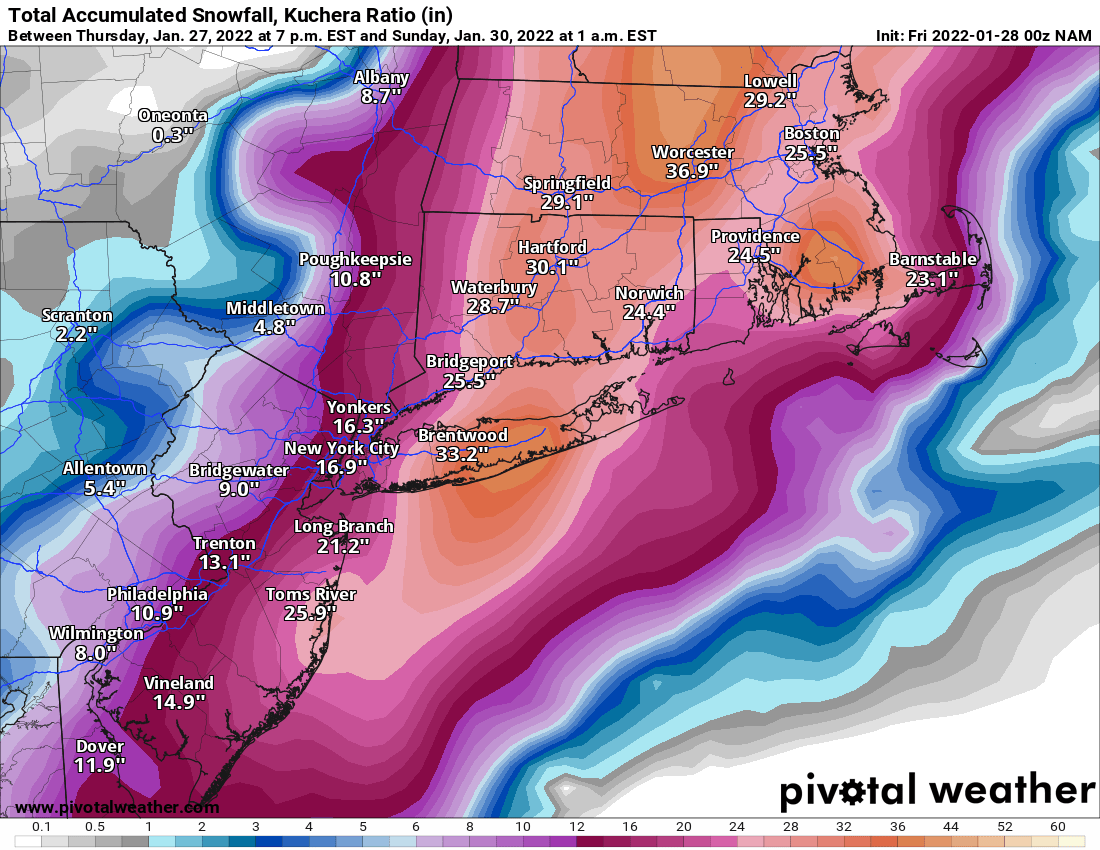
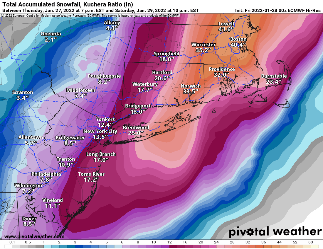
I still think the best of the event will be around the Boston area down through eastern CT/central and east Suffolk but it will be very impressive to just over the Hudson. The one NAM run can't be taken lock stock and barrel when Euro essentially is an 18z carbon copy. Actually the model that may support the furthest west outcome in terms of banding may be the GFS tonight.
I agree with most of your points, however the NAM and Euro are more similar than you're remembering:
NAM:

Euro:
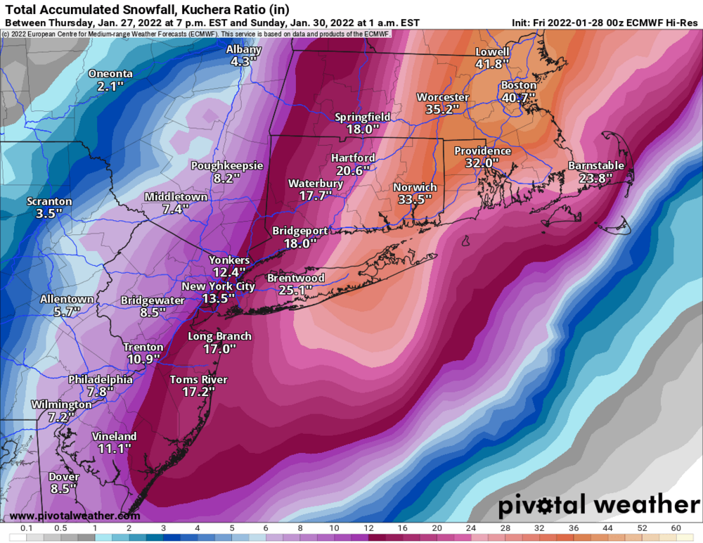
It takes VERY little to change the totals significantly still. NYC could very well see 8 inches or 20 inches with small 20 mile shifts. And they'd totally be reasonable. That's what makes these storms so hard to predict. And as always banding does whatever the heck it wants. I'm 27 miles west of Brentwood in Queens for perspective. On the NAM output that puts the border of queens almost at 2 feet and the Euro at about 18 inches.
-
1
-
-
0z at Hour 30:
almost looks like it consolidates the double lows entirely to the west and it's pretty close to the coast...

Compared to 18z at same time:
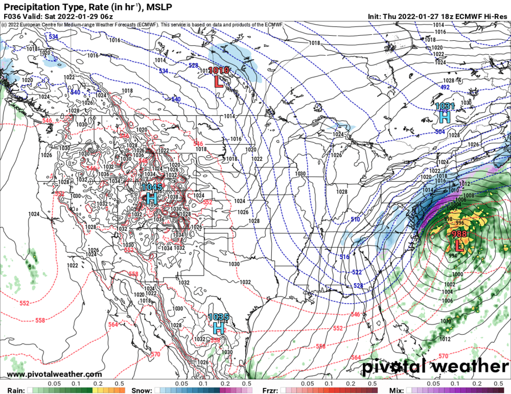
But because it doesn't fully consolidate, at hour 33 on 0z it jumps east about 30-40 miles. How far is nyc out from the bullseye... just saying
")
-
3
-
-
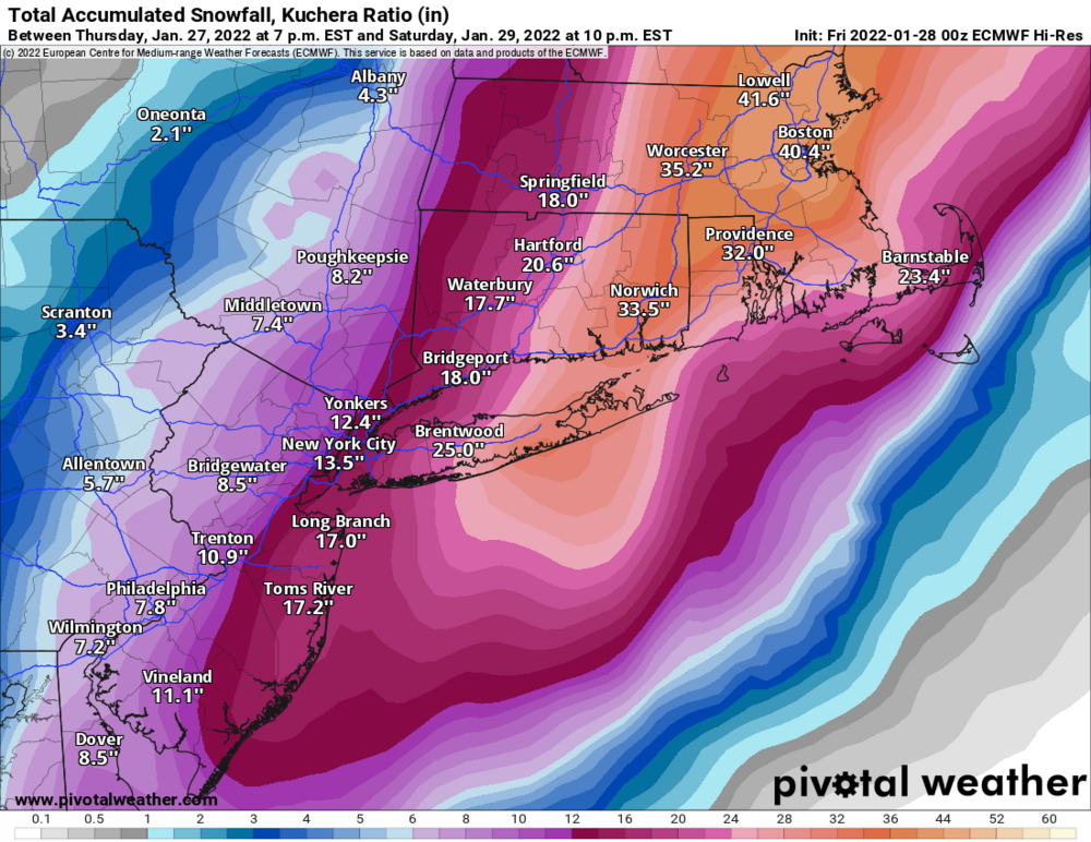
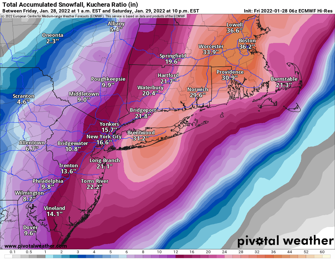
Kuchera:
-
1
-
1
-
-
Long Island disappears in a cloud of snow
-
Just now, David-LI said:
someone do euro pbp
Better, less double barrel focus and it mainly chooses the left LP path. Precip field as depicted on pivot seems smaller, but the intense stuff goes out further, I.e I think a sharper cutoff
-
1
-
-
1 minute ago, MJO812 said:
Euro starting
Head west young man, head west! (Just a little)
-
Just now, Blizzardo said:
It can be blue skys and still be in a blizzard... some folks dont understand..
True... lots of blizzard warnings in the upper midwest and great plains happen without snow falling from the sky.
-
2
-
-
2 minutes ago, psv88 said:
You need the heavy snow rates and strong winds...8" of snow falling over 18 hours wont get you 1/4 mile visibility. The heavy snow bands are still modeled to cut off at the suffolk nassau border.
Euro, Nam, RGEM, CMC... all have decent chunk more than 8 inches falling in nassau county.
-
2
-
-
1 minute ago, USCG RS said:
I definitely misread that. My apologies.
All good, model mayhem and all
-
1
-
-
2 minutes ago, MJO812 said:
Uh
homie, it's a joke - compare the 2 maps side by side. They're very similar.
-
1
-
1
-
-
3 minutes ago, Rjay said:
.thumb.png.7f939cafe4285b99b7b8b69bd255479d.png)
I guess it did come west a bit, keeping our all good trends streak alive.
-
Just now, Rjay said:
.gif.088151859bafab035ed71b82fa908813.gif)
.gif.df56c044e3387f25fbe449260babdcbc.gif)
UKIE on an island by itself
-
7 minutes ago, MJO812 said:

That's just the snow map from the Nam... you can't fool me.
-
2
-
 1
1
-
-
I'd like to see the Euro give us one last treat and get rid of the double barrel low before I go to bed
") lol
lol
-
4
-
-
3 minutes ago, jm1220 said:
Looks good, similar to what it seemed to have at 18z. 1" liquid starting around NYC maybe, no huge death band shown though unlike the NAM/Euro it seems. Similar to RGEM which shows a larger 12" or so area rather than the death band 30" stuff.
Yep looks pretty much the same totals are a little better, but I feel like with a 970 low and plenty of cold air the output in real time will be higher, time will tell!
-
2 minutes ago, USCG RS said:
Held par. Double Barrel low. 970ish just inside BM. Lower numbers though
How so?
1 minute ago, Blizzardo said:And not a small bomb...
sounds like higher numbers lol
-
1
-
-


.png.c2a845272c7be1e2f770d24f26fade32.png)

January 28-30th Possible Nor'easter
in New York City Metro
Posted
If it holds serve I have a feeling we might start to see some of the other models start to follow suite and reduce the double barrel look and go a bit more west like the Nam. Would make a huge difference for city and N&W