

Jt17
-
Posts
363 -
Joined
-
Last visited
Content Type
Profiles
Blogs
Forums
American Weather
Media Demo
Store
Gallery
Posts posted by Jt17
-
-
1 minute ago, MJO812 said:
No it isnt.
It now has a low very close to NJ
My message is now being taken out of context. I was responding to somebody about the previous run.
-
 1
1
-
-
Just now, HeadInTheClouds said:
Yeah but yesterday it was only giving the Canadian Maritimes snow. It's a POS model.
yea agree - well it essentially folded here. If it gets rid of the double barrel look like the Nam and Euro have essentially done, but keeps that track, it will be an absolute monster for NYC metro
-
1 minute ago, jm1220 said:
Lots of us were saying what could happen with a slightly earlier closing off of the low. This could and probably will make shifts but there's nothing to really stop it from coming west at least another 30-40 miles. And it's not a given that it'll trend back east at the last minute. 1/4/18 came west until the very end, I think 12/19/09 trended NW until the end, so did Boxing Day 2010. Sure some do tick back east but it's not a rule.
I just mean the GFS - it's very east still of the other guidance.
-
1 minute ago, justinj said:
What are realistic totals for for central suffolk?
24+++++
-
1
-
-
1 minute ago, RDRY said:
Anyone thinking the GFS will pull a big cave don't know the GFS. Probably a nice shift west, but still an eastern outlier.
Yea just looking for another tick west at this point, let it cave when the snow is already falling like it often does!
-
1 minute ago, keno19 said:

Pretty west of it's previous run, ya?
-
 1
1
-
-
2 minutes ago, larrye said:
Respect your opinion, you probably know more than I do about this stuff. But 39" in western suffolk? Knowing that the NAM usually overstates QPF? It would have to get under some pretty good banding for several hours and I don't know if the intense banding will get far enough west for that. I guess we'll see. But I would prefer to use the 10-1 ratio maps and add a bit to increase the ratios if appropriate for temps ... then stating that higher amounts can be expected underneath areas where banding sets up.
The Kuchera ratios taken verbatim is never a good idea. But when they're really insistent on strong ratios, there's usually a reason. I know a lot of folks take a blend of 10-1 and Kuchera and I think that's generally a good way to look at it. But because of that I think posting both makes sense.
-
2
-
-
Just now, dseagull said:
Hope you haven't spoken too soon. I don't see this tucking nearly close enough either though.
That's part of why the forum has a chance at decent ratios for a change.
-
1
-
-
Just now, larrye said:
Come on ... some of those amounts on the Kuchera maps you know are not gonna happen.
It's hard to say - this is a very cold storm. We're used to mixing at the coast, etc. with our big storms. That ain't it this time.
-
15 minutes ago, Nibor said:14 minutes ago, Rjay said:
The wind is part of the reason why posting kuchera is silly here.
These 2 posts came in, right after the other. Posting 10-1 is just as silly as Kuchera. The ratios will be different all over the map and in a storm this cold almost universally better than 10-1. In parts about Kuchera shows, in others slightly better and others slightly worse. And I'm not positive, but I'm pretty sure Kuchera accounts for wind diminishing the effects of ratios. Can people stop acting like they know better than the physics and algorithms of these models?
-
Not to be greedy... but another 30-40 mile shift and we could get a foot of snow from western NJ to the tip of Long Island... am I asking for too much?
-
1
-
-
Yes w/ratios, but that salmon color is 2 ft and it's brushing up along the outer edges of queens. Just about the width of a boro from 2ft of snow in central park on that NAM run.

-
1
-
-
Totally eyeballing it but it seems to scoot the precip field 30-40 miles west and it's more intense overall...
-
2
-
-
I'll keep it simple, through hr 24 it's closer to the coast
-
10 minutes ago, Metasequoia said:
Are ensembles of much use 24 hours before a storm?
When there's 2 clusters with the op running between the two it's certainly informative.
-
6 minutes ago, HVSnowLover said:
As many have stated due to the winds kuchera is way overdone but still a mammoth storm for Eastern LI into SNE.
The winds aren't going to be nearly as intense on the northwest extent of the decent liquid equivalent. There WILL be ratios. People 100% exaggerate the OTHER direction on this too. If you get .8 inches of liquid and 12 inches of snow... just remember you don't get to be happy about it because you didn't get your 1 inch of liquid.
") (I'm just playing)
(I'm just playing)
-
3
-
-
I bet GEFS has some goodies from its ensemble members.
-
So the whole model suite basically shifted west and most seem to produce deeper LP. I believe that might be called... a trend
-
I think mesoscale models might soon be able to help us sort out this convection sloppiness
-
1
-
-
Just now, Franklin0529 said:
Still got that stupid convection
Yea but it's starting to give more emphasis than it was before to the western barrel...
-
1
-
-
Cavey cave has begun
-
2
-
1
-
-
Just now, EastonSN+ said:
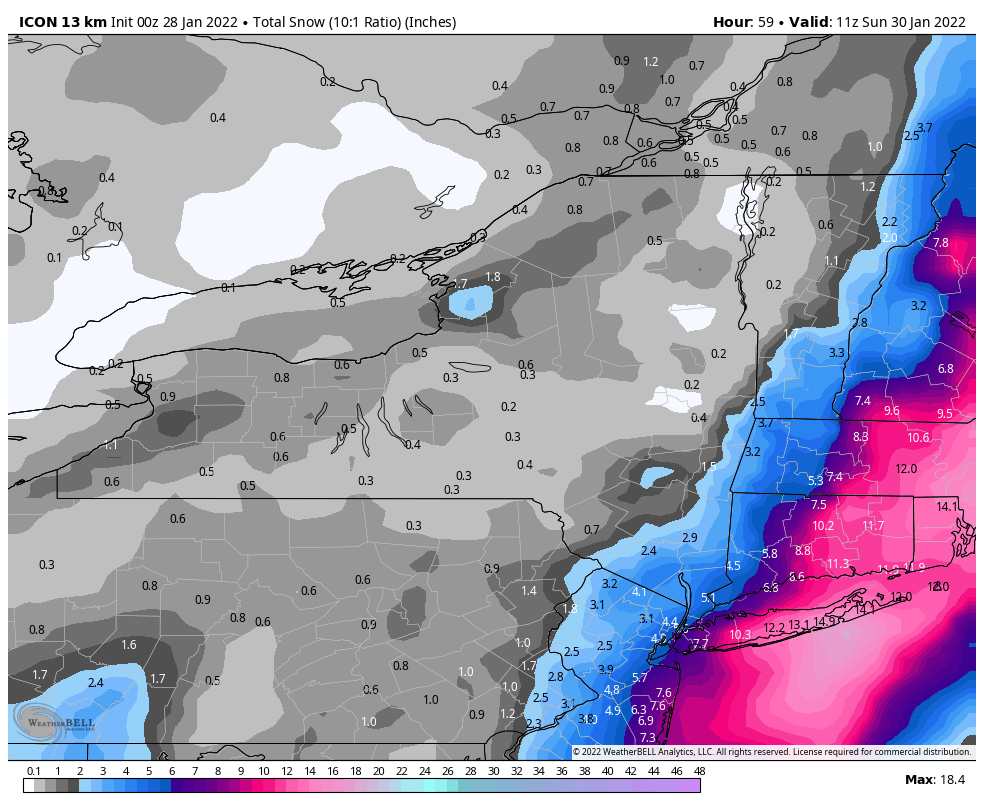
FWIW ICON was a tick better region wide.
Is ICON related to GFS? They seem to sort of spit out similar solutions
-
1
-
-
Just now, wthrmn654 said:
Upton not issuing warnings still interesting..
It's too early for that under normal/any circumstances
-
1
-
-
Rgem has the double barrel feature low and less intense LP, whereas the NAM basically consolidated the lows into one was more westerly focused with the low and deeper... and the RGEM still produced a bigger snow output north and west. I think the NAMs solution would produce a lot more for NYC and NW
January 28-30th Possible Nor'easter
in New York City Metro
Posted
I think from hours 33-42 while it's struggling with the double barrel low look we're being wiped of what could be a decent amount of QPF to the west. If the west low is consolidated the whole time we get something like... the NAM.