

Jt17
-
Posts
372 -
Joined
-
Last visited
Content Type
Profiles
Blogs
Forums
American Weather
Media Demo
Store
Gallery
Posts posted by Jt17
-
-
1 minute ago, weatherpruf said:
Why bother to troll on a weather forum? On a Friday night? I mean, I know there's a pandemic on and people are not going out much, but there's a lot of good tv streaming these days....
exactly... lol
-
2 minutes ago, HVSnowLover said:
The latest RAP has the 1 inch liquid up to the east river
If the RAP is right (it's giving the city consistently run after run 16 inches with ratios now) people are going to wake up with a surprise cuz that ain't 6-10 inches lol
-
 1
1
-
-
11 minutes ago, HVSnowLover said:
I mean even if the rates didn't pick up, if it snowed at this pace from now until noon tomorrow it would be more than 2-4 inches.
he's trolling - that's why I asked where he was from.
-
1 minute ago, donsutherland1 said:
Also, there was a modest increase in snowfall in NYC and just north and west of the City.
that was actually a pretty big jump... 0.56" qpf last run to .73" this run 1.5 inches at 10-1 and about 2.9 inches more with ratios...
-
2
-
-
1 minute ago, Wetbulbs88 said:
I am but I’m from Harlem. Just looking at radar, looks like 2-4”
2-4" inches for the whole storm? lol You actually came here to troll. What a boring place to troll man. It's a bunch of weather nerds.
-
1 minute ago, jm1220 said:
I’ll say that if the 40-50+ mph winds don’t happen tomorrow or in the meat if the storm then ratios might work out. Lift looks good in the temp layer (-12 to -18C) for a while for most of us where dendrites would form. But the 970 or under MB low expected will generate much stronger winds by the morning and would ruin it by breaking the flakes up. Ratios are about the temp where the flakes are made in the cloud and those flakes making it to the ground. I’ve been in 10 degrees before in a bunch of 10-1 ratio at best sand flakes because of poor growth. Not saying it’ll happen here but you can’t just take it’ll be cold and it’s snowing for big ratios.
I understand that, but most of this forum is focused on the immediate area around NYC and that will be far enough from strong winds for most of this storm that it shouldn't really have an impact on snow growth. Which is why the outer extent of the moderate/heavy snow actually could reflect the Kuchera snow totals. Just a hunch here.
-
3 minutes ago, Wetbulbs88 said:
This thing does not look west enough at all.
you in Maryland? lol
-
Just now, HVSnowLover said:
I think people have said the winds would cut ratios which is a reasonable thing but no real wind at the front end of the storm.
I know, but the comments every time somebody mentions ratios or posts a Kuchera map is ridiculous. Not the same type of storm at all but La Guardia got 9 inches of snow on .3 QPF earlier this month. ratios are a THING.
-
6 minutes ago, HVSnowLover said:
Snowing light to moderate but ratios already seem very good as expected, probably close to an inch already.
No no, haven't you heard... there's no such thing as ratios. Snow only falls at 10-1 NO MATTER WHAT.
-
1 minute ago, kat5hurricane said:
Howdy neighbor. I think we're good for 10 inches plus.
Yep I think it could be one of those where the outer boroughs surprise some peoeps... so far looking nice.
-
3 minutes ago, kat5hurricane said:
Been a steady light snow for most of the evening but has noticeably picked up in the last hour. Just took the dog for a walk and I'd say about 1.5 inches with moderate snow. Didn't expect this so soon, it just has the feel of an overperformer.
We're neighbors I'm here in Flushing. Def coming down pretty nicely with about 1.5 inches as well.
-
1
-
-
17 minutes ago, jm1220 said:
I think it’s HRRR/RAP time at this point. And they’re both trending better gradually.
RAP would make a lot of the eternal pessimist crew look bad in here lol
-
2
-
-
Nam looks good at hour 9, not east, but slightly north with a higher pressure and slightly lower pressure. Then at hour 12 it gets back on the double barrel train and gets sheared apart. If it really is just chasing convection like some mets think, we're in better business than we think/it looks like.
-
1
-
-
NAM should be interesting lol
-
Just now, forkyfork said:
blizzards are cool. nuisance snow isn't
Amen.
-
-
1 minute ago, qg_omega said:
Models are extremely on top of each other, there is like no uncertainty. Literally every model has 6 to 8 for NYC.
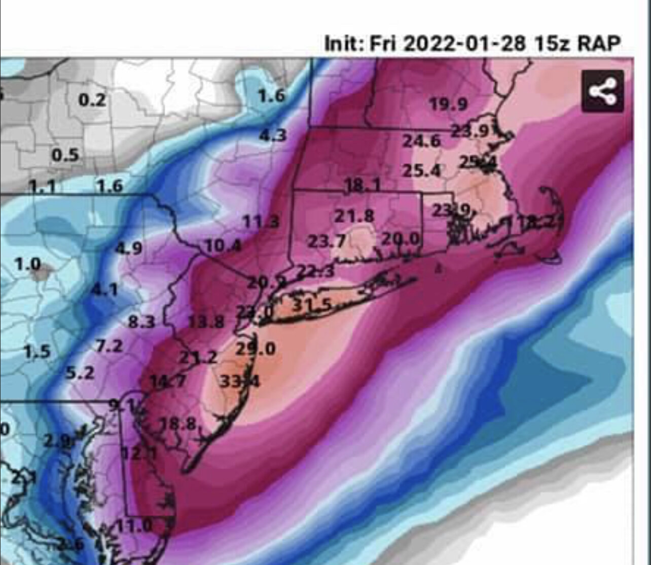
6-8 is 10-1 ratios. Bone cold storm through the entire column will have ratios. The Kuchera are likely closer to reality than 10-1
-
8 minutes ago, Franklin0529 said:
Been happening all morning. Have to take it seriously I think. Hopefully it just consolidates to the western low
I know but it actually got rid of the double low for longer this run than last. Up to hour 18 there was an inch more snow as a result even though the "west" low (and the only low at this point) was centered slightly east to previous runs.
-
Nam looked a little more organized through hour 18 before eventually succumbing to the double barrel look which tugged the best snows east. Would like to see if other models especially the mesoscale models start to delay the double barrel look or eliminate it.
-
1 minute ago, Franklin0529 said:
This happens with every storm, always tick east before show time. Nam is east as well
This is a better look to me than the last run:

previous run:

-
1
-
-
Nam is losing the double low look and picking a path in the middle for the track of the storm... this would make the most sense lol
-
1
-
-
Welp we have the RAP and HRRR on our side so far... look like the Nam and Euro runs from last night. Major levels of snow for NYC Metro and historic looking for LI and the shore on both for now. Yes, yes weenie and all that.
-
3
-
 2
2
-
-
12 minutes ago, Snowlover11 said:
we still got the 15z RAP


Lol 18z looks like 15z
-
1
-
-
6 minutes ago, Snowlover11 said:
we still got the 15z RAP
It still believes in the western low. Less energy stripped and keeps best snows slightly west... wouldn't take much.

January 28/29 Blizzard Observations/Discussion/Nowcasting
in New York City Metro
Posted
Does anybody have a favorite radar they can recommend?