

Jt17
-
Posts
363 -
Joined
-
Last visited
Content Type
Profiles
Blogs
Forums
American Weather
Media Demo
Store
Gallery
Posts posted by Jt17
-
-
1 minute ago, wthrmn654 said:
And your located where?
NYC - queens. The heart of the forum. Where the gfs went from .6 to .8 inches of snow. It didn't cave. (Yet). I'm in the camp of the cmc/euro/nam anyway. I just don't get why anybody is pumping up this gfs run lol
-
3 minutes ago, MJO812 said:
Slightly better
It's much less than people are making it out to be. I'm surprised. I've been calling out people for overemphasizing negative shifts more than they actually were. I'm going to stick with my laurels even in the opposite direction, because this was a tiny wobble on the GFS. Not a shift.
-
 1
1
-
-
1 minute ago, wthrmn654 said:
12 versus 6z


Dude, it's the same lol
-
2
-
-
Just now, wthrmn654 said:
Dude 36 and it's right next to the carolinas..
Looks the same as last run man.
-
Just now, Franklin0529 said:
Looks like the rgem has the double barrel low too. Weird
I think/hope that's just noise - eventually when it's cleaned up closer to the event it should have a positive impact on how the storm eventually looks
-
1 minute ago, Snowlover11 said:
 .
.
It looks VERY similar output wise.
-
1 minute ago, Roger Smith said:
Liking most of what I'm seeing since 06z runs, holding on to the idea that models are just approximations of a larger paradigm which is rapid development over an anomalously warm Atlantic, the details may not be in focus yet, but any track similar to this 12z NAM track will obliterate much of New England and Long Island, banding of course will determine who gets 20" and who gets 30-40, but for NYC would remain optimistic that at least Queens-Brooklyn could get into heavy bands also thanks to LI Sound and 15" seems possible there, would expect maybe 10-12 at NYC and 5-8 at EWR but there's still time for this to take an even better track closer to the 50-55F thermocline out in the ocean, in which case a more equable outcome would occur, without reducing any of the higher forecast amounts.
Earlier I said 24-48 for CT and parts of LI, with very strong winds creating large drifts. Would maybe scale that back slightly but potential still exists for 20-40 inch totals and some gusts to near 70 mph across LI, it looks like the best forcing will be along an ORH-BDR-ISP axis which usually means 3-4 parallel death bands with the best one along that axis, two more to east and one or possibly two more to west. A secondary max from w CT to LGA-JFK possible, the lower amounts between bands will only be slight reductions but possibly up to 10-20 per cent.
Hope the GFS eliminates the uncertainty and shifts west into this otherwise general consensus zone which may still prove to be a touch too far east when the storm gets a sniff of that warm Atlantic. My subjective track would be something like 50 miles west of 12z NAM and without the two-low solution, the leading low would be the triple point of a rapidly occluding bomb cyclone. Min pressure 958 mbs near ACK.
So more like NAM 6z
-
8 minutes ago, mannylovessnow said:
Compare it to 18z:

can't get much more similar. It basically held steady. Could easily trend a little deeper and west tomorrow. Or not, but it wasn't east trend. Saying that gives the wrong idea to people reading the thread. (Not directed at you, just in general)
-
 1
1
-
 1
1
-
-
Checking the snow maps there's perhaps a 10-15 mile east shift for the outer extent of heavy snows. So held pat essentially. It looked more tucked earlier in the run, hopefully that trend continues and pans out a little further up track as a result.
-
1
-
-
Just now, Franklin0529 said:
Still not a bad look. A little east of the cmc, nothing major
It ends up nearly identical to its previous run during showtime - hours 54-69
-
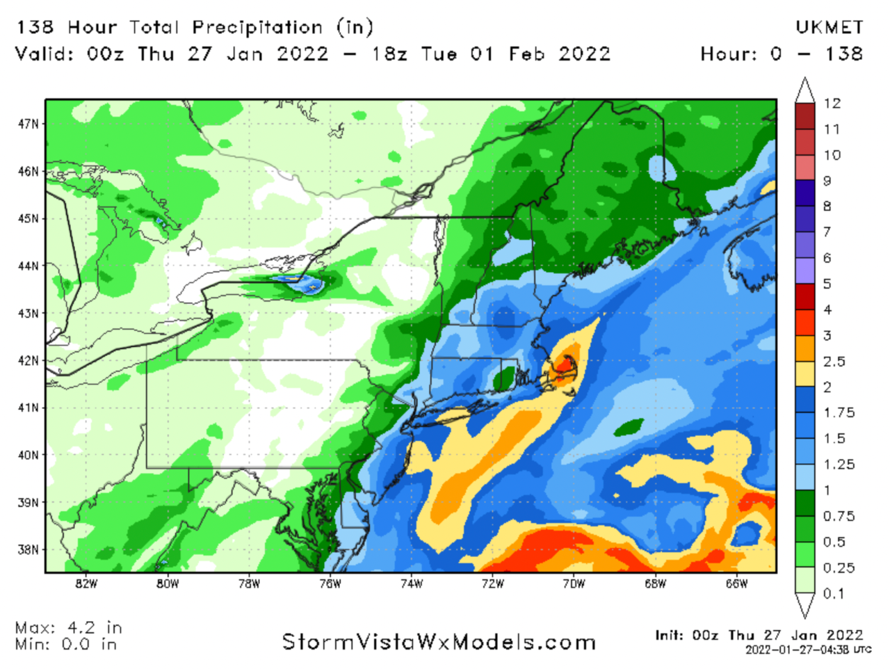
1 minute ago, Wxoutlooksblog said:
Ok at 72 hours it is a tad bit east of where it was last run. But it's not by that much and certainly within the realm of possibility that this ticks back west towards the coast tomorrow.
WX/PT

It's already past us at this point. Before anybody freaks out. It's basically identical at hour 63 to the last run.
-
Would be fun to see Euro get back that 06z look from this morning (bet y'all don't even remember what that looks like now. Feels like weeks ago)
-
 1
1
-
 1
1
-
-
1 minute ago, SnoSki14 said:
Ukie has snowier outputs than CMC which means the CMC is likely too low on amounts.
Really curious to see what the Euro cooks up. Will it follow some of those intense western members?
Snowier than 19.5 for nyc? (Yes this includes ratios)
-
1
-
1
-
-
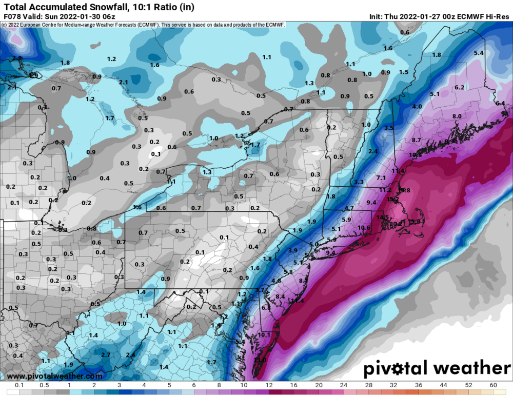
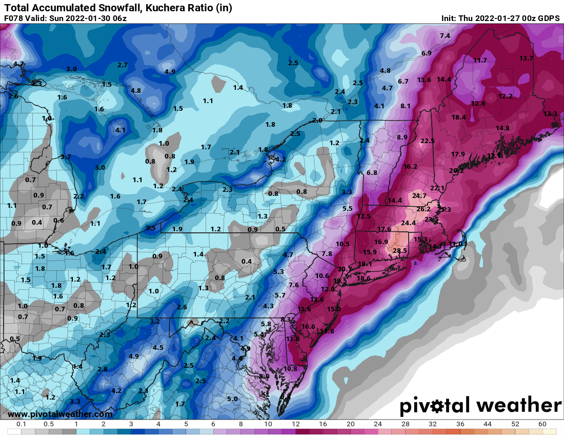
5 minutes ago, wthrmn654 said:
Final cmc totals close up view

That's at 10-1 too kuchera says the ratios should be super good and actually shift the heaviest axis of snow west. Even if it's not as intense as depicted 12-1/13-1 would still be reasonable
-
1
-
-
1 minute ago, MJO812 said:
Wow
Agreed
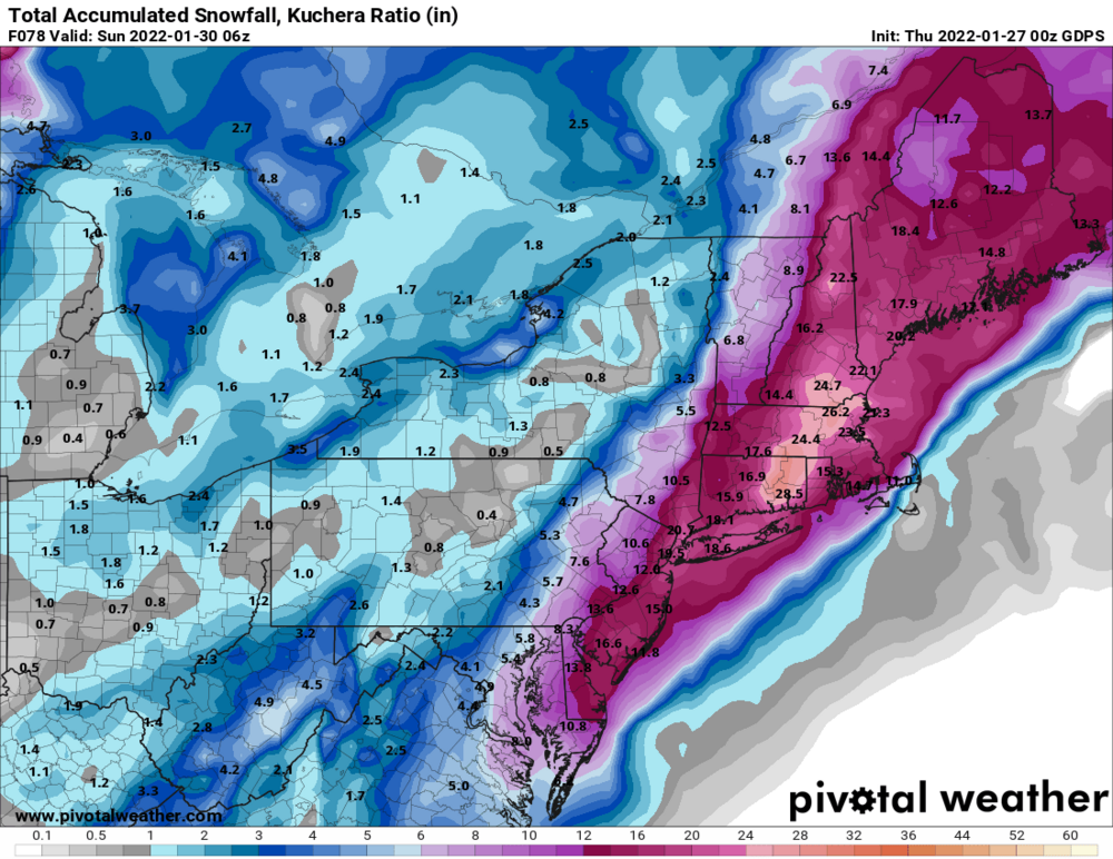
1 minute ago, USCG RS said:Ukie
From nothing to 12-18 for nyc on the ukie at 10-1 ratios?
-
4
-
-
1 minute ago, jcwxguy said:
.thumb.png.e6e933d553ff441a0042d9f2ef7d56be.png)
This looks like the CMC run that initially got us all excited. Well damn.
-
2
-
-
Just now, nycsnow said:
Hearing cmc huge hit
We got pics... Ant?
-
1 minute ago, Rjay said:
Cmc is a hit
Whew
-
Bad run - if CMC looks like rgem, the Goofus will be on its own.
-
2
-
1
-
-
1 minute ago, Brasiluvsnow said:
is that looking better at hour 54 ?
Nope lol
-
1
-
-
2 minutes ago, MJO812 said:

Enormous shift. Wow.
-
2
-
-
2 minutes ago, Rjay said:
Jfc. A bunch of tucked in bombs. Wtf is going on.
That looks... way better - that is maybe more than a tick back west?
-
1 minute ago, HVSnowLover said:
The NAM is all over the place so even if we did get nam'd I wouldn't take it that seriously but it would probably give this forum a lift.
That's what getting nam'd is lol
-
1
-
-
We're prob about to get nam'd

.png.d31a65b6fd3a23935280fe5fca7afa83.png)
January 28-30th Possible Nor'easter
in New York City Metro
Posted
Ok now this is something