

Jt17
-
Posts
363 -
Joined
-
Last visited
Content Type
Profiles
Blogs
Forums
American Weather
Media Demo
Store
Gallery
Posts posted by Jt17
-
-
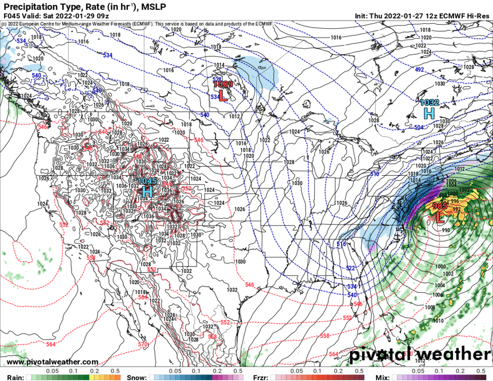
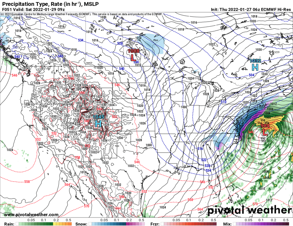
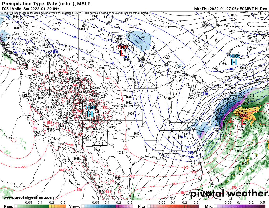
At hr 45 the double barrel low feature is almost entirely eliminated and it looks like it's in a perfect spot to bury I95 in jersey/nyc area, but then at hour 48 it hops a bit to far to the east when it full consolidates the lows into 1 and as a result misses the best snows by 30 miles. VERY close to a 15 inch+ snow storm for Central Park on this run.
-
1 minute ago, NJwx85 said:
Looks a lot like the 12z ICON.
But way better? It got rid of the double barrel feature much earlier and it chose the west LP 962 basically at the benchmark, perhaps a little inside actually...
-
Just now, Franklin0529 said:
Keeps jumping to the eastern convection or it would be a monster.
not this time, it chooses the right playdate it appears at hr 45
-
 2
2
-
 1
1
-
-
This is good...me thinks.
18z:

12z:

-
Just now, Jt17 said:
At 42 it picks the eastern one, but it does look better by a bit than last run at this point.
.... and at 45 it goes back west and I think closes off.
-
1 minute ago, MANDA said:
NAM has same double low structure at H39. In close proximity. Hopefully western one dominates because if it does the 500 looks more a little more favorable than 12Z. Next few time steps should be somewhat interesting.
At 42 it picks the eastern one, but it does look better by a bit than last run at this point.
-
1
-
-
If we could get some of the prettier EPS pictures to look at, I'd be quite grateful. lol
-
1 minute ago, larrye said:
Forgive me ... but why would the model put down surface output that didn't reflect what it sees at the upper levels? There must be something that is causing that.
Of course there are reasons why the depiction ends up the way it does, but I think you're still missing his point. He's trying to say when H5 looks like that it historically has a very signature output in real life and since these are model outputs days in advance he's using some reasoning, history, logic that some of the noise the models are seeing wouldn't actually come into play and we've have a bigger storm for our area. He can correct me if I'm wrong, but I think that's the simplest way to look at it.
-
1
-
-
Just now, jm1220 said:
If you compare this 12z to 0z last night (not 6z) it's overall a little better. So it improved its way even beyond 0z after the lousy 6z. It'll be interesting to see EPS as well and how many tucked in monsters we have.
Agreed. With how close that looked I wouldn't be surprised to see a few crushers in the spread.
-
2 minutes ago, larrye said:
I'll ask you the same question I asked someone else earlier. What good is a favorable H5 if the surface doesn't reflect it? Are you also saying that perhaps the surface features on the next run will better reflect the H5?
It's not even about what's going to be depicted on this run or the next, what he's trying to say is if H5 literally looked like that in real time as the storm happened, the output would be for more snow than the model runs are spitting out.
-
4
-
 1
1
-
-
Anybody have EPS pics?
-
2 minutes ago, EastonSN+ said:
Don't forget the bands are almost always a little west of model depictions during the storm.
Agree, I also am sure the ratios will be between than 10-1 in most places in a cold storm like this. People exaggerate when they say the ratio maps have no merit. The final ratios usually end up somewhere between 10-1 and the Kuchera map output and the western fringes should have a better shot at lining up with the Kuchera ratios anyway.
-
12z:

6z:
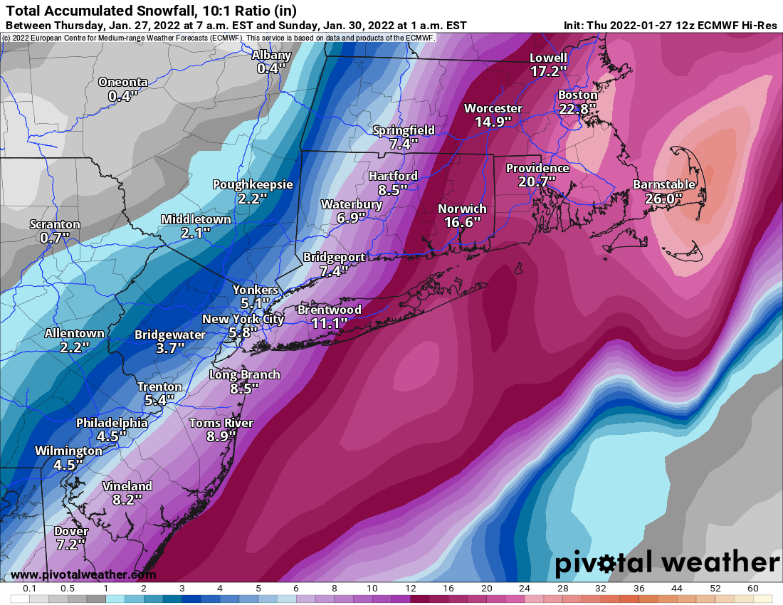
30 mile shift west or so this run and a bit more organized and potent storm.
-
1
-
-
If this is what we got the forum would be pretty happy, though it looked so close to something special that run.
-
Def improved!
12z:
6z:
-
Out to hour 39 on pivotal it looks better
-
1 minute ago, LoboLeader1 said:
this is 18 hours ago before all of the other models hopped way back and GFS has recovered a bit since then fwiw.
-
See you all at 12:47.
-
1
-
-
Remember when everything (except gfs) shifted 200-300 miles last night west taking everybody off the ledge. Well depending on the model you look at, they've drifted back 20-100 miles east. Most around 50 miles. That big shift was only about about 12 hours ago. The storm is 36 hours away. There's plenty of time for changes and on most models it wouldn't take much for something great. I wouldn't write off anything yet, for better or worse.
-
3
-
1
-
-
4 minutes ago, wthrmn654 said:
Gefs deft a west lean
12z

6z

00z

Nice!
-
1
-
-
3 minutes ago, USCG RS said:
100%. However -to me- the GFS is going to be stubborn here. So these baby steps on the GFS are pretty big to me.
I keep drilling this, but the H5 is incredibly close to something special. It really is.
I agree, it's why I haven't given up on something major. Smallest of changes can have a huge impact on how this plays out!
-
1
-
-
6 minutes ago, MJO812 said:
Gefs coming out

Do you have a comparison of the next frame too?
-
1 minute ago, USCG RS said:
No one sees the improvements at H5 on the GFS? No one at all?

It's a little better for sure, but still has a lot of work tho
-
Just now, Snowlover11 said:
baby tick, but again the gfs was way east.
This.


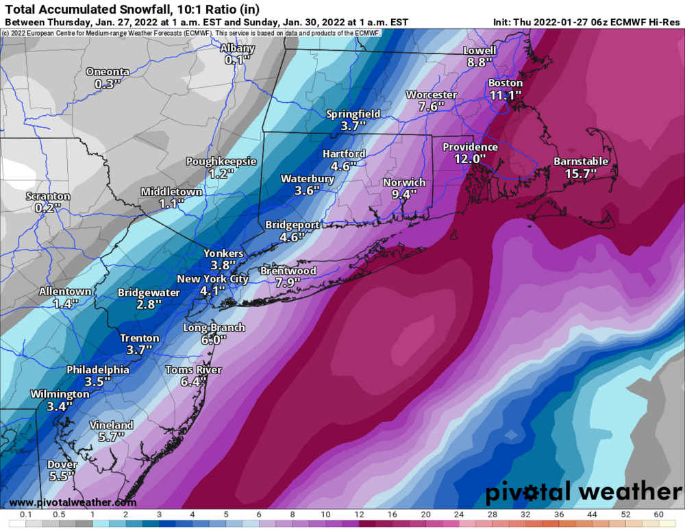
January 28-30th Possible Nor'easter
in New York City Metro
Posted
Agree - this run had a better track and intensity than the qpf output