

Jt17
-
Posts
363 -
Joined
-
Last visited
Content Type
Profiles
Blogs
Forums
American Weather
Media Demo
Store
Gallery
Posts posted by Jt17
-
-
Nam is at 3:30ish? Lol
-
Just now, MJO812 said:
6-12 for the NYC area on this run
Yea hard to tell on Pivotal - also I live in queens so looks more like 12 to me lol
-
 2
2
-
-
1 minute ago, Franklin0529 said:
Euro went from 20" to 7"
Where are you? Didn't for NYC. Looks like NY is still well clear of a foot
-
1
-
-
2 minutes ago, NJwx85 said:
The trough is more amplified at 12z Saturday on the 12z run vs the 06z run. That wasn't necessarily reflected at the surface.
This double barrel look doesn't make sense to me.
Good I thought it looked weird. People say this and I never know what it means but could it be connective feedback? It looked like it phased and then all of a sudden it got torn apart
-
Just now, snowman19 said:
The Euro definitely went east and it doesn’t look way better than the last run as some have posted
Literally nobody posted that. Somebody said it looked more amped and they probably meant at some random hour like 57 or 60
-
1
-
-
4 minutes ago, MJO812 said:
Double barrel low
If did that at 6z but it eventually and slightly earlier seemed to favor the western low and that's when it came back and tucked a little around Long Island. If it's going to evolve with a double barrel low, that's what it's going to have to do for it to be awesome for us still.
-
 1
1
-
-
Now would be a hilarious time for the Goofus to jump 200 miles west next run
-
2
-
 3
3
-
-
Just eyeballing it - it's probably 50 miles east with the best snows. Not terrible. Not ideal, but threat is by no means dead for big snows for the sub-forum
-
2
-
-
5 minutes ago, Franklin0529 said:
Leaving alot energy in the sw. Definitely gonna be east
Looks identical to last run. It just pulled it out at the last minute last run and took a nap south of LI dumping snow on us. But we'll see. Could end up worse of course
-
1
-
-
1 minute ago, Franklin0529 said:
Give me a 6-10" storm I'll be happy
24-36" for me - just looking for a nice winter look, nothing crazy.
-
3
-
-
1 minute ago, crossbowftw3 said:
And does anyone have those?
He's not right, as depicted this is a very cold storm - you're going to have some ratio snows
-
1
-
-
2 minutes ago, jm1220 said:
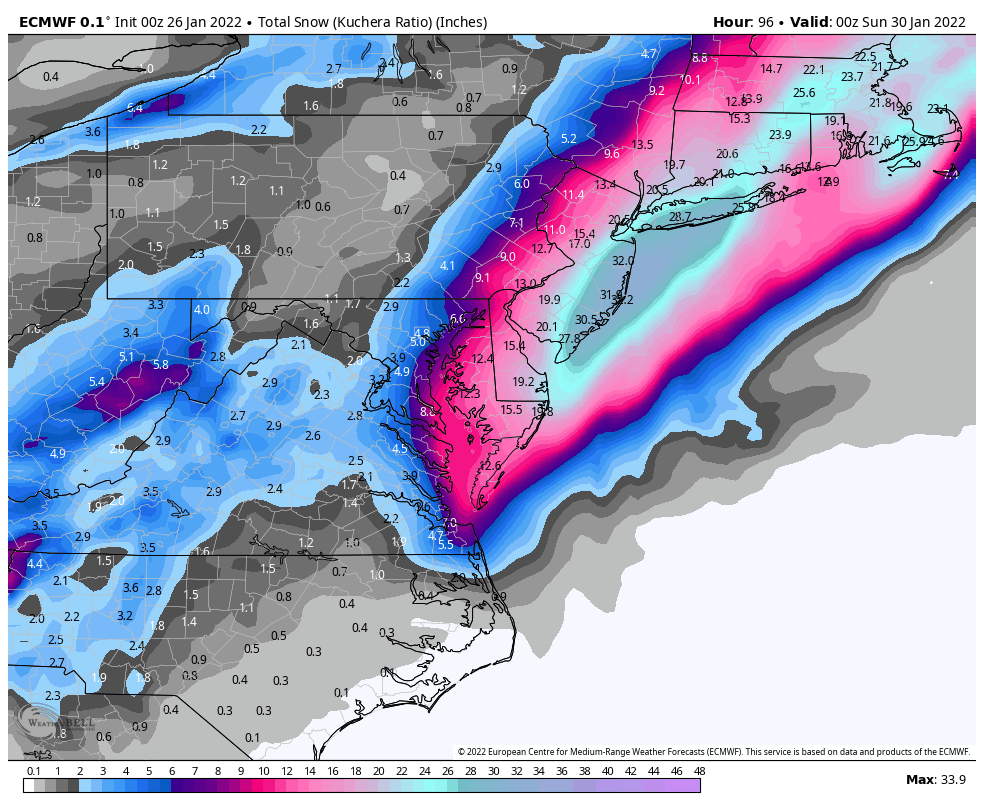
I wouldn’t go with Kuchera maps but to me it looks about the same as 0z if not a little better? 10-1 map was well over a foot from NYC east, 20”+ from roughly me on east. Lows close off and go boom in a great spot which would send heavy snow well to the west.
Its markedly better and it's still snowing hard with hours to go at hour 90.
-
3 minutes ago, weatherpruf said:
Aren't we sort of thinking the Euro is suspect and unreliable? I'm kinda discounting it; isn't it alone at this point? Serious question, not being a troll. Just got up.
06z GFS isn't really too far off from this. It's definitely west of last night and similarly powerful, it just needs a little bit and it starts to back up the euro.
-
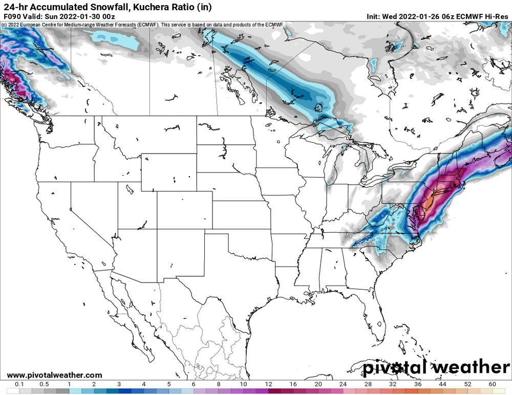
6z euro at 90 (still snowing):
-
2
-
-
2 minutes ago, Yaz said:

whew.
-
1
-
-
1 minute ago, larrye said:
You really think these Kuchera totals will verify N&W?
Even more likely N&W further from the high winds and cold AF, ya?
-
2 minutes ago, HeadInTheClouds said:
For me N and W it cut qpf in half so a little dicey with that run.
For sure there could be some sharp cutoffs so a 10-20 mile east shift in the axis of heavy snows (like on this run compared to last) could be frustrating.
-
1 minute ago, Franklin0529 said:

lol yea sure looks like it caved to the GFS
-
1
-
2
-
-
Just now, Franklin0529 said:
The euro still crushed coastal areas li an NYC.
The main difference wasn't track like people are saying here, it was a little less robust of a system and it moved a little quicker.
-
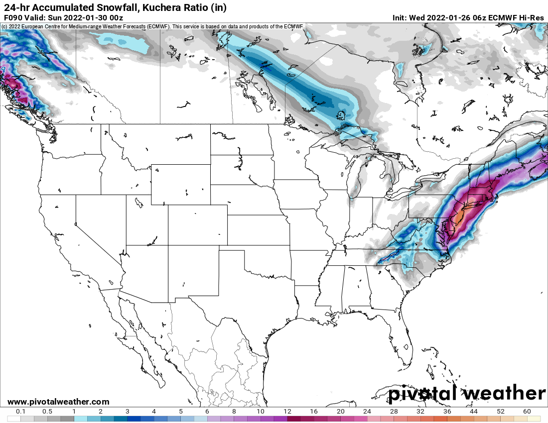
00z:

18z:

-
1
-
-
1 minute ago, Snowlover11 said:
EURO ticks east. it recovers in the end but definitely not like it did in earlier runs.
No, compared to the end of the last op run it's actually ever so slightly west. The low is slightly weaker and the precip field is a little smaller though so I imagine the output will be a bit less, but it was still a good hit. Just noise at this point.
-
1
-
1
-
 1
1
-
-
4 minutes ago, MJO812 said:
Off to bed
Hoping to see good news when I wake up Off to bed
Hoping to see good news when I wake up
worked last night, keep up the good work!
-
2
-
-
Lol so many dumb comments.
Today Canadian trended slightly back West, Euro trended slightly west with a bomb solution supported by a very confident ensemble and the NAM, GFS slightly trended WEST a bit today from where it was last night (though people can't remember 1 run to the next so they think it didn't) and the UKIE has been OTS nearly every run. That's where we're at you weirdos. Nothing really happened except we've gotten more evidence that a powerful storm with serious potential for our area is developing.
-
4
-
5
-
1
-
-
I know everybody's hopes were up for the GFS to tick west, so when it didn't it was disappointing. That being said, it was really just a minor wobble east. If it jumped significantly east, that would be cause for alarm, but for now I would treat it as a nothingburger.
January 28-30th Possible Nor'easter
in New York City Metro
Posted
Lol it appears he's a classic contrarian