

vortex95
-
Posts
728 -
Joined
-
Last visited
Content Type
Profiles
Blogs
Forums
American Weather
Media Demo
Store
Gallery
Everything posted by vortex95
-
ZR = FZRA and IP = PL. Precip codes used prior and after METAR format was adopted in 1996 in the U.S.
-
He didn't. Just his uber weenie status and working w/ him for 10 years warrants a lot of "digs"!
-
I'll dig out of my archives soon booklets I have that summarize all snow events for SNE from the early 1970s to the mid 1990s. I'll take pix of the more significant ones, and send them along.
-
CoastalWx probably gives it a "C" b/c "all that cold and all we could get is two lousy 20"+ storms in Weymouth!!" And he was so "done" w/ NNE getting it all so early!
-
Bookend winter, like 1981-82. Early Dec big S+ (and big bust surprise) and then April blizzard!
-
Yes the first one, I recall that morning, scud off the ocean up the wazoo. Definitely did not look like a pre-snowstorm environment! Too mild. But the convective nature of the storm did its magic across SNE. Big surprise. The second one R/S mix in Woburn w/ .3" of slush when I left for WSI at 1130pm. Got to Rt 3 in Burlington, S+ and quite a ride. Trees and branches all leaning over on the highway (this was when it was still 2 lanes). Pulled into work, and the power when out. Worked a midshift on backup power. Not too bad. Just whiny ppl call saying Intellicast was not available. Those servers were not on the UPS. I got one caller say "people are gonna DIE b/c Intellicast is not available!!!" Yeah, yeah, whatever, I felt like quoting Butt-head and saying, "Hey, it's FREE asswipe!!!" Not a paying client/customer. Scott was probably mad it was down b/c that was one of the only sites that had radar at the time (NWS radar data was not free on the web until 1999).
-
Dec 6-7, 1996. Two sig snow nor'easters in two calendar days. That is exceptional. I know of no other so short time period events for the region, at least in the last 50 years. First storm was tightly wrapped 990 mb low that dumped max of 18" at Cornwall CT and 17.6" at Worthington MA (wet glop that stayed on the trees for the next storm). Then a much larger, more classic coastal came in the evening of the following day w/ 19.5" at New Ipswich NH, 18" at Ashburnham MA, and 16.5" at Union CT (wet glop again that turned to rain many area). So the result w/ 900k w/o power, 500k in MA alone. Biggest power outage for NH up to this time. CoastalWx lamenting in Brockton once again I bet for that event. Funniest thing I recall was the huge lines at DD's the following morning of the second storm (Sunday) in places like Bedford MA. B/c it was largely rain here but not even 5 mi N, wet snow disaster w/ no power. So no one could make coffee and were flocking S to get their fix!
-
Brockton or GHG at the time? Yah, but you just had the Bliz of 97 9 months earlier! "I want everything IMBY no matter what!!!" LOL.
-
K01M - Belmont MS K1S3 - Forsyth MT KGDW - Gladwin MI KK24 - Jamestown KY KN40 - Pittstown NJ KOKH - Oak Habor WA KSPR - Ship Shoal 28 LA 28.599 -91.206 46m
-
So for the dedicated snow weenies here, what is your take on when ASOS reports UP? I always thought it was IP, but can it be a mix of R/S/ or R/IP or S/R/IP? Never ZR?
-
Ayer MA SNOINCR 8! Bright-banding was not melting snowflakes aloft, it was giant dendrites making to the surface! This was a watershed event in a way b/c it was then recognized how important the DGZ was (not all snowflakes created equal!) Seriously, DGZ and flake type was not a thing prior, and least in mainstream forecasting. Pretty MEH sfc low as well for this event. Not much wind either.
-
Most anomalous in terms of weirdness set up I have ever seen for a biggie snowstorm for SNE. Sfc low 600 mi SE of ACK when the big S+ kicked in late night on the 7th and turned the AM commute in a disaster b/c schools were not closed and the area was not prepared. I think the fcst the night before was a general 3-6" in ern MA. IIRC, the ECMWF had the most fcst for the event at 4-8", but even that was 3x too low! Biggest modern day bust for so much snow for a storm in the region. Another one that stands out was 12/23/1997. Fcst was 4-8" at best and we ended up w/ 12-24" for the event. BOS Herald cover the next day, "THEY BLEW IT!" and showed mug shots of all local OCMs! I still have the paper. Also, another big bust 12/5/2005. The CoastalWx special, he recalls that vividly in GHG. Woke up to this wind roar all of sudden from the NW and then when to S+. Small nor'easter very tight but wicked! One of the few times a nor'easter in New England product 100+ mph gusts (I can count on one had the number of times that has happen in the last 5 years). Usually, only hurricanes here give gusts that high! SNOINCR 9 reported in Andover MA area from a reliable source.
-
I bet the animated GIFs from "MID-LO" were hot and heavy for this event!!!! LOL.
-
-
IMHO, range should be limited to 12", such as 12-24", for a region/area.
-
6" or bust for Weymouth!
-
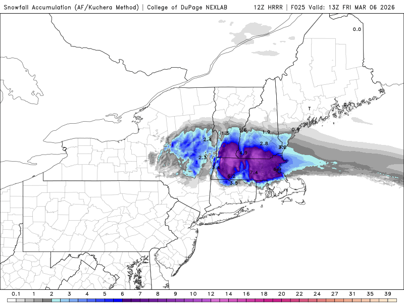
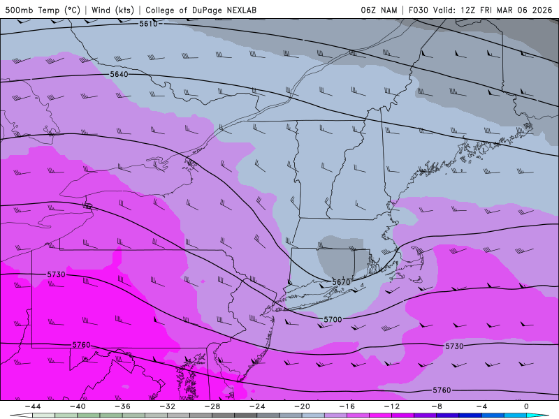
Will CoastalWx eek out another 6" "VIOLENTLY BEAUTIFUL" wet snow pasting? 12z HRRR thinks so! So borderline. The issue is between 850 and 700. Right on the fence for so much of the nrn 1/2 of MA. 1000-850 thickness ok. One thing of note that may make ern MA down to Weymouth a "surprise," the sfc pressure never falls below about 1028 mb at BOS, which very high for a sig snowfall/QPF event. And you can see the sfc high pressure wedge holds strong and tries hard to push SW in ern MA during the entire event. Another thing, such high heights and thicknesses, so more moisture. In fact, the 12z HRRR shows a max of 1.80" rain/LEQ not far S of ORH. That is quite impressive for what amounts to a meager 1019 mb sfc low SE of ACK! And yet another thing, it is quite strong mid-upper level trof (500-250) that passes right over SNE, cold pool and all, and you can see what happens later in the event over ern MA (esp. NE) as the pcpn "hangs back" a bit. Sim IR shows a pseudo-common head. Just sayin' that given high QPF, the ideal track of the 500 trof, and the borderline temps, there could be a "wild turkey surprise" here for more snow than explicitly shown! Edit: And the peak of the pcpn is overnight, which makes an enormous difference for accumulating snow this time of year and give just a few less tenths of a degree to the BL!
-
And forgettable for CoastalWx as well GHG *yawn*! Worst than 12/12/1992 when he lived in Brockton?! I got 22" in N Woburn that was 100% wet snow, most ever I had seen from single storm.
-
The big bust PHL-BOS storm! One of the first big mega hype media storm starting 5+ days out I think. I had 22" of wet snow in N Woburn MA w/ crazy vertical accumulations on power lines. Also, first time I noticed when you dig into wet snow that deep, esp. when cloudy, you see a blue tinge from the high moisture content.
-
Good enough for CoastalWx standards? Reliable report of 5.9" In FIT (not in PNS yet). That is very respectful for such a "minor" event. And now widespread 1/4" glaze in parts of SNE. This seals the pack so it is "protected" a bit longer!
-
What do all say about the 41" report in Fall River? https://x.com/snewengweather/status/2026098368804487556 I see it plotted on the JDJ map, but it does not seem to jibe w/ surrounding totals. Also, NWS BOX did not included it in their PNS. Looking at the photos, it is a tape measure and those can bend at the bottom against a solid surface, or since several inches of snow was on the ground prior, is that accounted for? This reminds me of the Bridgewater MA 41" report in the Bliz of '05 (I think that was the storm). Every time I brought that up to CoastalWx, he would vehemently deny that actually fell there! LOL.
-
Thanks, will email WFO GYX for the complete top 20 list of PWM storm surges.
-
It appears by the end of this year, Rio de Janeiro will be made a TCAC for the South Atlantic Basin. https://x.com/frontierfcst/status/2028252178335310228 Now only if we could get a TCAC for the Mediterranean Sea, which clearly has shown that it has bona fide TCs, along w/ many subtropical cyclones. Geopolitical borders/areas are a construct of human society. The atmosphere does not care one bit about that. It does what it does regardless. This system is I think the strongest Mediterranean Sea TC on record - Ianos Sep 2020. https://en.wikipedia.org/wiki/Cyclone_Ianos tcac.pdf
-
"Don’t do it" 2026 Blizzard obs, updates and pictures.
vortex95 replied to Ginx snewx's topic in New England
Yes, March 1997 was cold, windy, w/ a couple of days of decent snow squalls. Lots of low-topped CBs I recall in the distance! -
"Don’t do it" 2026 Blizzard obs, updates and pictures.
vortex95 replied to Ginx snewx's topic in New England
And don't throw in the towel yet for this winter. See 1996-97, which was lame through the end of March, and then one of the best ev-A blockbusters occurred for SNE for April Fool's. That one storm put brought me from an well-below avg snowfall winter to just above avg in one fell swoop. Even CoastalWx was wicked impressed, and it rates as his all-time fav snowstorm!


