
Brian D
-
Posts
2,624 -
Joined
-
Last visited
Content Type
Profiles
Blogs
Forums
American Weather
Media Demo
Store
Gallery
Everything posted by Brian D
-
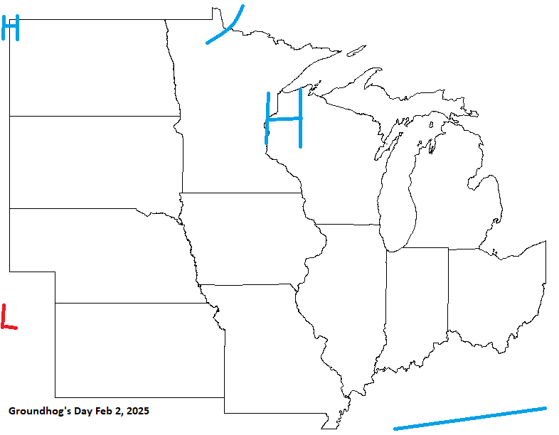
Groundhog's day looks fair, and rather cold. Probably the coldest wx of the winter so far with what looks like a trough digging in starting late Jan into early Feb. That should get the LES engine roaring.
-
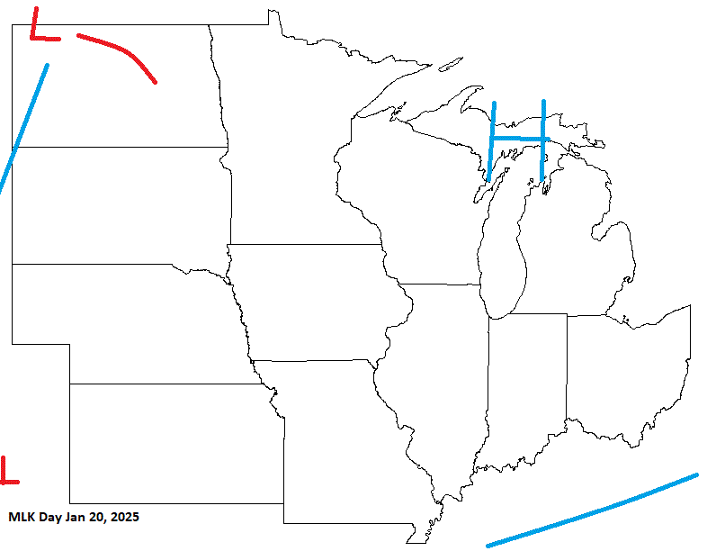
Another year on tap. Time sure is flying. The New Year's Day forecast is coupled with New Year's Eve Day in the "Holiday Forecasts 2024" thread. Starting off with MLK day, it looks like a ridge of HP will be over the sub bringing in chilly wx, and LES potential for some.
-
Windy am here in NE MN. Gusts up to 50+ for some areas, and even a 69 mph gust followed by a 61 mph gust reported near Silver Bay on the shoreline at 4:40 & 4:50 am. The winds are slowly dying down currently.
-
A decent call here except my timing was a little quick. Nothing in the S areas except the boundary, which is dry. And there will be some LER/S across the Lakes during the day into the overnight as HP is moving into region on a N to NW flow.
-
Just scattered showers up my way. Nothing too robust, unfortunately. Wind advisory out for my area starting from 2 am thru 10 am tomorrow. 40-50 mph gusts anticipated.
-
Early data in for Oct. Very warm, especially for the NW half of the sub. 5 & 10 yr trend charts shown respectively.
-
0.84" of precip for Nov so far, and more this weekend. A wet Deer season opener here in MN is on tap this weekend. Glad to see more rains coming. It'll soak in, and stay there this time of year. Although WI has turned into more of swamp with all the precip they've had this year. Crying "Uncle". Been tough for some areas. Temps very pleasant for early Nov, which is nice. Considering the price of natural gas already, the less cold the better for the heating bill.
-
0.52" from the last couple days. More on it's way this aftrn. Nothing like to my S, but I'll take it.
-
Overcast, wet wx starting yesterday, and going through tomorrow. Need the precip. Just soaking showers, but that'll work as it keeps coming in waves. Only around a 1/4" so far, but a nice batch moving in shortly.
-
Looks like that energy running the boundary will be happening, causing Election day to be wet. Get out and vote if you haven't already.
-
Not uncommon, but this decade is humming along with extremes. I keep updated records of the various long period stns in our region, although haven't updated Oct stats yet. Here's what 5+ from 2nd place High Min daily records with 10+ in the mix noted for Chicago.
-
Not a fan of changing clocks, but tonight is the night. Dark at 5pm sucks. Worse N of me so I guess can't complain too much.
-
Looks like Election day will be a little wet for some. My forecast in the Holiday Thread looks close. Nov 9 starts the MN Deer Hunting opener (aka rifle season, as there is a bow season as well), and I'm expecting LP/front in the region with HP pushing in over the weekend.
-
Duluth picked up 1.6" of snow yesterday. Looks like a swath of 1-4" across E MN into N WI, and the W UP MI. Just a wet, slushy event here in town. The grass barely had any on it, and my deck. Very light precip event at 0.14". TH ended with 1.31" for the month. Currently running at 2nd driest Sept/Oct with 1.37" (1.17" 1948). TH co-op hasn't been taking temps since April because the sewage plant has been under construction. The MMTS/Nimbus will be reinstalled when that's completed. Duluth ended the month with an avg of 50.1 (8th warmest), and 1.05" precip. Sept/Oct's 1.36" is currently 5th driest. Duluth is at 57.1 for Sept/Oct edging out 56.9 1963 for warmest Fall so far. TH Agates high school football team made it to the Section 7AAA finals, but lost to Pequot Lakes last night 35-15. They played at the UM of Duluth field. They had a good year. It was very cold, and the snow ended around game time. Injuries, and a slew of penalties hurt them, but a loss is a loss. Pequot Lakes was their only loss in the regular season, as well.
-
Picked up 0.47" of rain during the pre dawn hours this morning. Later tonight into tomorrow should be a good douching with some white stuff for the ridges. Typical late Oct wx.
-
Decent call here. System quickly heading NE through the Lakes bringing much needed precip, and some snow IMBY.
-
We shall see. WSWtch from 7am-4pm tomorrow. During the day, will be hard to get accum with warm ground, and marginal temps. It's going to have snow pretty hard to get up to 6" in that short period of time. If this were overnight, it would be in the bag, I think, with possibly a little more. Just a cold rain for me here on the shore which is typical this time of year.
-
And so it begins! Looks like up to an inch of precip possible for me in the next couple days. That would be nice. Higher terrain getting in on some snow action, as well. Just a mix here in town.
-
0.28" of rain from that complex that moved through last night. Up to 0.84" for the month, and another shot at some rain next week.
-
Love the older trees along the streets. We have many here in TH like that, too, except they have been redoing the sewer lines, and streets every year for the past few years. In doing so, they cut down the old trees, and it just makes it so open, and I don't care for that. It'll be decades for many of our streets to look like that again. Back in the 70's/80's when Dutch Elm disease hit, and they all had to be cut down, it was the same way. Thankfully, many maples were in the mix, so it wasn't as bad.
-
36" in TH. 36.9" at DLH. 33" in Brimson. 34.5" in Superior, WI. Interesting that near shore, and inland were pretty much the same. I was working construction that Fall after getting out of the Army that summer, and I remember the snow started falling Halloween evening (on a Thursday). The 1st wave wasn't that bad (12"), and ended Friday am, but when the main wave came in later Friday aftrn as the bombing LP was moving N, it just hammered the hell out of us into Saturday am. (24"). 5.14" SWE, so very wet snow with 30-50+ mph winds. Big drifts. BTW, the LP off the East Coast was the weakening "Perfect Storm" from a couple days prior. https://www.meteo.psu.edu/ewall/NARR/index.html https://gifmaker.me/
-
That storm was definitely historic. That set a bar for storms around the end of Oct into early Nov. I partied hard during that one.
-
Just keep getting spits of rain. Other than a week ago when I saw not quite a 1/2", this Fall has been very dry. Only 0.62" since Sept 1. Temps running seasonable to mild. Need some good winds to knock off the dying leaves. High school football playoffs underway this week. Two Harbors played well this year (7-1). They got a 1st round bye at 2nd seed. They play this Sat. My grandson has done well this year. Hopefully they will make it to state, but that's a tough climb. He did go to state in track earlier this year, tho.
-
Very nice Indian summer wx these next few days. Unfortunately no real precip in the picture, just some shower chances. I think Nov will have a better shot at significant precip chances. Lord knows we need it.
-
Thought I'd add Election Day into the mix this year. Looks like a front will be moving through, and possible energy with it. If that happens, a little wet wx on tap for some, but the front itself shouldn't be a big issue. Make sure to vote if you haven't already.

