MN Transplant
-
Posts
17,659 -
Joined
-
Last visited
Content Type
Profiles
Blogs
Forums
American Weather
Media Demo
Store
Gallery
Everything posted by MN Transplant
-
Feb 22nd/23rd "There's no way..." Obs Thread
MN Transplant replied to Maestrobjwa's topic in Mid Atlantic
3.6” total, sticking to everything. 0.89” precip, 0.55” after the final changeover to snow which means ratios were even worse than we were worried about. -
Feb 22nd/23rd "There's no way..." Obs Thread
MN Transplant replied to Maestrobjwa's topic in Mid Atlantic
Still 33/34 at DCA. Wonder if they’ll report much of anything. -
Feb 22nd/23rd "There's no way..." Obs Thread
MN Transplant replied to Maestrobjwa's topic in Mid Atlantic
Surprised you are still that warm. I’m 31.1. Do have to say, this is still low ratio stuff. -
Feb 22nd/23rd "There's no way..." Obs Thread
MN Transplant replied to Maestrobjwa's topic in Mid Atlantic
Sounds like fun. I’m in. -
Feb 22nd/23rd "There's no way..." Obs Thread
MN Transplant replied to Maestrobjwa's topic in Mid Atlantic
1.25” so far. Looks nice.
-
Feb 22nd/23rd "There's no way..." Obs Thread
MN Transplant replied to Maestrobjwa's topic in Mid Atlantic
31.6 and moderate to heavy snow. Looking good. -
Feb 22nd/23rd "There's no way..." Obs Thread
MN Transplant replied to Maestrobjwa's topic in Mid Atlantic
32.7. Just starting to stick on mulch and elevated surfaces. -
Feb 22nd/23rd "There's no way..." Obs Thread
MN Transplant replied to Maestrobjwa's topic in Mid Atlantic
Temp seems to have turned over. Down to 34.5 and wet snowflakes. -
Feb 22nd/23rd "There's no way..." Obs Thread
MN Transplant replied to Maestrobjwa's topic in Mid Atlantic
We were all joking about DCA reporting a low total, now watch them get plastered. -
Feb 22nd/23rd "There's no way..." Obs Thread
MN Transplant replied to Maestrobjwa's topic in Mid Atlantic
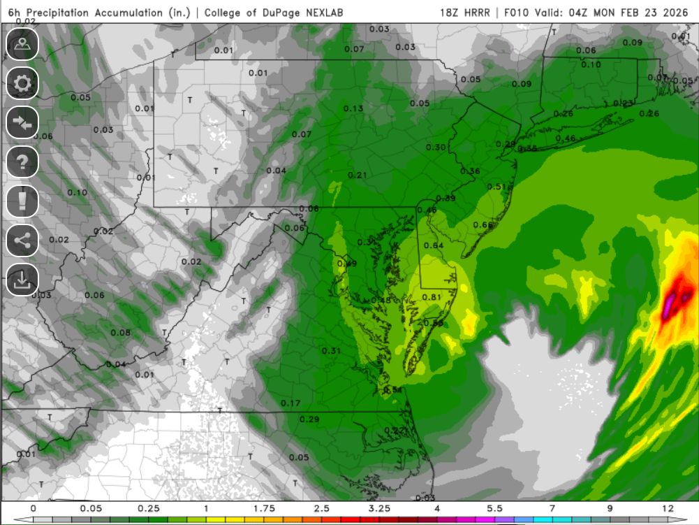
18z HRRR, 6hr precip 5pm-11pm
-
Feb 22nd/23rd "There's no way..." Obs Thread
MN Transplant replied to Maestrobjwa's topic in Mid Atlantic
18z HRRR has the inverted trough axis fractionally east. I clearly approve of the location. -
Feb 22nd/23rd "There's no way..." Obs Thread
MN Transplant replied to Maestrobjwa's topic in Mid Atlantic
35.6. 0.25" precip on the day. Got my hockey high this morning, now the doldrums until the snow starts this evening. -
Feb 22nd/23rd "There's no way..." Obs Thread
MN Transplant replied to Maestrobjwa's topic in Mid Atlantic
Gold! USA! -
Feb 22nd/23rd "There's no way..." Obs Thread
MN Transplant replied to Maestrobjwa's topic in Mid Atlantic
The locations show if you go sideways to landscape mode. -
Feb 22nd/23rd "There's no way..." Obs Thread
MN Transplant replied to Maestrobjwa's topic in Mid Atlantic
Yeah, that’s exactly what’s happening. Rates temporarily win but it is still way too warm overall. 34.9 -
Feb 22nd/23rd "There's no way..." Obs Thread
MN Transplant replied to Maestrobjwa's topic in Mid Atlantic
Looks like the latter. Got some snowflakes in that heavier band, but back to rain now. -
Feb 22nd/23rd "There's no way..." Obs Thread
MN Transplant replied to Maestrobjwa's topic in Mid Atlantic
I have partially melted snowflake mixing in at 36.0 degrees -
Feb 22nd/23rd "There's no way..." Obs Thread
MN Transplant replied to Maestrobjwa's topic in Mid Atlantic
I certainly like the placement of the inverted trough on the models. But, I think anyone rooting for the 3km NAM early changeover outside of the favored areas is wishcasting. 12z sounding from Dulles. 72403 IAD Sterling Observations at 12Z 22 Feb 2026 ----------------------------------------------------------------------------- PRES HGHT TEMP DWPT RELH MIXR DRCT SKNT THTA THTE THTV hPa m C C % g/kg deg knot K K K ----------------------------------------------------------------------------- 1005.0 93 3.4 1.9 90 4.39 330 5 276.2 288.3 276.9 1000.0 130 4.2 0.3 76 3.93 65 3 277.4 288.3 278.0 999.0 138 4.2 0.2 75 3.90 67 3 277.4 288.3 278.1 956.0 493 1.5 -0.6 86 3.85 140 10 278.2 289.0 278.9 938.0 646 0.3 -0.9 91 3.82 130 11 278.6 289.3 279.2 925.0 759 -0.5 -1.2 95 3.80 150 11 278.8 289.5 279.4 923.0 776 -0.7 -1.4 95 3.76 150 12 278.8 289.3 279.4 910.0 889 -1.3 -1.9 95 3.67 120 14 279.3 289.7 279.9 884.0 1120 -2.5 -3.0 96 3.49 130 10 280.4 290.4 281.0 883.0 1129 -2.5 -3.0 96 3.49 133 10 280.4 290.4 281.0 874.0 1211 -1.9 -2.2 98 3.74 156 10 281.9 292.6 282.5 859.0 1348 -2.8 -2.9 99 3.62 195 11 282.4 292.7 283.0 850.0 1432 -3.3 -3.3 100 3.54 215 8 282.7 292.9 283.3 841.0 1516 -3.7 -3.7 100 3.47 214 8 283.1 293.1 283.7 825.0 1668 -3.5 -3.5 100 3.60 212 9 284.9 295.3 285.5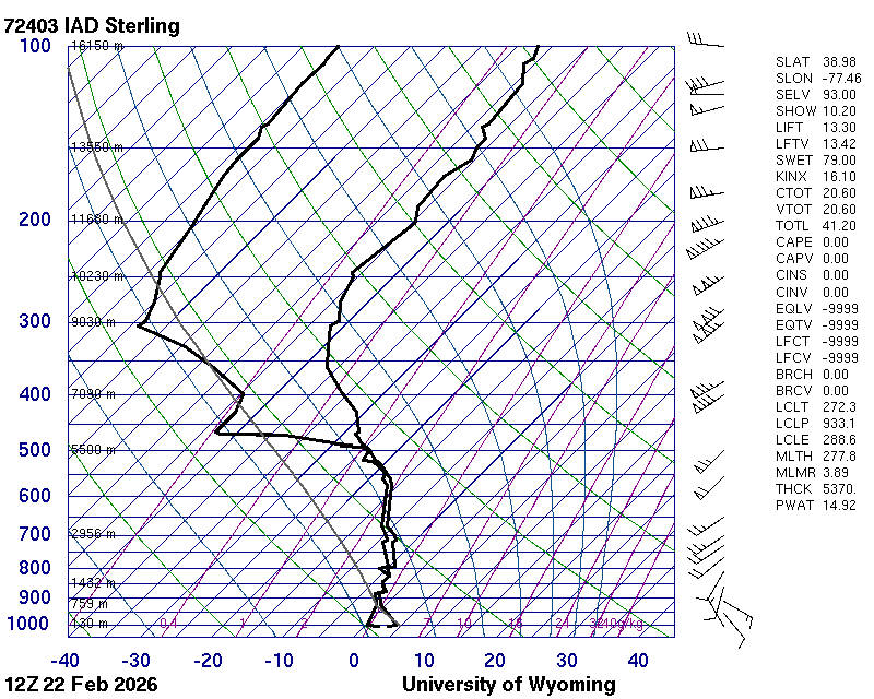
-
Feb 22nd/23rd "There's no way..." Obs Thread
MN Transplant replied to Maestrobjwa's topic in Mid Atlantic
Rain. 36.3 -
Feb 22nd/23rd "There's no way..." Obs Thread
MN Transplant replied to Maestrobjwa's topic in Mid Atlantic
39/28 -
Feb 22nd/23rd "There's no way..." Obs Thread
MN Transplant replied to Maestrobjwa's topic in Mid Atlantic
I don’t think I’ll break top-5 since 2016. -
2/22-23 "There's no way..." Storm Part 2
MN Transplant replied to Maestrobjwa's topic in Mid Atlantic
Not sure about moderate. We are tacking on 0.01 to 0.02”/hr from 3am on. -
2/22-23 "There's no way..." Storm Part 2
MN Transplant replied to Maestrobjwa's topic in Mid Atlantic
This is such a weird model battle. There's no doubt that the GFS "won" by catching on to the synoptics. But it was terrible for sensible weather, first spitting out monster amounts inland and then insisting that the main part of the event was during the day on Sunday. -
2/22-23 "There's no way..." Storm Part 2
MN Transplant replied to Maestrobjwa's topic in Mid Atlantic
I bet those get bumped by about an inch by the end of the day. -
2/22-23 "There's no way..." Storm Part 2
MN Transplant replied to Maestrobjwa's topic in Mid Atlantic
Doing some estimation, it looks like 0.5"-0.6" for a lot of us, which is a nice result and lands in the middle of the more conservative models and the NAMs.