

McHenrySnow
-
Posts
537 -
Joined
-
Last visited
Content Type
Profiles
Blogs
Forums
American Weather
Media Demo
Store
Gallery
Posts posted by McHenrySnow
-
-
If temps today are any indication, I'm going to be more concerned than I was about temps.
-
I keep thinking back to January 2019, the week of the extreme cold from the displaced polar vortex and remember a system that had what would normally be a garbage track for Chicago surprise us with an all snow front end thump. I believe we got 3 or 4" in the city. It warmed up above freezing and we had drizzle the rest of the day and then the arctic front eventually made it through the area the next day or so?
Anyhow, this reminds me of that somewhat. Not necessary the atmospheric setup, but the heavy wet snow preceding the arctic blast.
-
 4
4
-
-
2 minutes ago, purduewx80 said:
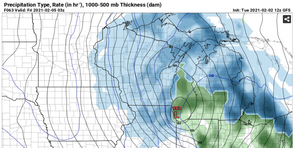
Pretty big changes upstairs (see below), but it didn't really translate to much difference at the surface. The splotchiness of snow accumulations in these parts is indicative of dynamic cooling. Probably going to have to rely on that south of ~88/290 as others have mentioned. Don't think we should disregard that scenario given the ingredients showing up on a lot of guidance: steep lapse rates, 500-250mb left exit region dynamics, highly focused WAA, but air temps will almost certainly be above freezing for at least a few hours S/SE of wherever the surface low ends up tracking. Whatever snow ended up falling in those areas may not accumulate on roads (unless it's heavy) but could add to the snow depth a bit.
Yeah, the nice thing is snow will stick to snow, so even if we wouldn't see much on paved surfaces, it might be enough to counteract melting and/or increase total depth.
-
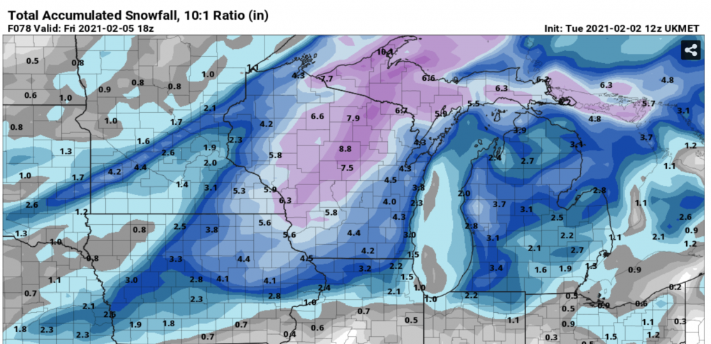
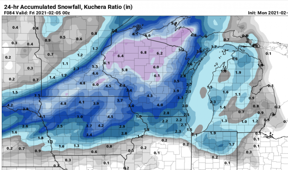
3k NAM actually increased totals across LOT.
-
No major changes on the 18z NAM it appears.
-
1
-
-
Hate to say it, but I do think the Ukie makes more sense right now. I have all of the same concerns Hoosier pointed out.
-
1
-
-
4 minutes ago, WestMichigan said:
Early on you are correct, but any time after 84 hours or so any place down wind of the Great Lakes will wind up being the winner. Looks like the lakes will finally produce snow in many of the normal LES regions.
Oh, I mean in the Chicago metro area only.
-
Might the NW burbs win this round? @Cary67 and I would appreciate it.
-
1
-
-
Low party at @A-L-E-K's house Thursday night per 12z GFS.
-
6 minutes ago, A-L-E-K said:
rgem still a hit
A very good hit for the vast majority of LOT.
-
1 minute ago, ILSNOW said:
Agree there are now 2 precip maxes 1 which did jump nw and 1 over chicago metro which the 6z had .2 the 12z now has .5 to .7

Yeah, QPF shows a bigger difference than low placement.
-
3 minutes ago, Baum said:
I'm not a great model output guy. But I'm not seeing that. In fact, snowshield here minus the actual low pressure seems to have improved versus 00Z, Again, surging arctic fronts with a a wave riding along it can over perform nicely beyond model output....sometimes. This looks like it has this make up from a weenies blind eye. 3K even better. Not sure it matters at this long distance.
It's NW some, definitely not "big time." And yes, temps are cooler and shows much more snow across the area than 0z. Though the 3K totals around hour 60 make more sense than the 12k imo.
-
The RGEM run looks nice if you just look at the snow map. Conceptually, it doesn't make a lot of sense.
-
11 minutes ago, Baum said:
looks good for areas up north. Can't over react too much too any one model run. Seen these set ups surprise many times as the front races in and squeezes out any residual moisture. And yes, were talking an inch or two in a flash freeze type set up and not a large scale moderate event. But I like those type events as a winter weather fan. They can't all be 10" snowstorms.
None of them have been here.
I wasn't expecting a snowstorm and was happy when guidance strayed from the mega cutter idea. Even if the low passes overhead, it's better than going through Iowa and we get to save most of the snow cover. I just hope we can squeeze an inch or two out to freshen things up for the bitter cold to follow. We'll see how it turns out. Went above freezing today actually, so definitely ready for the cold.
-
1
-
-
The idea of some snow from this before the arctic blast was nice while it lasted.
-
 1
1
-
-
Just now, RCNYILWX said:
On the range of possible outcomes, certainly an interesting solution to add into the mix. That run has a sharper digging northern s/w able to phase with more southern routed energy and the whole thing quickly goes neutral to negative tilt.
I'd place it on the lower probability end of the spectrum to get that well timed phase, though we'll see shortly on the rest of the incoming 12z operational and ensemble cycle if that idea gets any more than minor member support.
Sent from my SM-G965U using Tapatalk
Just need it a bit further east and game is on. An awful lot to ask for, though.
-
2
-
-
2 hours ago, KokomoWX said:
The GFS v16 snaps back by the end of the run to 50's and 60's across IL, IN, & OH. Hopefully the brutal cold will not be sustained.
Yes, who doesn't prefer 50s and 60s in February in a thread composed largely of snowlovers? lol
-
1
-
 2
2
-
-
RGEM similar to NAM. Most of us are above freezing, but the snowpack melting should be countered by any new additional snow at least.
-
1
-
-
6 minutes ago, ILSNOW said:
84hr 12z NAM showing a small refresher before the vortex visits.

I definitely think this is best case scenario.
-
1
-
-
7 minutes ago, SchaumburgStormer said:
Another McHenrySnow Quality Post™
As opposed to yours? Got to love the childishness and pettiness of most of you on here. Someone can't complain about a lack of snow without you jumping down their throat, but then you can complain because somebody posts too many maps. I get the feeling most of you were bullied as children and now have decided to become the bullies anonymously.
-
3
-
1
-
-
8 minutes ago, SchaumburgStormer said:
Seriously. Pivotal allows you to create a gif comparing models. If you are going to post 1.75 million useless maps, at least combine them into one image.
Seriously, you don’t have to quote the post and include every one of the maps you’re complaining about in it.
-
4
-
 4
4
-
-
3 minutes ago, Baum said:
solid light snow after about 15 mins of mixed sleet. Probably a bit ahead of schedule. and it's blowing and whipping. Sure does not have the character of a super wet snow at this point.
Same here. I took a nap and woke up quite surprised to see the action had started. Already a DAB+ out there. Let the games begin.
-
4 minutes ago, RyanDe680 said:
Lake effect seems overdone?
Lake effect IS overdone.
-
5 minutes ago, pondo1000 said:
It really has been impressive.
Consistency doesn't equal accuracy.
-
4
-
2
-


Feb 3rd - 5th Potential strong stm threat
in Lakes/Ohio Valley
Posted
I understand that. I also understand that we're blowing past forecast highs at noon.