

McHenrySnow
-
Posts
537 -
Joined
-
Last visited
Content Type
Profiles
Blogs
Forums
American Weather
Media Demo
Store
Gallery
Posts posted by McHenrySnow
-
-
21 minutes ago, ChiTownSnow said:
I recall in the past, that little "mesolows" can set up out over the lake and pump moisture back into the region. Are these small/local features generally picked up on models? Or are these a as it happens type of thing?
Hi-res models can pick it up, but they are notoriously difficult to forecast.
-
3 minutes ago, Chicago Storm said:
That will be a question for @RCNYILWX, as LOT would handle that decision.
Any lake effect Wednesday and Thursday will be largely due to the system passing south of us and not the system tomorrow and Tuesday, so I can't fathom doing a 4-day total for something like that.
-
 1
1
-
-
Just now, hlcater said:
I’m sure we will, but as I said last night, I was hoping for a shot at some truly impressive snows, so the trend towards something more garden variety (7-8”) is pretty crummy. Especially when considering the potential that was on the table.
Understandable, but you've had more than double most of the Chicago posters - and, without the lake, my concern is the drying trend on this side of the Mississippi. You're at least close enough to the better dynamics that you might manage more than you expect.
-
0.25" here this morning, all falling from around 8 to 9 am. Wasn't expecting a big total, by any means, but the models had been ticking up all day yesterday. Dry air won out.
-
 1
1
-
-
10 minutes ago, Hoosier said:
Are we gonna consider Mon/Tue as the "storm total" at ORD? Not that it's a big deal but let's say 9" occurs on Mon/Tue and then 1.3" or something on Wed/Thu with lake effect. That would bring the 4 day total to 10.3" but it would feel cheap to call that a 10" storm.
I'm betting we won't have to worry about that.
-
1
-
-
Just now, hlcater said:
Euro is nasty. Forecasting half the totals that were originally forecast yesterday, even when including the first system. That’s a pretty remarkable drying on that model. I’d love for the GFS to be right, but it stands alone in bringing solid snows to the Mississippi. The trends have really screwed E IA in the big snow department.
You've done well on every storm, I'm sure you'll do pretty well on this one. I wouldn't worry too much if I were you.
-
Oof. Shouldn’t have stayed up for that.
-
1 minute ago, NEILwxbo said:
First thoughts on accumulations for LOT area. Could change.
Overall looks good to me. I'm beginning to doubt doubt digits, though localized 10" especially further west is certainly possible.
-
1
-
-
Just now, mimillman said:
It sucks in November and December. We get rainers/poor accumulation while the suburbs cash in. ORD routinely will print 2-3” higher than the Loop in December and in November, that could be closer to 6”. We start to win out in late Jan - March, but overall I’d prefer to live northwest.
Was in Bridgeport during the November 2018 "blizzard" - that and the snowstorm in November 2015 were heartbreakers for people who actually lived in the city (let's face it, O'Hare isn't the city).
-
2
-
-
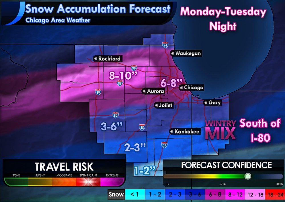
1 minute ago, McHenrySnow said:
This shows the actual storm total best as the "total" accums add an inch to inch and a half across much of northern LOT from tonights snow.
You can also see the lake's influence very well. Maybe too well for parts of McHenry, Kane, and DuPage.
-
1 minute ago, mimillman said:
These are all fine solutions. I consider myself very lucky to be in the game for a 6”+ event and the south central Iowa weenies can enjoy their moment of glory.
I’m hoping tomorrow we can get a bit more QPF out of this further East. Still have a whole day to sort that out until people start posting the HRRR and it’s Madison blockbuster early scenarios
You have the lake to at least pad totals by a couple inches, which is always nice. I can't imagine living in the loop and loving snow the past few years. It was bad enough in Bridgeport, but we often had better accums than the loop.
-
1
-
-
This shows the actual storm total best as the "total" accums add an inch to inch and a half across much of northern LOT from tonights snow.
-
Just now, Baum said:
I'm 4 cocktails in when does the euro hot? * hit
Midnight or so.
-
Just now, Cary67 said:
LOT's decision to wait on issuing headlines seems prudent
They'll issue one in the morning, little doubt about that.
-
 1
1
-
-
Just now, Hoosier said:
Most likely neither of those will happen. I'm rather bullish on Iowa (always bet on banding) but wouldn't go 2+ feet without more support for it.
Oh, certainly not. Well, I hope the 6-8" across N IL verifies and, even though it's been an Iowa winter, there's no chance 30" falls.
-
GEM drops 30" in S Central Iowa and then peters out to 6-8" across N IL.
-
1
-
1
-
-
1 minute ago, Malacka11 said:
Honest to god between the Para and the new GFS I'd ride the para all day
Plus, hasn't the Euro been trending this way? This storm is the Euro's turf, I'll ride that thing till I die
Well, I certainly can't argue that the new GFS is better.
-
1
-
-
Just now, Malacka11 said:
My psychic abilities say otherwise, my friend.
Has the Para ever been correct? I mean, I think it has gotten better, but it's still been pretty awful.
-
1
-
-
Just now, Malacka11 said:
I know you're just being sarcastic but honestly this is the exact solution we need.
The one we need, certainly, but not the one we'll get.
-
1
-
-
1 minute ago, chuckster2012 said:
I hear you, guy. I'm down here west of Cincy and this year has been terrible. I sometimes think the OV should have its own regional page. Our weather is so different from the Lakes region..
We've only had 50% of the snow we should have had to date. I understand your agony and I know you'd be thrilled to have what little I've seen, but considering the climate differences, not a big difference. We've both had a bad winter. This may change things our way here and there is still time for you guys further south. Biggest snowstorm I've been in was March 4-5, 2015 in Kentucky.
-
2
-
-
I never expected a watch before tomorrow morning. LOT is usually more conservative than both DVN and MKX and I think tomorrow morning is plenty of time.
-
2 minutes ago, madwx said:
heads up that about 2" of that on the NAM from Dekalb to the west and north is from the wave overnight
Yep, seems models are being a little more generous tonight/early tomorrow in N IL.
-
1
-
-
Just now, Hoosier said:
Last 3 runs of the NAM ending at 12z Tuesday. Context matters.
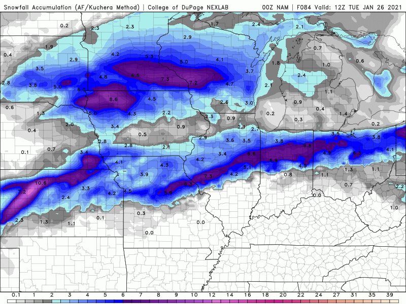
As I said, I like the trend. Said it so many times.
-
Just now, RCNYILWX said:
I think we're still a bit far out to be concerned about the finer scale details of a particular operational run. There's a pretty good consensus developing on the big picture, which is I-80 and north favored and northern tier looking much better.
New ECMWF in a vacuum is less favorable with southward extent, though I'm sure when the ensembles roll we'll see wiggle room within the general consensus of the EPS, that's been rock solid consistent. Takeaway from the prolonged mid-level forcing on Tuesday is it would be a nice way to tack on higher ratio fluff with 850s down around -10C.
Sent from my SM-G965U using Tapatalk
Couldn’t agree more.
-
 1
1
-

Jan 24-26th Potential Something Part 2
in Lakes/Ohio Valley
Posted
4" is my current guess for my backyard. Disappointing drying trend. 0z runs will be important, can we stop the bleeding?