

McHenrySnow
-
Posts
576 -
Joined
-
Last visited
Content Type
Profiles
Blogs
Forums
American Weather
Media Demo
Store
Gallery
Posts posted by McHenrySnow
-
-
Just now, Baum said:
I'm 4 cocktails in when does the euro hot? * hit
Midnight or so.
-
Just now, Cary67 said:
LOT's decision to wait on issuing headlines seems prudent
They'll issue one in the morning, little doubt about that.
-
 1
1
-
-
Just now, Hoosier said:
Most likely neither of those will happen. I'm rather bullish on Iowa (always bet on banding) but wouldn't go 2+ feet without more support for it.
Oh, certainly not. Well, I hope the 6-8" across N IL verifies and, even though it's been an Iowa winter, there's no chance 30" falls.
-
GEM drops 30" in S Central Iowa and then peters out to 6-8" across N IL.
-
 1
1
-
 1
1
-
-
1 minute ago, Malacka11 said:
Honest to god between the Para and the new GFS I'd ride the para all day
Plus, hasn't the Euro been trending this way? This storm is the Euro's turf, I'll ride that thing till I die
Well, I certainly can't argue that the new GFS is better.
-
1
-
-
Just now, Malacka11 said:
My psychic abilities say otherwise, my friend.
Has the Para ever been correct? I mean, I think it has gotten better, but it's still been pretty awful.
-
1
-
-
Just now, Malacka11 said:
I know you're just being sarcastic but honestly this is the exact solution we need.
The one we need, certainly, but not the one we'll get.
-
1
-
-
1 minute ago, chuckster2012 said:
I hear you, guy. I'm down here west of Cincy and this year has been terrible. I sometimes think the OV should have its own regional page. Our weather is so different from the Lakes region..
We've only had 50% of the snow we should have had to date. I understand your agony and I know you'd be thrilled to have what little I've seen, but considering the climate differences, not a big difference. We've both had a bad winter. This may change things our way here and there is still time for you guys further south. Biggest snowstorm I've been in was March 4-5, 2015 in Kentucky.
-
2
-
-
I never expected a watch before tomorrow morning. LOT is usually more conservative than both DVN and MKX and I think tomorrow morning is plenty of time.
-
2 minutes ago, madwx said:
heads up that about 2" of that on the NAM from Dekalb to the west and north is from the wave overnight
Yep, seems models are being a little more generous tonight/early tomorrow in N IL.
-
1
-
-
Just now, Hoosier said:
Last 3 runs of the NAM ending at 12z Tuesday. Context matters.
As I said, I like the trend. Said it so many times.
-
Just now, RCNYILWX said:
I think we're still a bit far out to be concerned about the finer scale details of a particular operational run. There's a pretty good consensus developing on the big picture, which is I-80 and north favored and northern tier looking much better.
New ECMWF in a vacuum is less favorable with southward extent, though I'm sure when the ensembles roll we'll see wiggle room within the general consensus of the EPS, that's been rock solid consistent. Takeaway from the prolonged mid-level forcing on Tuesday is it would be a nice way to tack on higher ratio fluff with 850s down around -10C.
Sent from my SM-G965U using Tapatalk
Couldn’t agree more.
-
 1
1
-
-
Just now, Nelson said:
At the end of the day, if you have a met tag there are high expectations for the content you post. Most of us expect to see folks with met tags posting analysis and helping the rest of us understand better. I've seen neither from you. Mostly what I see is complaining. So if you're going to carry that met tag, and continue to complain and otherwise not provide any meaningful analysis, you should expect to get trolled. It really is as simple as that.
Their harassment started long before my tag, but thanks for the input.
-
 2
2
-
-
Just now, beavis1729 said:
Yep, agree overall. With that said, I think it's natural to be on edge and worry before the storm...thinking more about what could go wrong vs. what is likely to occur.
For northern LOT specifically...a couple days ago it looked like the initial/separate WAA snow tonight would be 2-3", now it may only be a dusting. So, that doesn't help. And, although I know op runs shoudl be taken with a grain of salt at range, there were a couple of op Euro runs showing close to 2 feet in northern LOT...which now is nowhere to be found. It's all relative.
")
Plus, if the storm really does weaken/shear out due to the effects of the block, it's likely to take a bit more southern route...which could favor the heart of the city instead of the northern areas. And, even if lake enhancement does occur, it may tend to favor the lakeside counties instead of McHenry and further west.
Again - all else being equal, I think there are still concerns in northern LOT, especially away from the lake...just like there are (different) concerns elsewhere in LOT and northern IN and into MI. That's why we need a true spread-the-wealth storm...so that everyone shares in the fun. I initially thought this storm might be it...but it appears to be transitioning to a narrow swath of heavier snowfall for a lucky few. And by heaviest, I mean 10"+. Not meant to complain...just human nature to be on edge a bit, given the snow drought that many of us have experienced over the last 2-3 years.
Be prepared to be piled on, but you’re used to it, I know.
-
1
-
-
Just now, SchaumburgStormer said:
Do you read what you write? You clearly picked 2 models here...
Proving that have the degree does not necessarily make a good forecaster
He said no models substantiated what I had said and that was not true.
ive acknowledged a good trend, I’m just being cautious. I’m sorry I can’t lend myself to weenie forecasting that suits you.
-
2
-
-
There is a concern with shear and unlike lake and cook, inland counties won’t benefit much if at all from the lake. There is absolutely nothing wrong about this statement.
-
Just now, SchaumburgStormer said:
I’m not sure why you, as a meteorologist, are cherry picking models which are outliers of the growing consensus to minimize the storm. Yes there are failure modes, but the preponderance of the evidence is showing a substantial event for N IL.
Am I writing in a foreign language? Or do you guys not bother to read. Where did I say I’m choosing one model over the other. I’ve repeatedly said my expectations have increased and I’m not worried about getting completely shafted like I once was.
-
1
-
-
5 minutes ago, mimillman said:
I’m sorry, there is not a SINGLE piece of operational guidance that supports northern LOT underperforming to the degree you’re suggesting. You’ve been a harbinger of doom from the very start of this event, have refused to acknowledge trends opposed to your view, and quite frankly it’s getting tiring. I respect a Met tag and I’m sure you’re speaking from experience, but for the love of god back it up.
You must be unaware of the NAM or RGEM. You must also have poor reading comprehension as I have repeated acknowledged trends are looking better. I’m not responding to you from here on out, you’re a troll.
-
2
-
-
Just now, SchaumburgStormer said:
I think northern LOT is in a 6” floor, high ceiling scenario. If the low remains intact a bit longer, there will be some sig totals. W LOT could jackpot by catching both the initial heavier band and any redevelopment for a secondary low.
Rockford almost always manages to do well no matter. Several models show a lower area of totals over Boone and McHenry due to the low shearing out and then the lake compensating for Lake and Cook. I’d be very happy with 6”, and, as I said, I’m becoming cautiously optimistic.
-
4 minutes ago, mimillman said:
I’m not harassing you, I’m disagreeing with you. If you’re going to continue to post unsubstantiated claims, expect the disagreement to continue.
Nothing I said was unsubstantiated.
-
1
-
-
Just now, mimillman said:

I’m really over your constant harassment.
-
1
-
-
Cautiously optimistic. Believe me, I would love to be proven wrong and northern LOT counties get at least 6", but I'm not sold. Lake County has the best shot, of course, thanks to lake enhancement/effect. I'd feel more comfortable if I lived 30 miles south.
-
1
-
-
2 minutes ago, Hoosier said:
Gotta say I don't remember many big snowstorms that hit you hard and screwed me. Talking downtown Chicago area and not well west like ORD. If I end up getting screwed on precip type, chances are it will find a way to screw you too. You never know though. I had not remembered seeing a synoptic storm like 2/24/2016 with that hellacious gradient between my location and the city, and it happened.
Oh, that was a nightmare. Please don't ever speak of it again! ha
-
50 minutes ago, RCNYILWX said:
Good evening y'all, just got back from the office a bit ago. Fun shift. Would be happy to answer any LOT specific questions if anyone has any. Regarding who's working in the lead up, I'll be back on evenings with Ratzer tomorrow through Monday and I expect I'll probably be doing evening update AFDs. Our midnight crew is the same as last night (Carlaw and Kluber) and it'll be them through the event. Dayshifts will be MTF and Petr. We should be in good hands. Glad that we stayed the course with the most consistent guidance in terms of our forecast lean and messaging in light of guidance trends already for 18z cycle. Here's to a good 00z cycle.
Sent from my SM-G965U using Tapatalk
I graduated with Kluber. We lived on the same hall in our freshmen dorm and were pretty good friends.
-
4
-
Jan 24-26th Potential Something Part 2
in Lakes/Ohio Valley
Posted
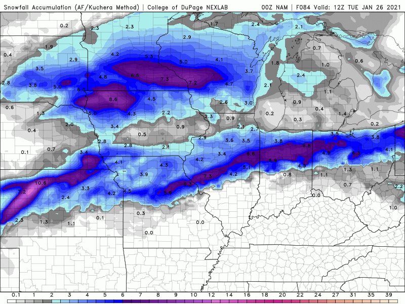
This shows the actual storm total best as the "total" accums add an inch to inch and a half across much of northern LOT from tonights snow.