

McHenrySnow
-
Posts
576 -
Joined
-
Last visited
Content Type
Profiles
Blogs
Forums
American Weather
Media Demo
Store
Gallery
Posts posted by McHenrySnow
-
-
14 minutes ago, mimillman said:
Sorry I had to. I'll stop now.
This has only been one-sided the entire time. Hope you got your rocks off now.
-
 1
1
-
-
4 minutes ago, mimillman said:
@McHenrySnow I guess our little kerfuffle wasn't so bad compared to what it could be..
I have no desire to participate in AngrySummons-type antics.
-
 4
4
-
-
Quote
We`ll get a quick break Tuesday and Wednesday before the next wave
of interest zips into the area Wednesday night/Thursday. Guidance
is in pretty good agreement with this next disturbance, all things
considered, and the presence of rather cold air aloft would
support a region of fairly steep mid-level lapse rates with this
feature. Things look cold enough for all snow with this
disturbance, so this is another one we`ll be keeping an eye on.
The good news is this will be quite a bit more starved of moisture
than its predecessor and fast-moving enough to limit residence
time over our area.
I'm going to have to have a chat with Ricky. That is not good news. (next storm, I know)
-
1
-
 1
1
-
-
Just now, ILSNOW said:
 '
'
Hard to bet against a storm slamming Iowa this winter.
-
1
-
-
1 minute ago, purduewx80 said:
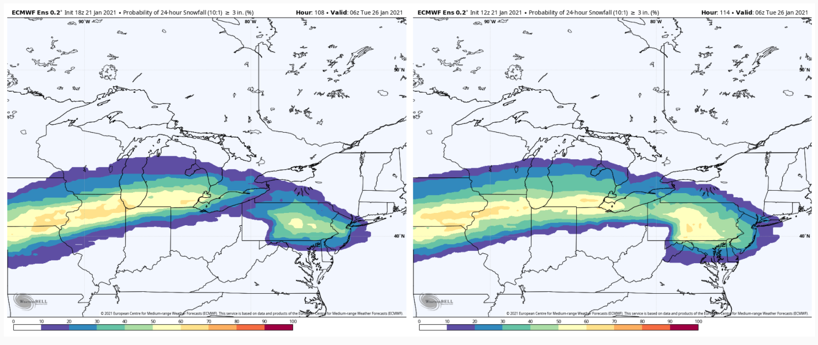
Based on 24 hour trends and 12Z guidance, I'd feel most comfortable in the area below for the swath of heaviest snow. If the block suppresses it any more, you can forget about any lake enhancement in IL. Some hints of colder air Monday night - Tuesday w/ a favorable fetch for true lake effect, but we'll see.
Agreed, though slightly further north. Chicago is definitely still in this, imo.
-
2
-
-
Just now, Baum said:
agreed. Couple of newbies got loose from pre school. Best not to engage. As I said two days ago...going to be a long slog.

That's fresh coming from you, but I agree, there's no reason to continue attacking posters simply because you disagree with their thoughts.
-
1
-
-
Just now, mimillman said:
What was the GFS? You were absent as that rolled out and only reappear to highlight runs that support this wall theory of yours.
I don't recall the GFS looking that great for the northern tier counties either. I have a job so I can't constantly follow your posts, forgive me.
-
Just now, mimillman said:
Is the writing back on the wall now? That wall must be getting very wordy
I'm not sure what your problem is, but yes, the Ukie is another strike against the far northern tier counties.
-
4 minutes ago, hawkeye_wx said:
12z UK is going to be south.
To say the least.
-
1
-
-
2 minutes ago, A-L-E-K said:
solid science
oh, is that what you've been trying?
-
1
-
 1
1
-
1
-
-
2 minutes ago, mimillman said:
I don't think they learn
I've learned not to get my hopes up. It's served me well.
-
1
-
-
Just now, ChiTownSnow said:
Keep in mind- this is long range for the NAM
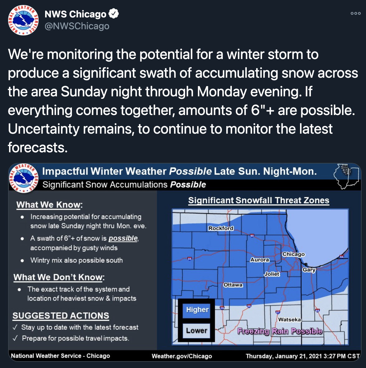
Oh, yes, NAM certainly doesn't factor into my thoughts at all at this point. Writing has been on the wall for the far northern tier. Even LOT agrees, they removed the likely wording from our forecast.
-
1
-
-
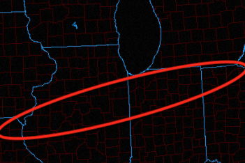
Hard not to believe this has completely slipped away from the northern tier of LOT counties. Chicago still in it and still a ways to go, but I've never felt good about my chances and sadly there hasn't been anything to convince me otherwise.
And now Sunday looks like a complete waste as well. Ah, the winter of my discontent.
-
1
-
-
Just now, ChiTownSnow said:
I'm surprised that LOT is so on board with 6+ . Confidence seems higher than normal
Certainly rare for them.
-
-
1 minute ago, purduewx80 said:
See probs I mentioned below. You’re taking snapshots that are not accounting for the slower wave. 3” probabilities barely budged but the northern end is lower. So...not really a NW trend is it. Try being more specific with what is trending rather than saying “bump NW” which isn’t really useful to those trying to understand the meteorology of why.

Looks slightly NW to me.
-
1
-
-
2 minutes ago, SchaumburgStormer said:
Re: sampling, will we have data on the wave tonight? If not, when will we have some good data?
Some possible for the 12z models tomorrow, I believe.
-
Just now, tuanis said:
Patiently watching this one unfold. Seasonal trends for the past two years warn me it still could shear out into a pile of garbage. Worst case scenario would be the precip associated with the wave on Saturday night missing north into Wisconsin, then the main low Sunday>Monday being suppressed with little wintry precip even downstate. Liking where I sit, but we've really been through the ringer with events not coming together the past two years.
Couldn't agree more. Hard not to see that nightmare scenario work out and we get completely shafted. Nerve-wracking.
-
2
-
-
2 minutes ago, Angrysummons said:
Yeah, but who cares about a 18z run???
Not me, ever.
-
3 minutes ago, Chicago Storm said:
GFS actually bumped SE.
.The 18z GFS is gross.
-
1
-
-
2 minutes ago, Baum said:
negative vibes. It's the chase and the hope that's all part of it.
It's the end result for me.
-
1
-
-
10 minutes ago, Baum said:
Read it. Weather porn to say the least. Don't think Mchenry will get through it.
Likely a miss south for me, so I'll manage, I'm sure.
-
Real scorcher today. Lots of snowmelt. Shame.
-
Just now, SchaumburgStormer said:
Lots of drivers in ditches locally. I think there was a lot of complacency as no snow was falling, but the roads were very slick with blowing and drifting
And most are completely out of practice to boot.
-
1
-
Jan 24-26th Something Potential
in Lakes/Ohio Valley
Posted