

McHenrySnow
-
Posts
537 -
Joined
-
Last visited
Content Type
Profiles
Blogs
Forums
American Weather
Media Demo
Store
Gallery
Posts posted by McHenrySnow
-
-
17 minutes ago, SchaumburgStormer said:
Christ man, take a xanax and chill a bit.
So you can't. Good to know.
-
3 minutes ago, kevlon62 said:
We'll get out of the next two days with some snow cover remaining just fine.
Sent from my SM-N960U using Tapatalk
The clouds will help. Of course, your snowpack is a bit deeper than mine. We've been above freezing since 5 am.
-
 1
1
-
-
4 minutes ago, SchaumburgStormer said:
Must be something in the water in McHenry/Lake counties breeding super weenies. We need to start you guys a support group.
Could you elaborate as to how the trends have been GOOD for N Illinois? Or do you just prefer to name-call like a child?
-
Terrible trends for N IL.
-
2
-
-
Just now, Chicago Storm said:
Actually an organized system on the RGEM/GEM/Ukie.
.And the Nam.
-
12 minutes ago, Hoosier said:
Here's LOT's take
Thursday through Monday...

A large upper trough will dig over the central CONUS on Thursday
as an upper ridge amplifies over western North America. This upper
trough will then develop into a closed upper low late Thursday
over the Midwest, then gradually shift eastward across our area
on Friday. Overall, this will result in a period of cool and
active weather across the region late Thursday through Friday.

Precipitation is expected to develop over the area Thursday
afternoon. As it onsets, expect it to be in the form of rain, due
to initially mild temperatures close to 40 Thursday afternoon.
However, this light rain is expected to transition to light snow
from west to east through Thursday evening. Some minor snow
accumulations will be possible Thursday evening, but amounts look
to remain under an inch.

As we head into Friday the upper low is expected to shift
overhead, and this essentially set up a vertically stacked
surface and upper low over the area. Additional periods of snow
can be expected over the area on Friday, and it looks to be more
showery (convective) in nature. Low-level lapse rates should
steepen considerably as a much cooler atmospheric column develops
under the upper low overhead. As such, we could see some scattered
instances of more vigorous snow shower activity on Friday, which
in turn could support additional accumulations. This snow shower
activity may persist into Friday night before the the entire
weather system shifts to our east into Saturday.

For the weekend and into early next week it looks like
temperatures will be a bit colder then in recent days following
the passage of the late week storm system. While our current
blended forecast guidance suggests advertises a generally
precipitation free period from this weekend onward, we will have
to watch for some additional chances of snow later in the
weekend. There is some support in the forecast guidance with
another northwestern impulse tracking across the area sometime
around Sunday. If trends continue to support this, future forecast
updates will need to consider adding in a mention of light snow
for the area later in the weekend as this potential system tracks
across the area.

KJB
Sounds really enthused.
-
 1
1
-
-
Lots of melting going on today - won't have much more than piles and drifted areas left by Thursday night, I bet.
-
The Euro is gross.
-
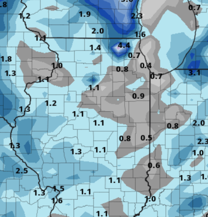
The Canadian has shifted NW. Heaviest snows over Eastern Iowa, NW Illinois, and SW Wisconsin......you know, the places that have gotten all the snow to date. smdh.
-
 1
1
-
-
NAM joins the Canadian with a few inches in N IL Thursday-Friday.
-
 1
1
-
-
lol @ ukie
mchenry county bullseye!
-
So large swaths of Texas and Oklahoma have had more snow this winter than Northern Illinois. Depressing AF. Don't get me wrong, I'm happy for them, but this is unbearable.
-
2
-
-
5 hours ago, RCNYILWX said:
I never like to bust a forecast, but figure if the bust is for less clouds than forecast, that would be appreciated by most given how cloudy it's been lately. You're probably in the minority lol and you get your clouds back today and probably through tomorrow too.
I know Wednesday-Wednesday night looks mild ahead of the front, but I wouldn't lock in temps being able to rise that much yet. That kind of warmth aloft coming in will mean a sharp inversion locks in if there's existing cloud cover (which looks quite possible) and surface advection will be from over areas still with deeper snow cover. Wouldn't be surprised if forecast high temps bust low on Wednesday.
Yes, I'm quite confident most everyone else appreciated the sun! lol
Hope you're right about Wednesday. Concerned everything will get wiped out and then it will be cold and brown. The worst!
-
1
-
-
I was really hoping to retain it prior to the colder pattern, but looks like whatever is left will likely melt almost completely by Thursday. If we don't get any snow with push of cold air after that, it will be worst case scenario - cold and brown. Euro gives some hope of at least a couple inches, we'll see. Still a long ways off. What a ridiculous dry spell, but that's been par for the course here. We've had very long periods of dry weather since June.
-
1
-
-
Todays forecast in NE IL was a huge bust.
-
Well, I was quite surprised and quite unhappy to see the sun out this morning. Temp already shot up to just shy of 36º. Forecast was for 31º and clouds. I need to keep what little snow I have.
-
1
-
-
1 minute ago, Baum said:
I want part l
hard same
-
2
-
-
We just had some clearing and the sun is visible through higher clouds and the temp jumped to 34º. The forecasts this week haven't been good temp wise at all. The clouds are wreaking havoc. Also, I want the clouds, temps are too warm for the sun to come out, too.
-
9 hours ago, kevlon62 said:
This was around dusk today. Streetlight, magic hour and thick fog came together to make it look like a clear day shot.
Sent from my SM-N960U using Tapatalk
Yeah, I realized that a bit later. lol
-
2 hours ago, kevlon62 said:
Top shelf in my winter book all day long.
I'll take a week of this with no complaints.
Sent from my SM-N960U using Tapatalk
Was that today?! I haven't seen the sun and blue skies this year......
-
3 minutes ago, RCNYILWX said:
Spot on, it's unfortunate to have the zzzzs that long but hopefully it ends up being worth the wait. Very good EPS and GEFS agreement in the western ridging retrograding off the west coast beyond January 1/15. The other noteworthy development in the past few full ens runs is amplified poleward ridging with the ridge axis up across the center of AK.
Given the continued Arctic and North Atlantic blocking, that strengthening -EPO signal ups the ante for very cold air to get involved in addition to the RNA (-PNA) due to the retrograding western ridge supporting a more active look. Prior to the -PNA (if the ens are on the right track) we could start to see more clippers materialize and the lake effect belts should take off.
The good news is that the ensembles haven't backed off at all on a more favorable look for the subforum. The bad news is we still have this long boring stretch to get through.
I'd love some clippers.
-
4
-
-
just had a good burst of snow with the trough moving through, got in the "yellow" on the super res radar. came down pretty good for about 5-10 minutes. solid coating.
-
3
-
-
Looks like a squall line coming down from Wisconsin. lol
-
1
-
-
1 minute ago, RCNYILWX said:
Revisiting what I posted earlier today, no changes in overall thinking based off most recent ensemble runs. End of 12z EPS quite promising in showing a slightly -PNA developing as the western NOAM ridge retrogrades off the west coast, which the GEFS continues to point toward as well. We can only hope this look gets to within 10 days because I could see it offering multiple chances to more than localized portions of the sub given the -AO/-NAO favored to lock in.
Prior to that, definitely a stagnant zzzz look. There's a chance some southern stream energy can break through later Sunday into Monday to bring a light snow threat for some areas. Ensembles showing low to medium chances of light measurable QPF during that time and the 12z GGEM did show a weak wave as well. Definitely not seeing anything supporting even widespread advisory type snows while we're in this blocky STJ dominated pattern.
Sent from my SM-G965U using Tapatalk
As long as I can retain much of my snow cover, I'll be okay until it snows again.
-
3
-
Winter 2020/2021 Short Range Discussion
in Lakes/Ohio Valley
Posted
Still doesn't change the fact that it has trended worse for us each run. Monday evening it was looking much nicer. Even yesterday morning. My concerns are the marginal (at best) temperatures and if we don't see steady snow, I could easily see a tenth or two falling and then melting so on and so forth. I have hopes the pattern gets better after this, but I'm not as excited as I had been even last week.
Cary's 15" at ORD call by March 1 is looking good.