

McHenrySnow
-
Posts
537 -
Joined
-
Last visited
Content Type
Profiles
Blogs
Forums
American Weather
Media Demo
Store
Gallery
Posts posted by McHenrySnow
-
-
1 minute ago, tuanis said:
Dryairpalooza. So much for this thing starting with a bang. DSM looks good though. Weird storm, but somehow fitting for this winter.
Yeah, the flurries earlier were a cruel trick.
-
9 minutes ago, A-L-E-K said:
Glad to have McHenrySnow posting fwiw
sarcasm?
-
1 minute ago, RCNYILWX said:
Did you check out your P&C? Our dayshift went big for Cook.
Sent from my SM-G965U using Tapatalk
Your day shift went big for Eastern McHenry and Lake too
-
 1
1
-
-
Just saw a flake.
-
1
-
-
1 minute ago, SchaumburgStormer said:
Flakes flying in Sycamore
Ahead of schedule. Good.
-
Wind definitely starting to pick up. I think I'm in the minority, but I hate blowing and drifting. I like heavy snow in calm wind.
-
1
-
-
Just now, Sciascia said:
It snowed 6 inches in Poplar Grove right after Christmas, and it hasn’t gotten warm enough to melt to unbury the Christmas lawn inflatable that’ll be further buried under the snow & ice tonight.
The candy canes that line our driveway are still mostly buried in the glacier as well.
-
2 minutes ago, tuanis said:
Saturation underway. Wonder if precip breaks out ahead of schedule. LOT is saying 6 PM up here, hi-res models say 7-9 PM. Just picked up a bunch of dog turds half-buried in the glacier that's been around for more than 3 weeks before they get snowed over. Pretty stiff NE wind out there.
Husband did the same yesterday, lol.
-
 1
1
-
-
My P and C forecast appears quite bullish.
-
1 minute ago, CheeselandSkies said:
Rather surprisingly, MKX went with a warning for their far SE or "KRM" counties (Kenosha, Racine, Milwaukee) for potential lake enhancement plus onshore winds (per the AFD).
Models have been increasing totals there for sure. Looks like widespread 6" in those counties possible.
-
 1
1
-
-
The 18z NAM came in...........wetter! across N IL at least.
-
1
-
-
I know where all the moisture is.....
-
2 minutes ago, Cary67 said:
Should have stuck with original 3" magic 8 ball forecast
Remember when I moved to the far NW suburbs to get more snow? hahahahahahahaha
-
18z HRRR a real kick in the teeth for McHenry County. Sadly looking like my 4" call will be right (if not a bit high).
-
2 minutes ago, cyclone77 said:
With Des Moines already at 29" of snow for the season, they're looking to exceed 40" by tomorrow as a foot of snow there is looking like a slam dunk. Amazing winter for them.
And I think they average around 33" or so? They've been blessed, that's for sure.
-
3 minutes ago, ChiTownSnow said:
Agreed.. But it was for different reasoning back then.
No. I said the low was shearing out and less snow as you go east, but the lake would counteract that for lakeshore counties leaving the counties in the middle with lower accums. That's the same reasoning I see NWS mentioning. It's been evident for a while that this would occur. My only hope is that higher ratios further north pan out, but depending on ratios is a fool's errand.
-
 1
1
-
-
23 minutes ago, Baum said:
Tremendous messaging by LOT on this event in my opinion from a public perspective. Never bit on the high end numbers from 2 days ago and have pretty much stayed the course on a solid 6 " event. The latest update on accumulation refinement between I-39 and I-355 is another nice touch given that area will be in between the best accumulation maxima. Sadly, I'm in that zone..
I vaguely recall saying this on Saturday.
-
1
-
-
7 minutes ago, Cary67 said:
Hoping far SE McHenry does a bit better than Harvard. This time RFD doesn't do better
We will see. They usually find a way! lol
-
1 hour ago, Cary67 said:
Final call 5". Snowfall this winter is a grind to come by
bullish
-
2
-
-
Quite the difference between 12k and 3k NAM.
-
Well, the 0z NAM seems to have stopped the bleeding. Overall, certainly not drier.
-
1
-
-
2 minutes ago, purduewx80 said:
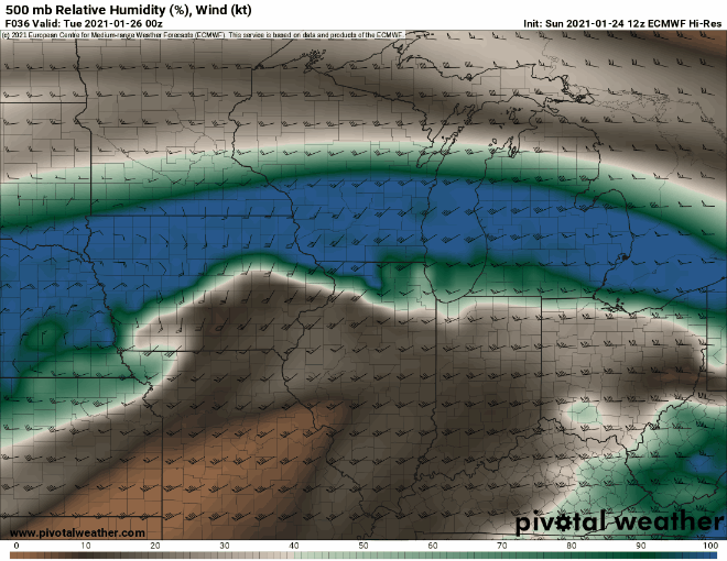
Going to have to watch this dry slot at 500mb closely tomorrow evening. A lot of today's guidance is showing a drying out of the dendritic growth zone and is no longer co-locating the best lift within that layer. Both of those things are negatives when it comes to snow-liquid ratios. The DGZ is just below 500mb but these RH plots are a good proxy for where there is better saturation, based on all the forecast soundings I've seen. GFS is on its own for the Chicago area. If the other guidance is right, precip will be showery by the time it reaches Chicago and could produce grainier snow w/ ratios as low as 5-6:1.
Relying on good ratios is similar to relying on lake effect in that more often than not you're going to be disappointed.
-
1
-
-
Just now, metallica470 said:
LOT better be praying for some nice lake enhancement to reach those totals lol
Those counties aren't going to get lake enhancement.
-
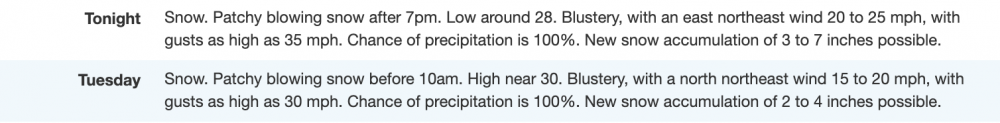
Winter Storm Warning
URGENT - WINTER WEATHER MESSAGE
National Weather Service Chicago IL
255 PM CST Sun Jan 24 2021

...Winter Storm to Impact the Region Beginning Monday
Afternoon...

ILZ003>005-250500-
/O.UPG.KLOT.WS.A.0001.210125T2200Z-210126T1800Z/
/O.NEW.KLOT.WS.W.0001.210125T2200Z-210126T1800Z/
Winnebago-Boone-McHenry-
Including the cities of Rockford, Belvidere, Crystal Lake,
Algonquin, McHenry, and Woodstock
255 PM CST Sun Jan 24 2021

...WINTER STORM WARNING IN EFFECT FROM 4 PM MONDAY TO NOON CST
TUESDAY...

* WHAT...Snow, heavy at times, especially Monday evening and
  overnight. Total snow accumulations of 5 to 7 inches. Northeast
  winds gusting as high as 35 mph resulting in periods of very
  low visibility.

* WHERE...Winnebago, Boone and McHenry Counties.

* WHEN...From late Monday afternoon through Tuesday morning.

* IMPACTS...Travel could be very difficult. Hazardous conditions
  are likely to impact the Monday evening and Tuesday morning
  commutes.

* ADDITIONAL DETAILS...Some power outages are possible due to
  the combined effects of the expected wetter nature of the snow
  and strong and gusty winds.

PRECAUTIONARY/PREPAREDNESS ACTIONS...

If you must travel, keep an extra flashlight, food, and water in
your vehicle in case of an emergency.

The latest road conditions for Illinois can be obtained on the
internet at www.gettingaroundillinois.com.

Jan 25-26th Potential Something Part 3
in Lakes/Ohio Valley
Posted
Yep, probably until morning per Twitter. Never fails.