

stormdragonwx
-
Posts
512 -
Joined
-
Last visited
Content Type
Profiles
Blogs
Forums
American Weather
Media Demo
Store
Gallery
Everything posted by stormdragonwx
-

Severe Weather 4-30-24 through 5-2-24
stormdragonwx replied to cstrunk's topic in Central/Western States
I believe we are witnessing a rare tornado family? -
Severe Weather 4-30-24 through 5-2-24
stormdragonwx replied to cstrunk's topic in Central/Western States
Another one just formed directly to the east of the anti-cyclonic one. Grandfield, OK might be in trouble here. -
Severe Weather 4-30-24 through 5-2-24
stormdragonwx replied to cstrunk's topic in Central/Western States
And there's the CC drop. -
Severe Weather 4-30-24 through 5-2-24
stormdragonwx replied to cstrunk's topic in Central/Western States
Yes insane couplet showing up on FDR -
Severe Weather 4-30-24 through 5-2-24
stormdragonwx replied to cstrunk's topic in Central/Western States
SW OK storms continue to consolidate and ramp up. Betting we will see a nasty tornado out of this one soon. -
Severe Weather 4-30-24 through 5-2-24
stormdragonwx replied to cstrunk's topic in Central/Western States
My thoughts too... what a crazy couple weeks this has become. -
Severe Weather 4-30-24 through 5-2-24
stormdragonwx replied to cstrunk's topic in Central/Western States
So are we gonna talk about those storms in SW OK? They already had at least 1 confirmed tornado. -
Severe Weather 4-25 through 4-28-24
stormdragonwx replied to cheese007's topic in Central/Western States
Night Of The Twisters: Oklahoma Edition -
MO/KS/AR/OK 2023-2024 Winter Discussion
stormdragonwx replied to JoMo's topic in Central/Western States
Unless something really drastic comes up on the data I'm thinking R.I.P. winter. -
MO/KS/AR/OK 2023-2024 Winter Discussion
stormdragonwx replied to JoMo's topic in Central/Western States
Looking at some of the long term data we might be done unless something happens in March. Showed promise but turned out to be a very meh season. -
MO/KS/AR/OK 2023-2024 Winter Discussion
stormdragonwx replied to JoMo's topic in Central/Western States
Had snow for about an hour here in Fayetteville and now we're getting dry slotted hard in the NWA area, might be a bust here. Never fails. -
MO/KS/AR/OK 2023-2024 Winter Discussion
stormdragonwx replied to JoMo's topic in Central/Western States
Data still looking insane for many areas along I-44, still waiting on a few more 00z models to come in. -
MO/KS/AR/OK 2023-2024 Winter Discussion
stormdragonwx replied to JoMo's topic in Central/Western States
12z runs, take it as you will HRRR 3km NAM WRF-ARW NSSL-WRF FV3 Basically areas to note is Central/SW OK and extreme NW AR and SW MO get slammed tonight. Even accounting for melting this could be significant. -
MO/KS/AR/OK 2023-2024 Winter Discussion
stormdragonwx replied to JoMo's topic in Central/Western States
00z runs (divide totals by 2 to account for melting that will likely occur) HRRR NSSL-WRF FV3 3km NAM RRFS-A -
MO/KS/AR/OK 2023-2024 Winter Discussion
stormdragonwx replied to JoMo's topic in Central/Western States
Yeah looks to be returning to our Nov-Dec pattern. Wonder what the rest of Feb into March shows or if that was our winter for the season. -
MO/KS/AR/OK 2023-2024 Winter Discussion
stormdragonwx replied to JoMo's topic in Central/Western States
Yeah Dan Skoff in his FB Live Update towards the end of the video sounded quite worried about how this could potentially overperform. The AR River Valley along I-40 could really get it. https://www.facebook.com/NWAWeatherAuthority/videos/930132298622291 -
MO/KS/AR/OK 2023-2024 Winter Discussion
stormdragonwx replied to JoMo's topic in Central/Western States
I will say I am not too thrilled about the icing potential next week. At least in snow you can get around if you know what you are doing. It also means more power disruptions which is not ideal with the extreme cold we have had. -
MO/KS/AR/OK 2023-2024 Winter Discussion
stormdragonwx replied to JoMo's topic in Central/Western States
Could be my imagination but it might be back building a bit towards Tulsa on the latest radar scans? -
MO/KS/AR/OK 2023-2024 Winter Discussion
stormdragonwx replied to JoMo's topic in Central/Western States
Currently 1 degree with moderate to heavy snow falling. About 2" so far. -
MO/KS/AR/OK 2023-2024 Winter Discussion
stormdragonwx replied to JoMo's topic in Central/Western States
Yeah and people were panic buying at the stores over the past couple days too once the Watch/Warning got posted. A lot of people are gonna be PO'd. We will probably just see a repeat performance of Friday with flurries and a dusting at best. I mean this isn't even warning criteria. Really confused on why they went with the Warning.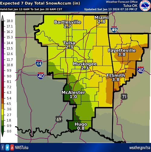
-
MO/KS/AR/OK 2023-2024 Winter Discussion
stormdragonwx replied to JoMo's topic in Central/Western States
Yeah 00z models appear to be coming in even drier. I am thinking this is gonna bust and they will downgrade the warnings to an advisory. -
MO/KS/AR/OK 2023-2024 Winter Discussion
stormdragonwx replied to JoMo's topic in Central/Western States
Personally I'm really surprised they went for a Warning. 2-4" is barely even Warning criteria. (4+ is) Another thing too is the air is extremely dry at the midlevels which will cause sublimation to occur. -
MO/KS/AR/OK 2023-2024 Winter Discussion
stormdragonwx replied to JoMo's topic in Central/Western States
With the models trending drier I am expecting TSA and the others will drop the watch and replace it with another advisory. -
MO/KS/AR/OK 2023-2024 Winter Discussion
stormdragonwx replied to JoMo's topic in Central/Western States
Watch it winds up being right. -
MO/KS/AR/OK 2023-2024 Winter Discussion
stormdragonwx replied to JoMo's topic in Central/Western States
Yeah GFS took a dump too. Not as dramatically as the Euro, but noticeable. 4-6" looks to be the high end versus the widespread 6-12" we were looking at a couple days ago. Only one still going crazy is the Canadian but its focusing a swath of 15-20 inches (Kuchera) way down in Central/Southern AR now. Looks like the moisture is being choked off & shunted to the SE. And naturally I got new tires and wiper blades. lol
