stormdragonwx
-
Posts
512 -
Joined
-
Last visited
Content Type
Profiles
Blogs
Forums
American Weather
Media Demo
Store
Gallery
Everything posted by stormdragonwx
-

Severe Weather April 6th-10th 2021
stormdragonwx replied to cheese007's topic in Central/Western States
Yeah scratching my head on this one. Maybe we will have more clarity later today. https://www.spc.noaa.gov/products/outlook/day2otlk.html -
Severe Weather April 6th-10th 2021
stormdragonwx replied to cheese007's topic in Central/Western States
Maybe its just me but the SPC seems to agree with what I suspect that the threat looks to be trending in the wrong direction now for being another worthwhile chase opportunity. But we still got 36-48 hours to go so we will see. https://www.spc.noaa.gov/products/outlook/ -
OK/AR/KS/MO Spring 2021 Discussion
stormdragonwx replied to OKTWISTER's topic in Central/Western States
Kinda thinking we might get something towards the end of April into May (logically and climatology speaking) but overall this may be a Dixie Alley year. -
I know spotter icons are not necessarily accurate to the timing but I will note this doesn't look very good either. I hope we don't get news in a couple days of more chasers being killed by a tornado.

-
I hear ya man. I was right up the road from you. Watched that one promising storm fall apart over Florence. Looks like we are done around here as the other rain showers further south and west look to be struggling. Central AL and east was the place to be again today.
-
Welp time to break out this old gem. https://youtu.be/Keu8J9WgvzQ
-
March 17-18 Severe Weather Event
stormdragonwx replied to DanLarsen34's topic in Southeastern States
2nd PDS Watch issued for the Ark-La-Ms area. -
March 17-18 Severe Weather Event
stormdragonwx replied to DanLarsen34's topic in Southeastern States
^And the clearing allowing substantial surface destabilization. I think 3500-4000 CAPE is not out of the question now for these areas. -
March 17-18 Severe Weather Event
stormdragonwx replied to DanLarsen34's topic in Southeastern States
Yeah that clearing is definitely not something you wanna see on a day like today. -
March 17-18 Severe Weather Event
stormdragonwx replied to DanLarsen34's topic in Southeastern States
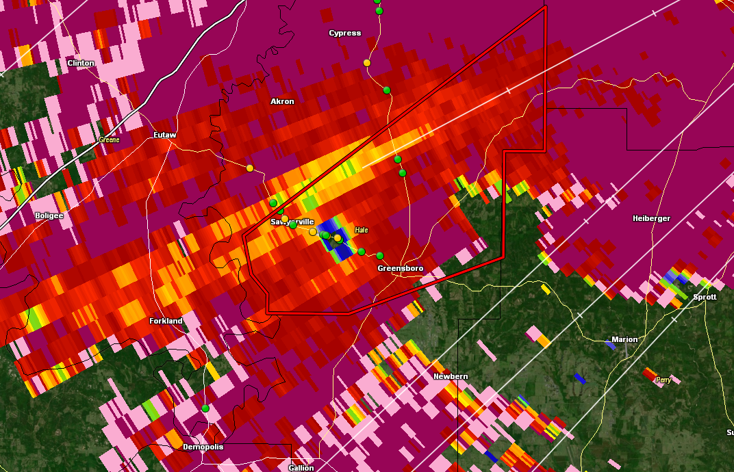
Crazy the High Risk actually happened. And right over Jackson, MS which is my primary chase target. -
March 17-18 Severe Weather Event
stormdragonwx replied to DanLarsen34's topic in Southeastern States
Indeed. *Joplin, Mo has entered the chat* -
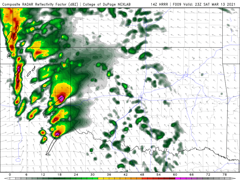
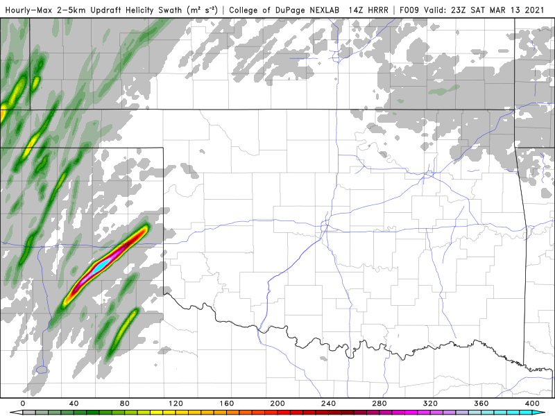
I have to say HRRR did a fantastic job with Saturday. From its guidance going all the way back to the day before, I had targeted an area between Clarendon and Groom, TX. And of course the towns are indeed mentioned in the storm report. The tornadoes even appeared to have crossed at areas where I had actually parked that day. (most notably Washburn, the west side of Clarendon, and Greenbelt Reservoir)
-
1377 tornadoes EDIT: I'm joining the March 17th club too after seeing the latest data. 2nd High Risk day will be April 26th.
-
Clarendon now under the gun. Two storms approaching with couplets..
-
Theres also a lot of haze and cloud cover that hasn't cleared off as expected. I find that concerning. Reminds me of May 20th, 2019.
-
That southern cell will need to be watched too. I'm currently sitting in Clarendon, TX watching it as it marches up to the NE. Tulia and Silverton will have to watch this one. EDIT: Just went Tor Warned as I posted this.
-
Is it a bad assessment to say this looks like 3/18/12 on steroids? This is crazy for March. Feels more like a day in May.
-
I kinda see this being another 3/18/12 day possibly. Saw beautiful storms and several tornadoes on that chase day. Almost in the same area too.
-
OK/AR/KS/MO Spring 2021 Discussion
stormdragonwx replied to OKTWISTER's topic in Central/Western States
An early season event that comes to mind with March is the infamous March 12th, 2006 tornado outbreak. That was a La Nina Spring as well. -
MO/KS/AR/OK 2020-2021 "Winter" Discussion
stormdragonwx replied to JoMo's topic in Central/Western States
With the current pattern I got a hunch it may be on par with 2013. -
MO/KS/AR/OK 2020-2021 "Winter" Discussion
stormdragonwx replied to JoMo's topic in Central/Western States
Looks like I got a total of 8" inches between the two systems here in east Fayetteville. The most since the 2013-2014 winter season. -
MO/KS/AR/OK 2020-2021 "Winter" Discussion
stormdragonwx replied to JoMo's topic in Central/Western States
I'll be curious to see if this one overperforms though TSA keeps reducing totals over here. -
MO/KS/AR/OK 2020-2021 "Winter" Discussion
stormdragonwx replied to JoMo's topic in Central/Western States
Here comes round #2...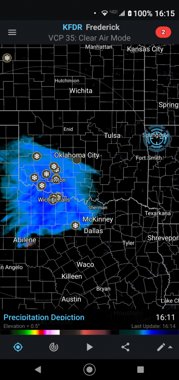
-
MO/KS/AR/OK 2020-2021 "Winter" Discussion
stormdragonwx replied to JoMo's topic in Central/Western States
The moon and stars are out yet we still got flurries. Strangest thing I've seen. -
MO/KS/AR/OK 2020-2021 "Winter" Discussion
stormdragonwx replied to JoMo's topic in Central/Western States
Yeah its still snowing here in Fayetteville. Probably got at least 6" inches now since my measurement last night which had us at 4" inches.