

Modfan2
-
Posts
2,327 -
Joined
-
Last visited
Content Type
Profiles
Blogs
Forums
American Weather
Media Demo
Store
Gallery
Posts posted by Modfan2
-
-
10 minutes ago, Damage In Tolland said:
Over / under 57mph gusts in CT?
Are you counting Fishers Island CT?
-
 1
1
-
-
1 minute ago, weatherwiz said:
Looks like the HRRR keeps the strongest portion of the forced line farther south. That will be a nowcasting event but I think it at least crosses somewhere in SNE. I'm expecting we'll see some severe thunderstorm warnings late overnight and a swath of wind gusts 60-70 mph. Outages are going to lite up like crazy.
Further south like south of LI?
-
39F here in the E CT low lands, melting prior to precip arriving
-
14 minutes ago, jbenedet said:
Denial ain’t a river in Egypt.
It’s gone. It’s gonna be okay.
I have 4” on the ground, I’m not worried about retaining any of it, my question was will the dynamics be different with this storm considering the cold in place down vs the previous cutters in December.
-
Pretty cold here to start, down to 15F; will CAD play a role in the dynamics of this system even down here?
-
7 minutes ago, Damage In Tolland said:
Eversource better have out of state crews heading to New England for what’s coming
https://x.com/eversourcect/status/1744426629798019224?s=46&t=dhcbvkjmRcyBVQtDxJ3lRg
Per Ryan and Scooter doesn’t appear to be a big wind event
-
 2
2
-
 1
1
-
-
11 minutes ago, CT Rain said:
I don't see much of a damaging wind threat. Soundings look far more inverted than the last couple events.
How do rainfall amounts look?
-
3 minutes ago, wx2fish said:
12z stuff definitely likes CT for the higher rain totals
I believe Tip mentioned earlier if the higher totals can be achieved do to the progressive nature of the system
-
12 minutes ago, weatherwiz said:
I'm kind of surprised (though I guess I shouldn't be) this thread isn't getting more attention. Perhaps it's because we're right on the heels of this past weekend's event and everyone is exhausted, but this is going to be a very high impact storm. The flooding, particularly river and stream flooding is going to be very bad. Looking at a widespread 2-4'' of rain and I'm sure we'll see a strip of 5-7'' totals.
Can you post what you are seeing for rain?
-
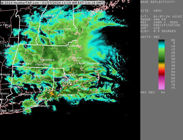
Looks like most of the heaviest rain and wind are in Western sections of CT/Wmass into NY
-
1
-
-
@The 4 Seasonsfinished with 4.5” here in Brooklyn CT
-
2
-
-
Tacked on an additional 1” since overnight up to 3.5”
-
7 minutes ago, ORH_wxman said:
Might be pretty good for eastern areas that got a bit skunked last night..esp those areas like 5-10 miles west of water. With CF crashing across 128 now this CCB stuff can accumulate fairly efficiently.
Finally in a decent band here and starting to accumulate again, see if we can get another 1”
-
Moderate snow now temp down to 32F and starting to stick again
-
@The 4 Seasons 2.5” in Brooklyn CT
-
Looks like best stuff is forming to my east in RI/SE Mass; temp dropped to 33F but precip has lightened and right back to 34F.
-
Temp starting to drop now at 33F and flipped from drizzle back to snow. Cleaned snow and now wet, but not sure if that’s good or bad with dropping temps?
-
Who is tracking amounts that we need to @?
-
How much rain are we looking at Wednesday?
-
2.5 inches of Cement in Brooklyn and 34F yuk!
-
5 minutes ago, Damage In Tolland said:
Cold and powder as far as eye sees

Down this way slightly warmer
-
Moderate here in E CT and 32F with a coating so far
-
Moderate now down to 32 with a coating
-
33 and light snow in Brooklyn CT
1/9-1/10 Now Morphing to Less-Than-Exciting Power Cutter
in New England
Posted
37F and .51 of rain so far, melting commencing