Dalfy
-
Posts
514 -
Joined
-
Last visited
Content Type
Profiles
Blogs
Forums
American Weather
Media Demo
Store
Gallery
Everything posted by Dalfy
-
My initial report was off - we were mostly sleet until maybe 50 minutes ago when we switched to all snow. Currently a little more than a dusting over a thin layer of sleet. RAP has another 9-10 hours of this, which is nice -- I think we will end up with the 1-3'' NWS is forecasting. Too bad it will all melt tomorrow lol.
-
All snow in lebanon, currently dusting on my car.
-
NAM looks alot better than 12z for central NH.
-
We have ~4'' in lebanon. I'm impressed by the remarkably good snow quality.
-
Looks like I finished with a little over 8'' in lebanon.
-
The wet snow on the conifers looks so amazing. We're getting pure dendrites and dendrite aggregates now which is adding a beautiful sparkle to the snow pack. I measured 6-7'' on top of what was left from our major storm a few weeks back. Looking like a winter wonderland with even more to come!
-
Almost whiteout in lebanon, impressive rates!
-
It's been coming down pretty good for the last hour or so, after the column finally saturated. Temp is 30F
-
Feb 10-11 Mid Week Minor Event - Ride the hot hand?
Dalfy replied to HoarfrostHubb's topic in New England
We've had light snow showers throughout the day with some more heavier bands over the last hour or two in Leb. Nice large flake clumps coming down. Minimal accumulation since last night that I can eyeball. -
Feb 10-11 Mid Week Minor Event - Ride the hot hand?
Dalfy replied to HoarfrostHubb's topic in New England
Snow lightening up a bit after a briefly heavy band passed over. I want to say something like 3-4'' on the ground as things wind down now. -
Feb 10-11 Mid Week Minor Event - Ride the hot hand?
Dalfy replied to HoarfrostHubb's topic in New England
~2'' on the ground in Lebanon. Radar currently shows nothing overhead but we are getting light snow, intensity is less than an hour ago. -
Feb 10-11 Mid Week Minor Event - Ride the hot hand?
Dalfy replied to HoarfrostHubb's topic in New England
Seems like we're battling quite a bit of virga in Leb, humidity is at 50%. Flurries to very light snow despite ~25 dbz. -
Feb 10-11 Mid Week Minor Event - Ride the hot hand?
Dalfy replied to HoarfrostHubb's topic in New England
Seeming like 3-6'' in Leb too. -
16.8'' for an 830pm report out of west hartford vt, 20 minutes from me. I think I'm a little under that, estimating roughly 15'' or so.
-
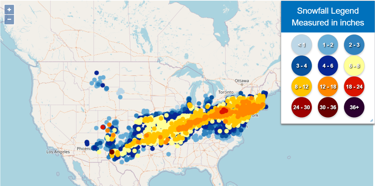
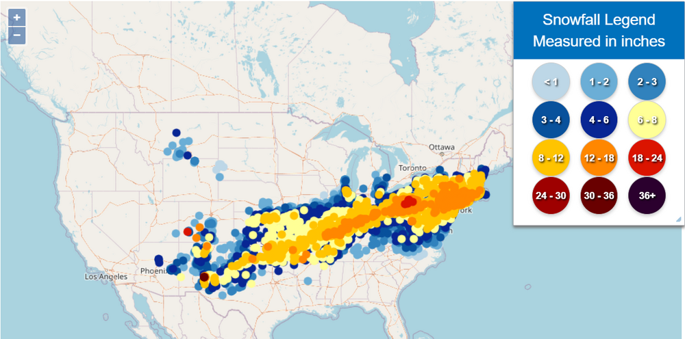
If they factor in non Northeastern states it may border 5. Estimated damages were in the 100 billion range, over 1 million without power.
-
Wow, massive hit
-
Light snow still ongoing. Haven't checked how much has fallen since 2pm but I anticipate a few inches as my car is covered yet again :/. I imagine we are somewhere near the 14'' mark.
-
Big aggregated dendrites, moderate snow in lebanon. As usual, the radar is not picking this up lol.
-
Moderate to heavy snow, large dendrites in Lebanon.
-
Light to moderate snow Lebanon, ~8-9'' on the ground in 3 places. Looks like near a 10:1 ratio assuming we got modeled level of precipitation - 0.8-0.9. I imagine possibly another inch or two over the course of the day to bring our total close to 10''.
-
Snow intensified quite a bit since I last checked.
-
Measured ~6-6.5'' in 2 places, there may be some compaction but overall this is less than I imagined it would be. Still snowing at a moderate pace, 4F.
-
Such an impressive swath of impact.
-
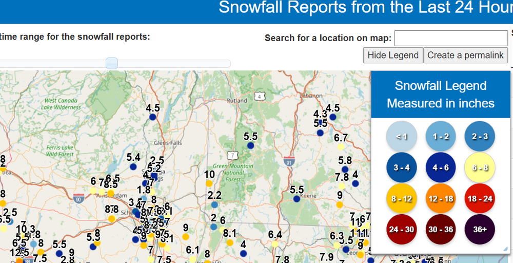
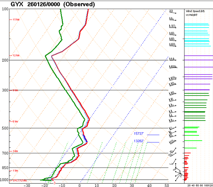
I was wondering if someone with more knowledge could help me understand the soundings and non-optimal snow growth we're seeing. Looking at the observed 0z Monday sounding for GYX that just came out, it looks like the most saturated parts of the column are in the DGZ, but the saturation is incomplete. I'm wondering we have the right temps here but the reason we're seeing finer powder / plates instead of large dendrites is the lack of saturation. Am I understanding this correctly?

-
There's a snow spotter report of ~5.5'' from 430pm. Looks like they're doing fine.