

Dalfy
-
Posts
514 -
Joined
-
Last visited
Content Type
Profiles
Blogs
Forums
American Weather
Media Demo
Store
Gallery
Everything posted by Dalfy
-
Precip is on our doorstep, I'm hoping we squeeze out an inch or two before the sleet changeover.
-
Really great summary of the two waves for those in the LSX forecast area. As was previously discussed, two relatively distinct rounds of wintry precipitation will impact the region. The first round, forced mainly be isentropic overrunning stimulated by a shortwave amidst southwesterly mid-level flow, will draw wintry precipitation into the region. Latest short-range ensembles and CAMs now indicate a weaker, more confined area (largely along/south of I-70) of wintry precipitation with this first round. From a conceptual standpoint, this makes sense as the upper-level synoptic forcing and isentropic ascent is not impressive by any stretch. Model soundings Wednesday evening illustrate a sub-saturated DGZ, with a deep saturated layer beneath that amidst modest lift. A stout warm nose that barely peaks above freezing aloft can be discerned between I-70 and I-44, but any hydrometeors that melt will most likely refreeze as sleet in the deep cold layer beneath. Further south still, we will likely see more mixing of rain and sleet where the warm layer is deeper. While accumulations with this initial round will be lighter compared to the next bout on Thursday (as the forcing within the system is so weak), the onset timing coinciding with the evening rush hour will likely lead to travel impacts. Overnight Wednesday into early Thursday morning, what weak overrunning and forcing that does exist will further diminish and precipitation will become lighter and more scattered across the southern CWA. Some model soundings hint at the potential for freezing drizzle during this "lull" overnight. A nearly-saturated layer extending from near the surface to around 700mb exists overnight south of I-70 with some modest lift in the layer. While light, a glaze of ice cannot be ruled out for some during this relative break in the system. The more impressive of the two waves will move into the bi-state area during the early morning on Thursday and will re-stimulate precipitation areawide in time for the morning commute. Deterministic guidance agrees that the orientation and depth of the mid-level trough will not be favorable for more robust surface cyclogenesis. While a low will be deepening, it will be slow to do so given the weak amplification and diffluence in the mid/upper levels. As such, moist isentropic ascent and overrunning would be the main sources of forcing for this second round. This scenario is supported in the isentropic fields among the deterministic guidance, which shows more extensive and impressive isentropic lift across the region. Precipitation types will vary across the region tomorrow. North of I- 70 will see almost exclusively snow, but given the lack of a more robust synoptic system any mesoscale banding that would cause more intense localized snow totals are highly unlikely. Another aspect working against higher snow totals: the DGZ never saturates in any notable way, which severely decreases the efficiency of dendritic growth. This scenario is further supported by the NBM interquartile range for snow not including amounts larger than 4" in the northern CWA. There is some raw guidance that suggests higher amounts, but they are likely being influenced by sleet contamination. For the area that will largely see accumulating snow and not much changing precipitation type, a Winter Weather Advisory was issued this afternoon. South of this area, along I-70 south to just south of I-44, a corridor of significant sleet is expected to develop and cause notable impacts to travel for the morning commute Thursday. Model soundings show more notable lift compared to the first wave, with a largely-similar thermodynamic profile. NBM probabilities of sleet are also relatively high in the mid/late morning through the afternoon (topping out at 60%, but may still be too low). Sleet accumulations up to 1" can be expected, which would be quite impactful. As such, a Winter Storm Warning was issued for the areas where sleet accumulations would exceed 0.5". Further south still, the depth of the warm nose aloft will be much more pronounced, which in turn makes the cold air below it more shallow. This would be a much more favorable scenario for freezing rain, especially if surfaces cool as precipitation falls with the first wave of wintry mix Wednesday evening. That being said, accumulations on roadways will still be limited as the sun angle for this time of year and barely-freezing conditions will not promote efficient accretion. Admittedly, this forecast may be a bit too bullish on those ice totals, especially if the above-mentioned limitations come to fruition. On elevated surfaces, which would be a bit cooler, ice accretion would be more efficient and could lead to downed tree limbs and power outages in southeast Missouri and southwest Illinois. Given the potential for significant impacts and ice accumulations, a Winter Storm Warning more specifically for ice was issued across southeast Missouri and southwest Illinois. Precipitation wanes during the evening Thursday from west to east as the system intensifies and ejects east out of the region. Temperatures stay below average and skies begin to clear as our third winter system in as many weeks comes to an end.
-
GFS trended toward Euro and is warmer for STL. It's looking like we'll mostly be sleet for this storm.
-
Pouring buckets of snow in this final band, wow. Extremely windy as well.
-
STL changed over to mostly sleet around noon. We have a light layer, maybe 0.5'' of sleet, ice and snow on the ground. Temp is 28
-
Last week of February looks really interesting on Euro and GFS and has been so for the past few days.
-
Beautiful outside. Snow is very powdery and blowing everywhere. Rates are not as high as I'd hoped, I may have slept through the best of it, but it's still great to watch. This was a very spread the wealth storm, which I've also appreciated quite a bit.
-
~7'' so far IMBY. Snow rates still 20-30dbz. Powdery snow. Looks like another few hours left.
-
I've been in 20-25dbz returns for the last hour or so, I'll take a short walk to get sense of depth. Visibility slightly under a mile I want to say. Temp is 17.
-
First flakes just starting to fall in the STL metro area. It's incredible to see the precip shield of the two waves on one map, there's rain and snow falling from the US-mex border all the way to maine.
-
Radar looks so juicy
-
Second wave at LSX's doorstep, hoping for 4-8''to pad the 2'' from this morning.
-
We're officially all snow, at 12z, ~4-8 hours earlier than short term guidance forecasted [RGEM, RAP, HRRR] up until 1 or 2 last night. I'm really looking forward to the afd as they also went with short term in suggesting changeover would occur sometime in mid morning through early afternoon.
-
Here's a webcam from near forest park in St. Louis for those interested: https://fox2now.com/webcams/chess-club-hall-of-fame-in-the-central-west-end/
-
Wow, I looked outside and it's currently sleet/snow with trace accumulation on grass. Temp is 31.
-
30 with snow/rain mix in STL
-
Don't take my word for it but I think it'll be in the next 2-3 hours max. Current wetbulb temps; check the time trend on spc:
-
Maples' rough estimate of changeover- Jefferson, MO and metro. 1-4am sounds right and earlier than Canadian guidance by 10-12 critical hours. I don't think I'll be able to sleep monitoring this haha: .AVIATION... (For the 06z TAFs through 06z Wednesday Night) Issued at 1040 PM CST Tue Feb 1 2022 A high impact winter storm is imminent with a broad area of precipitation stretching from central Illinois southwestward through a large portion Missouri. Rain transitioned to all snow at KUIN around 02z this evening with the transition affecting KCOU between 03z and 04z. Following shortly behind will be KJEF around the release of this update. Metro terminals will likely follow between 07z and 10z.
-
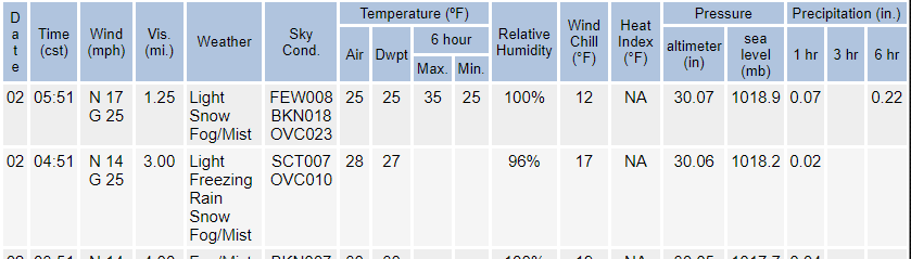
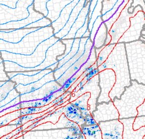
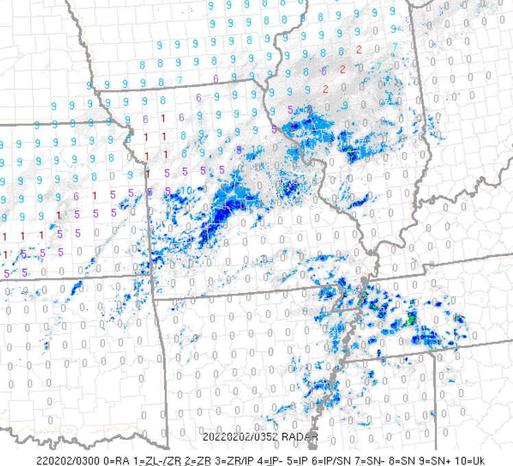
For those in LSX: 000 FXUS63 KLSX 020254 AFDLSX Area Forecast Discussion...Updated National Weather Service Saint Louis MO 854 PM CST Tue Feb 1 2022 .UPDATE... Issued at 830 PM CST Tue Feb 1 2022 A broad area of precipitation stretches from interior sections of central Illinois to southwest Missouri this evening. Coverage and arrival time of the precipitation is in good agreement with expectations so far. Automated surface observations show sub-freezing air making progress into portions of northeast Missouri and west-central Illinois. Rain transitioned to a brief period of freezing rain/sleet around Quincy before changing to all snow around the 02z hour. Reports of all snow in Hannibal also provide ground truth to the advancing cold air. What has been evident over the last 3-4 hours is that the cold air has run about 20-25 miles further southeast than hourly forecast trends previously depicted. Updates have been made to reflect this trend with the potential that FZRA/PL could be 1-2 hours ahead of schedule, should this trend win out. The only question remains the warm nose aloft and how long it holds/erodes tonight into the morning period. This trend will need to be monitored through the night, as any deviation will have the greatest impact on accumulations near the transition zone (southeast MO/southwest IL). Maples && Current rain snow line:
-
16'' downtown STL lol, crazy.
-
It seems MBY continues to be at a real battleground with respect to warm layer. 18z RGEM and 12z GGEM maintain warm layer aloft well into Thursday which keeps us mixed for most of the event; NAM, EURO, GFS have trended toward warm layer cooling by late Wednesday night/00z Thursday which keeps us snow for precip thrust from the main low which is resulting in these boosted forecast totals. I'm liking my chances especially given the new 00z guidance, we'll see how RGEM and GGEM trend tonight. EDIT: RGEM came in slightly cooler, with changeover around 6z Thursday.
-
ILX is going to get shellacked. It seems like track is relatively consistent, I'm just hoping the warm nose erodes fast enough for us in St. Louis.
-
This includes sleet correct? Going by sim radar St. Louis doesn't changeover to snow until ~hr 87. QPF after is ~.4. 9.7'' seems high.
-
<6'' STL for both events. I'm hoping GHDIII puts an end to the northern monopoly. STL-DTW axis lets go #1982
-
It's a small user base but we do post here.
