

Rhino16
-
Posts
1,419 -
Joined
-
Last visited
Content Type
Profiles
Blogs
Forums
American Weather
Media Demo
Store
Gallery
Posts posted by Rhino16
-
-
12/06/23 - T
12/11/23 - 0.2” -
Looks like you all got more than us, which looks like what was modeled closer to the event, guess we’ll see later.
-
 1
1
-
-
8 minutes ago, TSSN+ said:
Dude I’m in Westminster and is raining here again with a little snow mixed in while area just north are snowing.
Short Pump snow hole doing work then… that sucks. At least I don’t need to change majors.
-
If short pump gets more snow than blacksburg, I’m changing majors to something other than meteorology.
-
 1
1
-
-
35 minutes ago, RIC Airport said:
Fingers crossed for recording a trace!!! Too bad temps won't drop below the mid 30s.

I bet you see more than we did out here. If so, I quit meteorology and will be changing majors.
-
1
-
-
I don’t know what’s happening, but it’s still going here despite clear radar…
-
Snow is about to end in Blacksburg with a trace, best of luck to y’all at home. Thanks for the rainfall updates.
-
1
-
-
Finally snowing here! Large flakes maybe some rain still… but almost done switching.
-
7
-
-
Rain with icy stuff is occurring.
-
5
-
-
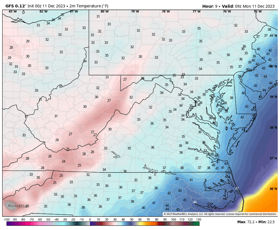
42.8 already in Blacksburg. Dropping surprisingly quick.
-
11 minutes ago, CAPE said:
The NE PAC trough is too dominant right now. That feature is a fixture in a Nino but we don't want it to be a monster vortex parked in the GoA. Right now there is TPV energy feeding into it, but all the extended products still indicate some weakening and retrograding towards the Aleutians into early Jan, with improvement in the PNA/EPO domains. Some improvement in the NA would also be really helpful. We watch and wait.

It’s smiling at me. It has that look that means we’re in for snow!
edit: same thoughts as above
-
So far, I think my rainfall for tomorrow was too much, and we’ll get most of that today, if any. Heavy stuff approaching. At 0.56” for the day at airport.
-
NAM has 0” for me now, still happy to see a few flakes hopefully.
-
It thundered this morning as it moved through.
-
15 minutes ago, RIC Airport said:
That seems about right, @Rhino16. It will be interesting to see how late the bulk of the precip reaches I-95 in the Richmond area tomorrow. That will potentially determine whether you are a bit too high for the 10th.
I think I will go with a trace of snow at RIC for the 11th, the first of the season which gets RIC on par with stations like DCA and IAD.
Yeah that will be interesting. I didn’t mind the snow for richmond due to the small amounts. Here in Blacksburg though, I’m a bit more excited.
-
1
-
-
My RIC Predictions:
10th:
Hi/Lo: 66/45
Precip: 1.91"
11th:
Hi/Lo: 51/30
Precip: 0.71"
-
1 hour ago, RIC Airport said:
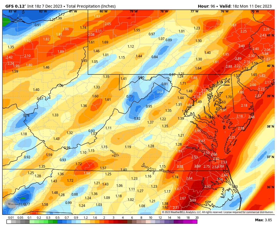
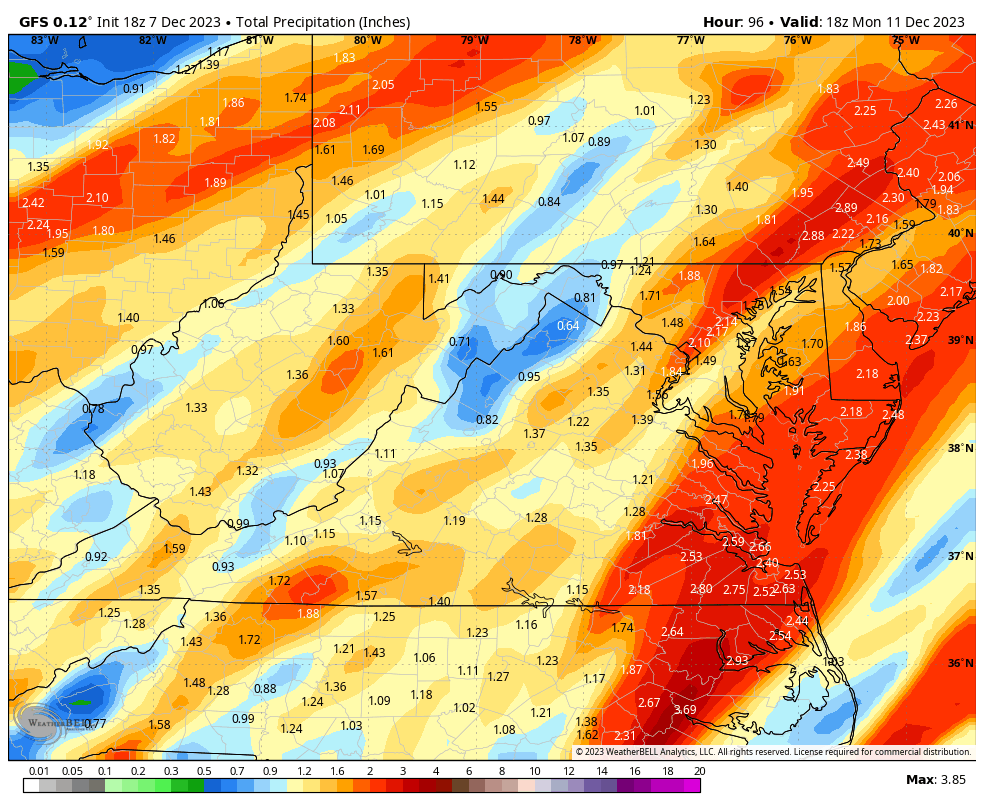
Sunday's front is looking similar to the one just before Thanksgiving with widespread 1-3" of rain across the region. The window for rain looks to start around 10am in the Richmond metro area and 3-4pm in Hampton Roads.
The heaviest rain will arrive later in the evening after sunset, as indicated by today's 18Z GFS below. It's good to see we are finally getting Nino-induced moisture. We must get colder in our region and line it up with moisture. It's only December, and hopefully, we see signs of opportunity soon.
")
Hope to see flakes on the end of that here in blacksburg, will attempt another forecast for RIC on Saturday.
-
1
-
-
Just from some forecasting I’ve done over the past few weeks, the GFS has done very well on precipitation. I’m terrible at temperatures though, but that’s because of the situations we’ve been given each week. Also agree the Euro has been not as great. Sometimes however, it will be 5° warmer than anything else and somehow be the closest. I’m trying to get some practice in to see when and when not to trust it.
-
1
-
-
17 hours ago, PrinceFrederickWx said:
Thank you for calling the AmWx Panic Room Hotline- the #1 source of trusted weather analysis on the web. If this is a life-threatening emergency, please hang up and dial 911 now. Due to a high volume of calls, your wait times may be longer than usual.
Please listen carefully as our menu options have recently changed:
-For trouble with your long range model performance, please press “1”
-For trouble with your El Nino performance, please press “2”
-For trouble with your backyard’s seasonal snow total performance, please press “3”
-For trouble with a December Pac Puke pattern, please press “4”
-For all other inquiries, or if your name is Ji, please stay on the line, and a customer account executive will be there to assist you shortly.
Which option should I dial to panic over southeast ridge troubles?
-
There’s also like 30-40mph gusts so walking to class will be great.
-
1
-
-
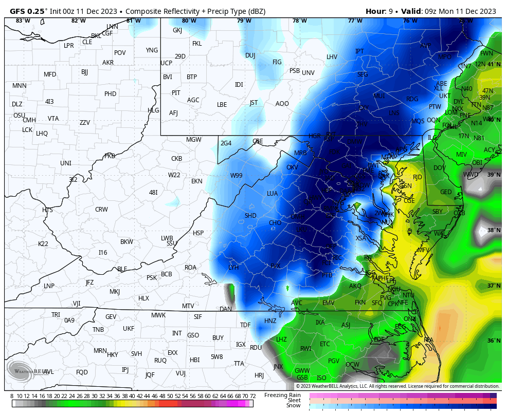
Snowing at blacksburg, it’s somewhat of a surprise.
-
7
-
-
51 minutes ago, Eskimo Joe said:
What website was that graphic generated from?
xmACIS2
-
1
-
-
25 minutes ago, Stormchaserchuck1 said:
Subsurface is really heating up. +5c over a large area according to the TAO/Triton maps, which is by far the greatest of the event so far.
And again, we aren't seeing cold water in the western subsurface, like other Strong events at this time of year. That could negate the tendency for us to automatically flip ENSO states next year.
How cold is the western subsurface normally in other strong events around this time? What’s the depth to watch, 0-300m?
-
3 hours ago, ldub23 said:
The long boring just continues. No winter last season, no cane season, and so far nothing this fall to say its going to be a cold winter with some snow.
Fall never really gives us anything to hint at a snowy winter here, models look much better than last winter already, so I’m hopeful for something better than last winter.
edit: and from what i’ve heard, late starts aren’t uncommon with niños, however, I haven’t looked at the stats for that.
-
1
-


December Mid/Long Range Discussion
in Mid Atlantic
Posted
So basically we want that jet to be further south?