

Rhino16
-
Posts
1,418 -
Joined
-
Last visited
Content Type
Profiles
Blogs
Forums
American Weather
Media Demo
Store
Gallery
Posts posted by Rhino16
-
-
32 minutes ago, RIC Airport said:
It's too bad the 18Z EPS only goes out to hour 144, everything looks good at 500mb. Snow maps only had a little east of the mountains through 18z on the 15th, but of course, that's not quite within range yet. Hopefully, all that means is that the 00z runs will be even more favorable.
If you have access to the median snowfall, can you post that too? It gives a better picture of the possibilities without the bigger members pushing the mean towards the max.
-
 1
1
-
-
That line looks very active as it approaches. Lots of activity over SW VA.
-
1
-
-
Just now, yoda said:
Northern Stream
Okay, I had that as an option. Thanks.
-
5 minutes ago, psuhoffman said:
Since my questions and tangents often seem to send the wrong impression...The 12z Guidance has been pretty good on the whole IMO. Don't let my quest to understand this one specific phenomenon skew the perception. I feel even better about our snow chances now than 2 hours ago. This is purely an attempt to understand something on my part.
I hate to ask, but NS is probably the last abbreviation I haven’t figured out. What does it stand for?
-
4 minutes ago, RIC Airport said:
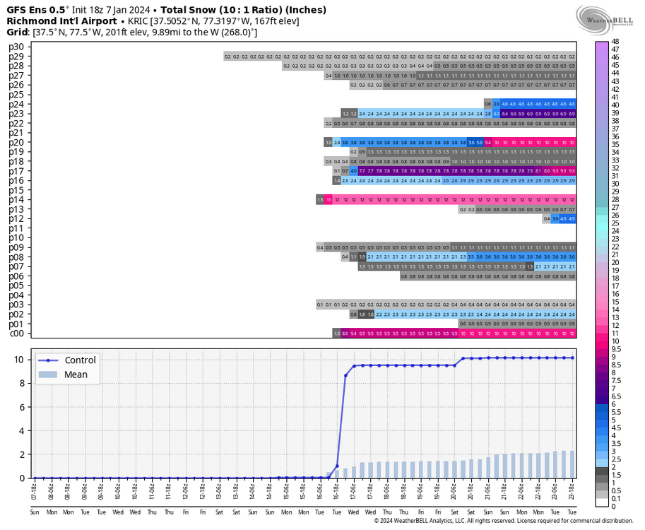
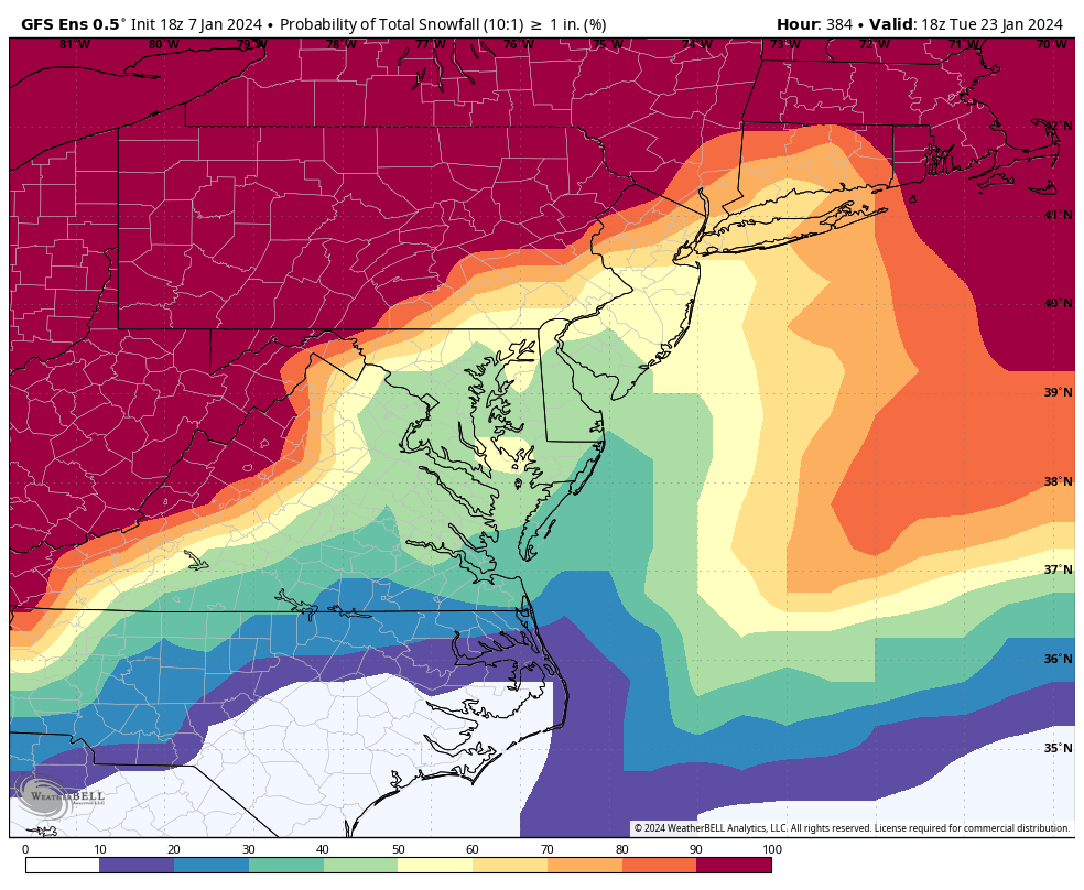
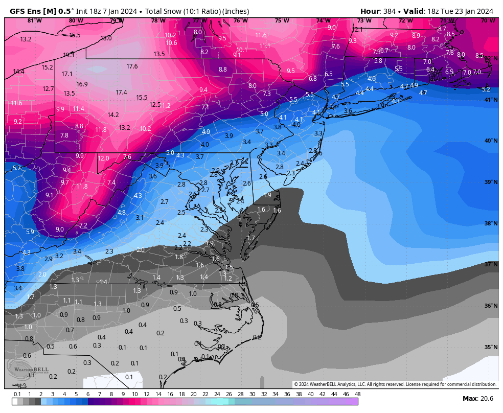
@Rhino16The 18Z GEFS was encouraging as it had several events, with the largest still appearing from the 16th to the 17th, while another shows up toward the 21st. The snowfall mean for the entire run was the highest I've seen in days, and the probability of getting 1 inch of snow, particularly for areas east of the mountains, is the highest I've seen all winter.


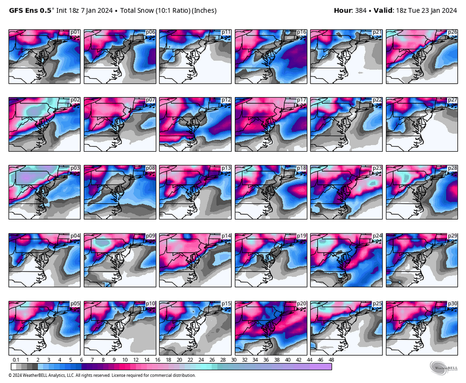
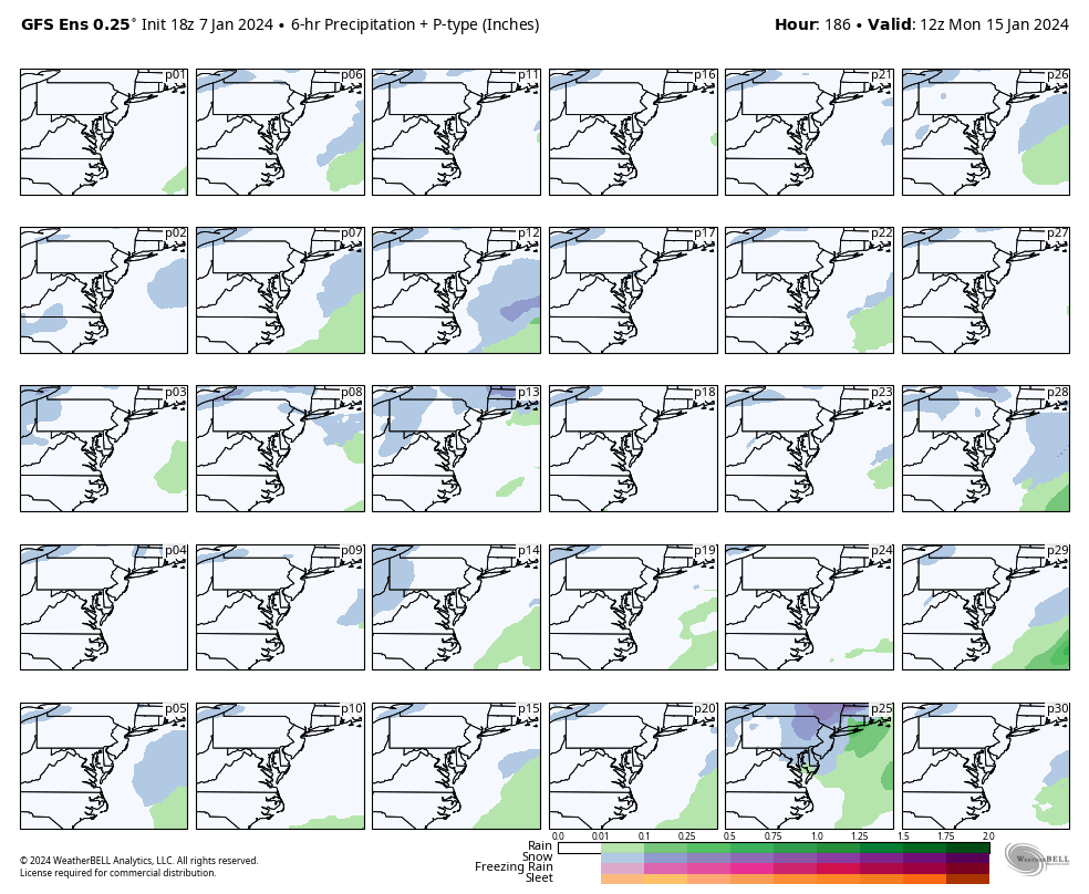
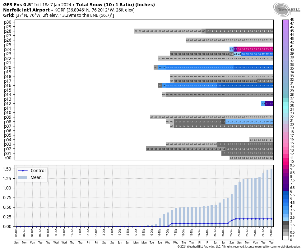
Regarding the 16-17th storm, the 18z GFS operational run was rainy for our area, with RIC reaching the low 50s (60s ORF), but many of its ensembles painted a colder scenario. In fact, there were several members that gave RIC at least 6" of snow. You can watch the hits below and see the charts for Richmond and Norfolk showing the member totals for the entire run.


I’ll allow a little sliver of hope for myself. I don’t know if I trust the GEFS ensembles being colder, but hopefully it’s right!
-
2
-
-
30 minutes ago, RIC Airport said:
12Z Euro has the storm, but it basically cuts to our west. But, we may be cold enough initially for some frozen especially north and west of RIC.


I think western storm track could be this winter’s top story.
-
 1
1
-
-
13 hours ago, Eskimo Joe said:
I hope it ages poorly and I have to eat a buffet of crow, but I could see DCA, PHL, IAD, and BWI pitching a shutout in the snowfall department after tomorrow.
Join us down here in RIC!
-
NAM is like the best run I’ve seen in 2 days… actually gets snow down here in Richmond.
-
 5
5
-
-
6 hours ago, WVclimo said:

Rip short pump
-
2
-
-
2 minutes ago, WinterWxLuvr said:
I like your use of the median
Me too, it’s really what we should be posting.
-
2
-
-
14 minutes ago, ers-wxman1 said:
Wrote about this yesterday. It is a mistake just to look at the model output, QPF etc. Analyze the scenario from the top down. 500/700/850. Are you seeing any features that align with known weather patterns that generate heavy snow across our area? Ridging out west, 850/700/500 energy is closed, deepening as it swings to our south? Strong high to the north? Blocking? Also with the CAD…what kind of air mass is being dammed? Nowhere in the northern tier do we see wind chill or extreme temperature headlines. These are flags. It’s been mild.
The big difference last night on the 00z I saw was the 850 low became closed and stronger with the vort passage, while the high became stronger, and more dynamics, ridging hinted over the western U.S. that amplifies things enough to deepen the surface low in the right spot, however this isn’t slam dunk. It’s all marginal and not dealing with a textbook winter storm here, so any minor shift in these subtle features will significantly alter snowfall amounts. That is what is happening. It’s simply not the ideal pattern. It would be a heavy front end thump then hope for wrap around as it winds up offshore before subsidence kicks in. Many moving parts. Strong SW upper flow makes this fast moving system, rely on front end WAA. Thermals also marginal, no good source to fuel this. These types of systems are a nightmare to forecast, especially with regard to headlines and where to put them.
Top down forecasting! Very important technique to use for winter especially.
-
2
-
-
Winter is over here in Richmond (I’ll be saying it’s back next week). Glad I get to spend it in the mountains learning about winter.
-
-0.2 _ -0.6 _ -0.8 __ +1.0 _ -0.4 _ 0.0 __ -0.7 _ -0.6 _ +1.2
-
This is over for us. I just don’t see that big of a change in modeling this close to it. Was thinking this yesterday.
-
1
-
1
-
-
6 minutes ago, Weather Will said:

Thank you! I’ll take some mood flakes I guess before it gets washed away. Even if it stings.
-
1 minute ago, Weather Will said:
WB 18Z GEFS probs and mean.


What about the 1” odds, if they exist? The 3” is too low for down here in Richmond…
-
2 minutes ago, Conway7305 said:
there is still some big hitters in there
Remember it’s not been updated yet from what I can tell, so it might not have the greatest depiction of things. The NAEFS was upgraded recently, but I don’t know what that is…
-
Very disappointing, but hopefully it’s wrong.
-
2
-
-
Looking through some of the soundings, I think I’d be on the snow side of the line, it just shows rain because of low resolution.
-
1 hour ago, WxUSAF said:
It’s one of the few nights per year where I’ll actually be up for the 0z gfs. It better be good.
Rooting for everyone up there…
-
3 minutes ago, nj2va said:

Of course it will snow at school while everyone’s gone… hopefully plenty of opportunities to come though…
-
6 hours ago, psuhoffman said:
Super Nino in 2016 may have been a tipping point. Warmer the pacific past a point at which can be overcome by other factors. Just speculation though.
Would a ton of Niñas work to balance that out again? Or does it not work that way?
-
2 minutes ago, clskinsfan said:
I dont think any of us are saying that. What we may be saying is that nickle and dime snows may very well be a thing of the past. And we either get bombs or we get squat. And that alone is a scary thing to face.
Is that not a typical Niño year around here anyways?
-
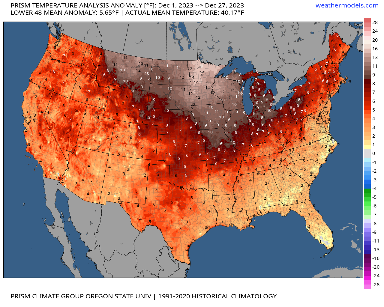
5 hours ago, RIC Airport said:
And RIC is at +3.6. In fact, yesterday and the day before were +16 and +12, respectively, from their daily average. To put yesterday's +16 into perspective, the last time Richmond had a daily departure of -16 or lower was on Christmas Eve 2022, when the low temperature was 8°F, and the high was only 24°F, which was a -24 departure from average. We don't seem to get those negative departures as often anymore.
So yes, It's been a warm month, although our part of the CONUS looks to have been spared the worst.
Also, through yesterday, Norfolk had received 6.34" of rain, which makes December 2023 the second wettest December on record. The wettest, December 2009, had 7.57" and appears safe as the latest models only have up to about 0.10 to 0.25" at best through ORF through the end of the year.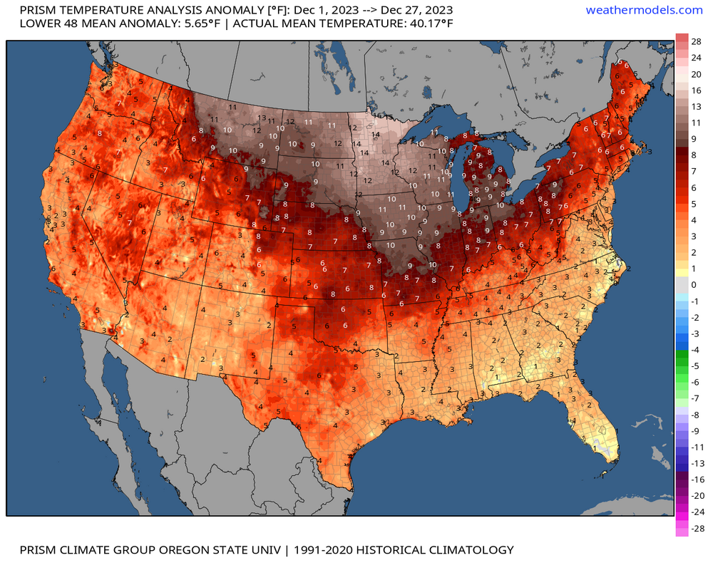
Also, Norfolk is moving toward its top 10 stretches of days with less than 1 inch of snow.
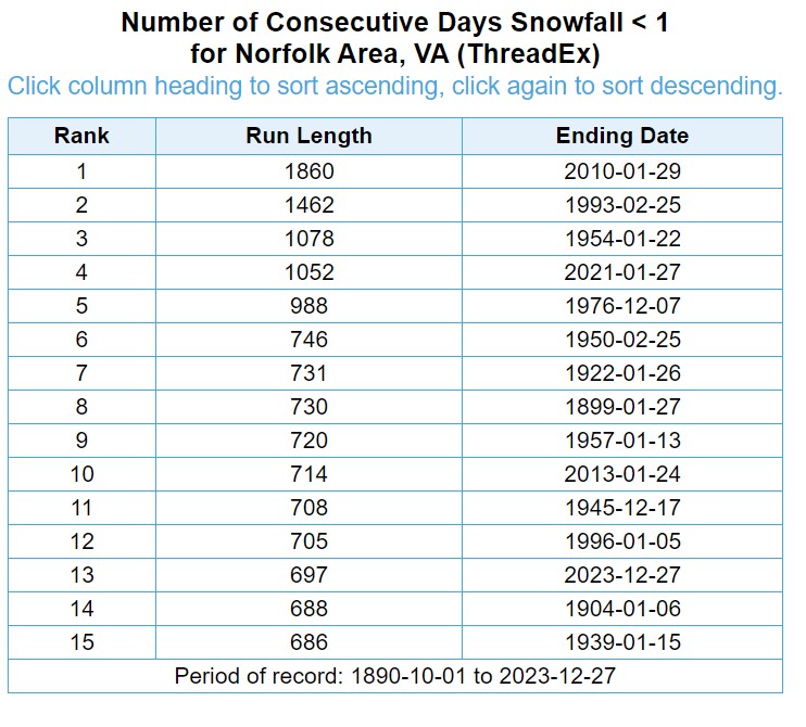
The 7.57” deserves to stay because that’s too perfect!
-
1
-


Richmond Metro/Hampton Roads Area Discussion
in Mid Atlantic
Posted
I agree It’s definitely the windiest of the day currently!
As for the median, I don’t think they use the word median, but instead call it 50th percentile or something, if it helps.