

STxVortex
-
Posts
196 -
Joined
-
Last visited
Content Type
Profiles
Blogs
Forums
American Weather
Media Demo
Store
Gallery
Everything posted by STxVortex
-
Kelly Field is about 700+ miles away from Ida, long enough, 2hrs+. They're at 700mb fl, big pressure drop and wind increases, heading 135deg ~40nm out of eye.
-
AF303 reconn entered Ida from the NNW, has slowed down and descended a little, is now heading due south to the eye, about 50-60nm away. As of 04:27 UTC Aug 29, 2021: Aircraft Position: 28.07°N 89.08°W Bearing: 180° at 120 kt Altitude: 3136 gpm Peak 10-second Wind: 57 kt at 64° Extrapolated Sea-level Pressure: 1003.0 mb https://www.tropicaltidbits.com/recon/
-
Grand Isle bullseye methinks. 0407utc AF303 descended to 3200m and turned the pressure sensors on. Picking up edge conditions, ~1.2deg long/70nm away from Ida's core.
-
Levi's reconn page just got unstuck, 0347utc. AF 303 just entering outer edge of Ida. Potential problem is the MSLP reading /sensor stopped shortly after takeoff [or was turned off?].
-
Ida is lighting off the afterburners. Dr. Cowan's aircraft reconn page has been stuck at 0317utc for 1/2h+. But from the last fix AF303 Mission #12 should only be ~20 minutes out from Ida's core.
-
Well it's Saturday afternoon, you have time yet to have some pre-funeral flowers delivered. Such activities won't be possible by tomorrow for some weeks.
-
Well, at least one dedicated stormchaser is apparently back in the hunt, for Zeta this time. I'm effing jealous, dammit ;] . [edit-- I'm surprised he was able to get another rental vehicle --]
-
I'd be inclined to minimize those models. The NHC is already progging a LA Delta landfall at hurricane strength, which is a slight bump up from earlier forecasts. They now show Zeta at hurricane strength clear across the GOM. The 1700 Forecast Discussion will have the details. https://www.nhc.noaa.gov/refresh/graphics_at3+shtml/180131.shtml?cone#contents
-
Requesting a little information. I'm aware that [most of?] the Hurricane Hunter [53rd Weather Reconnaissance Squadron "Hurricane Hunters"] operations are currently based at JBSA Lackland in San Antonio. At ~0647h this morning a heavy prop-driven aircraft passed nearly over my house, a rare event [with a 'heavy', normally lots of AF trainers and jets, helos many days ]. Due to socked in local WX thanks to Delta, I didn't see it, low dense ceiling, aviation sounds get tricky. So, I've been digging around at Tropical Tidbits and the USAF HH web [see below]. There was data indicating "AF303 Mission #20 into DELTA" was very close to my location at 1147Z. Hot Damn! this innartoobs stuff is effing amazing [--been in what is now IT/computers since 1969... ;] ]. Can someone verify and let me know if the AF303 equipment was a WC-130J Hercules ? And perhaps what it's altitude, etc. was? It's been interesting sensing Delta's subtle effects on our local weather since ~Tuesday, wind slowly backing SE to N/NW, cloud layers, barometric, etc. Partial data: https://tropicaltidbits.com/recon/ [Thanks LC] "AF303 Mission #18 into DELTA Type: Low-level Reconnaissance | Status: Finished As of 11:47 UTC Oct 09, 2020: Aircraft Position: 29.20°N 98.20°W Bearing: 270° at 314 kt Altitude: 1766 gpm [gpm? has slipped my mind what this is] Peak 10-second Wind: 17 kt at 49° Extrapolated Sea-level Pressure: N/A Aircraft Data Time Series (click to enlarge):" https://tropicaltidbits.com/data/recon_AF303-1826A-DELTA.txt "... 114200 2908N 09741W 5447 05182 0247 -023 //// 038003 006 /// /// 05 114230 2909N 09744W 5602 04967 //// -031 //// 005012 015 /// /// 05 114300 2910N 09747W 5845 04626 //// -013 //// 011015 015 /// /// 05 114330 2911N 09750W 6086 04302 //// +009 //// 007015 015 /// /// 05 114400 2911N 09753W 6324 03992 //// +032 //// 011016 016 /// /// 05 114430 2911N 09755W 6581 03667 //// +056 //// 024015 016 /// /// 05 114500 2911N 09758W 6845 03344 //// +080 //// 032016 016 /// /// 05 114530 2911N 09801W 7118 03020 //// +091 //// 036017 017 /// /// 05 114600 2911N 09804W 7392 02706 //// +104 //// 033017 018 /// /// 05 114630 2911N 09807W 7673 02392 //// +123 //// 035015 016 /// /// 05 114700 2912N 09809W 7959 02083 //// +141 //// 028014 014 /// /// 05 114730 2912N 09812W 8262 01766 //// +152 //// 049016 017 /// /// 05" [series appears to end here, not too far away ] https://www.403wg.afrc.af.mil/About/Fact-Sheets/Display/Article/192529/53rd-weather-reconnaissance-squadron-hurricane-hunters/ Thanks y'all .
-
YBMTI. I saw that, and was going to comment that it had contracted ~20% [35-28] from recent reports.
-
Thanks LPL. That southern outflow 'tail' really looked impressive in the various satellite animations when I could see them. Have two usual probs, first, when I downloaded the sat 'gifs', they were just a little bigger than AmWX allows as an upload [~1.95Mb? for me], so couldn't post the animation myself [sometimes can]. My second prob is a highly variable IP connection, ranges from 16Kbps to 3-6Mbps, which severely affects my use of image -intensive websites like this. Gonna dodge Delta here methinks.
-
Delta's southern outflow arm is streaming into the Pacific Gulf of Tehuantepec [as if pulled]; using the NHC/NESDIS GOES16 Geocolor image, which is too big to insert here [tried various ways?]. The northern outflow doesn't seem as defined or vigorous, may account for the slower development? Delta has also been making a more westerly course than progged, this worries me here in Coastal Bend Texas; the extra westering may scootch the ultimate track over too far for us. Do I need to give the boat the full 'batten down' in the slip, schedule a haulout? Decisions decisions ...
-
Me too, plus a few other bands I been perusing. https://www.star.nesdis.noaa.gov/goes/floater.php?stormid=AL262020
-
Been doing some comparisons of GOES satellite imagery between Delta and good ol' Harvey. Both came off the Yucatan on a similar track, it's a month and a half later in the season for Delta, SSTs a bit lower now, Harvey was much weaker until well into the GOM [and almost invisible in the NW Carib, unlike Delta's RI there], and was somewhat smaller at this point in it's cycle life, not enveloping the whole GOM as Delta is beginning to. So, Delta is already stoked, related atmospherics are filling the entire GOM att, and Delta appears set for some rebound RI for the next 24-72 hours. In short, Delta may be a demon cyclone after all.
-
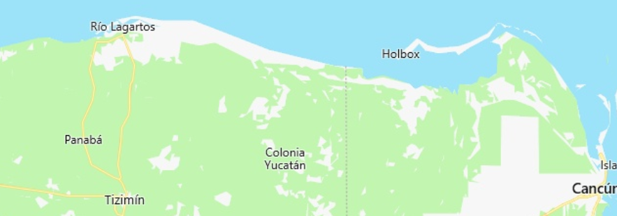
The eye/center of Hurricane Delta is just about over Rio Lagartos per the 10AM NHC report: Rio Lagartos, Coordinates: 21°36′N 88°10′W https://en.wikipedia.org/wiki/Río_Lagartos WTNT31 KNHC 071449 TCPAT1 BULLETIN Hurricane Delta Advisory Number 12 NWS National Hurricane Center Miami FL AL262020 1000 AM CDT Wed Oct 07 2020 ...CENTER OF DELTA ABOUT TO EMERGE OFF THE NORTHERN COAST OF THE YUCATAN PENINSULA... ...STORM SURGE AND HURRICANE WATCHES ISSUED FOR PORTIONS OF THE NORTHWESTERN AND NORTHERN GULF COAST... SUMMARY OF 1000 AM CDT...1500 UTC...INFORMATION ----------------------------------------------- LOCATION...21.4N 88.0W ABOUT 65 MI...105 KM WSW OF CABO CATOCHE MEXICO ABOUT 110 MI...175 KM E OF PROGRESO MEXICO MAXIMUM SUSTAINED WINDS...105 MPH...165 KM/H PRESENT MOVEMENT...NW OR 305 DEGREES AT 17 MPH...28 KM/H MINIMUM CENTRAL PRESSURE...975 MB...28.80 INCHES
-
Given the 7AM NHC Public Advisory, the eye of Delta should be entering the GOM near Rio Lagartos, Yucatan in an hour or two [Rio Lagartos is due north of Tizimin, and at the northern midpoint of the Yucatan. SUMMARY OF 700 AM CDT...1200 UTC...INFORMATION ---------------------------------------------- LOCATION...21.1N 87.4W ABOUT 35 MI...55 KM W OF CANCUN MEXICO MAXIMUM SUSTAINED WINDS...105 MPH...165 KM/H PRESENT MOVEMENT...NW OR 305 DEGREES AT 17 MPH...28 KM/H MINIMUM CENTRAL PRESSURE...974 MB...28.76 INCHES
-
609 WTNT61 KNHC 071054 CCA TCUAT1 Hurricane Delta Tropical Cyclone Update...Corrected NWS National Hurricane Center Miami FL AL262020 545 AM CDT Wed Oct 07 2020 Corrected header time and time in the summary block ...DELTA MAKES LANDFALL ALONG THE NORTHEASTERN COAST OF THE YUCATAN PENINSULA NEAR PUERTO MORELOS... Satellite imagery, radar data from Cuba, and surface observations in Mexico indicate that the center of Delta has made landfall along the northeastern coast of the Yucatan Peninsula near Puerto Morelos around 5:30 AM CDT (1030 UTC) with estimated maximum winds of 110 mph (175 km/h), a category two hurricane on the Saffir-Simpson Hurricane Wind Scale. A WeatherFlow observing site near Puerto Morales recently reported near calm winds and a minimum pressure of 972 MB (28.71 inches) in the center. A WeatherFlow observing site near Cancun has reported peak sustained winds of 84 mph (135 km/h) with a gust to 106 mph (170 km/h). SUMMARY OF 545 AM CDT...1045 UTC...INFORMATION --------------------------------------------------- LOCATION...20.8N 86.9W ABOUT 20 MI...35 KM S OF CANCUN MEXICO MAXIMUM SUSTAINED WINDS...110 MPH...175 KM/H PRESENT MOVEMENT...NW OR 305 DEGREES AT 17 MPH...28 KM/H MINIMUM CENTRAL PRESSURE...972 MB...28.71 INCHES $$ Forecaster Brown
-
My SWAG regarding the residual effects of TS Gamma are that the huge amounts of precip Gamma recently dumped on the Yucatan will cause Delta to experience a much-lessened 'land effect' weakening period than might be expected or modeled [do any models even factor in something like that?]. And perhaps possibly even an intensity increasing "Brownwater Effect"... Of course, having previously traveled the Yucatan extensively, I suspect the mostly limestone and sandy terrain won't hold much standing water for long.
-
FYI- I suspect that comment by tzav77 above, with the 'bitly' links, may be a potentially nasty viral trap. Admins should check it out, safely of course. Nobody should ever trust those re-directive 'abbreviated' links on a public board from an unknown poster.
-
Given the NHC's current discussion, Delta could be a Cat 5 [157mph sw] when it hits the Cozumel, Cancun Yucatan, Quintana Roo areas. The 5PM Discussion only needs a 2mph bump at 12H mark. NHC forecast [models synthesis] has also gradually bumped the northern GOM approach and landfall intensity up as they move the projected track westward, now showing 'Major' status at landfall, it had previously lost that rating mid-GOM. Hurricane Delta may be yet another record-setter. And the season still has seven weeks to run. "064 WTNT41 KNHC 062034 TCDAT1 Hurricane Delta Discussion Number 9 NWS National Hurricane Center Miami FL AL262020 500 PM EDT Tue Oct 06 2020... FORECAST POSITIONS AND MAX WINDS INIT 06/2100Z 18.9N 84.1W 125 KT 145 MPH 12H 07/0600Z 20.2N 86.1W 135 KT 155 MPH 24H 07/1800Z 21.8N 88.8W 105 KT 120 MPH 36H 08/0600Z 23.0N 91.1W 110 KT 125 MPH 48H 08/1800Z 24.4N 92.6W 115 KT 130 MPH 60H 09/0600Z 25.9N 93.2W 115 KT 130 MPH 72H 09/1800Z 28.0N 92.9W 110 KT 125 MPH
-
Well, TS Beta is about 6nm closer, pretty much the same wx with brisk NW winds. If that big ball of precip well N of Victoria holds together it might get wet here in a couple of hours. "7:00 AM CDT Tue Sep 22 Location: 28.8°N 96.8°W Moving: NW at 3 mph Min pressure: 999 mb Max sustained: 40 mph "
.gif.3ab0d1da21fc0432e071565616d3b0f3.gif)
-
Kind of quiet here for an active storm. TS Beta is meandering about 94sm to the ESE of me [as of the NHC 0400h reports]. The wind has now backed to the NW and brisk. Yesterday morning brought gusty NE/ENE winds and an inch or two of precip in rainbands, tapering off and intermittent since. CRP radar showing much less precip att, one large patch N of Victoria might swing over here in the weakening rotation. Except for the significant rain accumulations towards Houston, good ol' Beta kind of fizzled. It is following a sort of Harvey-ish track though, but with just a small fraction of Harvey's ACE. "4:00 AM CDT Tue Sep 22 Location: 28.8°N 96.7°W Moving: NW at 3 mph Min pressure: 999 mb Max sustained: 40 mph"
-
Another very respected scientist and leader stands up for the good people of NOAA, and [too, imo] politely excoriates the incompetent, and sycophantic, who cravenly interfere with the scientists and technicians of NOAA. From the "Scientific American" * : Observations - Leadership In The Age Of The Surreal "Leadership in the Age of the Surreal The professionals at the National Weather Service deserve political leadership that will stand up for them—even when that puts the leaders’ own jobs in jeopardy. .Over the past two weeks, Hurricane Dorian destroyed portions of the Bahamas and posed a major threat to the southeastern U.S., before eventually making landfall in North Carolina. Given that we are in peak hurricane season, this is not an unprecedented story. In today’s age, however, the devastating hurricane became a backdrop to a political farce that, even in retrospect, seems unbelievable. ... [read the whole article at the link] ABOUT THE AUTHOR(S) David Titley David Titley is an affiliate professor of meteorology at Penn State University; Rear Admiral, U.S. Navy (retired); former oceanographer of the navy; former Chief Operating Officer for the National Oceanic and Atmospheric Administration; and a member of the Governing Board at the Center for Climate and Security. [ * The "Scientific American", I began subscribing to it ~c. 1968 ]
-
No rational, logical, science-related or based US government policies will be possible until the place is cleaned up, reformed, until the 'swamp' is truly drained out. It's currently mostly controlled by and for anti-science, anti-factual, cultist grifters who act on a far different plane than a patriotic 'for the good of the nation' basis; when not acting on behalf of foreign interests [like RU, MbS, DPRK, etc].
-
An apt quote, but you should attribute it to George Orwell's great [and scary] book, "1984", which I think too few today are aware of. Yet, here we are, nearly living in it. Nineteen Eighty-Four: A Novel, often published as "1984" George Orwell presented a situation where people struggle to live in a atmosphere of deceit under the pervasive rule of "Big Brother". An atmosphere of deceit where "that which is truth" is totally controlled by an authoritatively positioned ruling party. “What you’re seeing and what you’re reading is not what’s happening”


