

crossbowftw3
-
Posts
1,394 -
Joined
-
Last visited
Content Type
Profiles
Blogs
Forums
American Weather
Media Demo
Store
Gallery
Everything posted by crossbowftw3
-
Summer 2020 Banter and random observations
crossbowftw3 replied to Baroclinic Zone's topic in New England
Yeah, last year's event had that 15 hatched tornado/45 hail but here its just a 15 hail (for early stage storms) and a large 5% tornado; thinking early storms could indeed have that chance for a strong tornado or two before things grow upscale, likely within 2-3 hours of what I think should be rather rapid CI -
Summer 2020 Banter and random observations
crossbowftw3 replied to Baroclinic Zone's topic in New England
DCAPES 1200-1300 as well, strong shear profiles, it's gonna look last July 19th all over again -
Summer 2020 Banter and random observations
crossbowftw3 replied to Baroclinic Zone's topic in New England
I sense a PDS Severe Watch across the UMW later...7000 SBCAPE pooling across SE ND already 86/81 at KGWR with is co-located with the 7000 CAPE -
1630 outlook further expands the moderate risk into NW Wisconsin, with rather concerning wording at hand. 7000 SBCAPE pooling in SE ND already. https://www.spc.noaa.gov/products/outlook/day1otlk.html
-
2020 Mid-Atlantic Severe Weather - General Thread
crossbowftw3 replied to Kmlwx's topic in Mid Atlantic
6/3/14 for wind, hail cannot go past moderate. most recent PDS severe watch happened August last year. -
2020 Mid-Atlantic Severe Weather - General Thread
crossbowftw3 replied to Kmlwx's topic in Mid Atlantic
The case of lower Michigan might be one where a PDS severe watch is warranted only if the tornado threat was slightly lower. It's still entirely plausible under current circumstances, however. For us further east folk it looks like limited forcing today. -
Upstate/Eastern New York
crossbowftw3 replied to BuffaloWeather's topic in Upstate New York/Pennsylvania
Severe warning for Yates for hail. Storm looks elevated so wind probably isn't a problem there but count on 1" hail possibly. -
Upstate/Eastern New York
crossbowftw3 replied to BuffaloWeather's topic in Upstate New York/Pennsylvania
Changeover has finally arrived for me -
Upstate/Eastern New York
crossbowftw3 replied to BuffaloWeather's topic in Upstate New York/Pennsylvania
Still stuck at 40/38 but the changeover is encroaching on me quickly. Still praying for 1" before the precip shuts off by around Midnight. -
Upstate/Eastern New York
crossbowftw3 replied to BuffaloWeather's topic in Upstate New York/Pennsylvania
Looks like my switch could commence later next week. 10 day forecast slowly surges us up until we hit near-70 by next Saturday and only goes up from there. -
Upstate/Eastern New York
crossbowftw3 replied to BuffaloWeather's topic in Upstate New York/Pennsylvania
Hoping for the best with the squalls. Regardless by Memorial Day we'll all be installing our Air Conditioners and this'll be but a passing memory in the wind as we roast in 80 degree/65+ dew point heat -
Upstate/Eastern New York
crossbowftw3 replied to BuffaloWeather's topic in Upstate New York/Pennsylvania
Pretty much praying for an inch now but tomorrow's squalls look more juicy anyway. Gonna feel like a mid winter day even in between the possible squalls. Hoping whoever has to go on the roads are ready for them. -
Upstate/Eastern New York
crossbowftw3 replied to BuffaloWeather's topic in Upstate New York/Pennsylvania
Still count on a burst of snow but the writing on the wall was pretty evident -
Upstate/Eastern New York
crossbowftw3 replied to BuffaloWeather's topic in Upstate New York/Pennsylvania
18z Euro is (probably) the final nail in the coffin.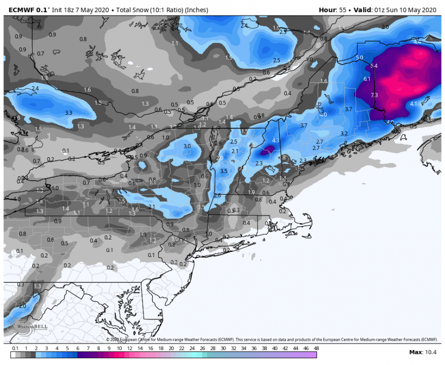
-
Upstate/Eastern New York
crossbowftw3 replied to BuffaloWeather's topic in Upstate New York/Pennsylvania
Overall though the models are slowly moving away from a more widespread heavier snow which makes sense. still not counting on much more than a 1-3/3-5 deal, yet that doesn't matter as it'll for certain be the latest I've seen snow on record. -
Upstate/Eastern New York
crossbowftw3 replied to BuffaloWeather's topic in Upstate New York/Pennsylvania
It'll be incredibly eye opening if I wake up to a white ground Saturday. I think north of me and closer to BGM is likely where you move past in air and into accumulations. Razor thin line between accumulations and nothing. -
Upstate/Eastern New York
crossbowftw3 replied to BuffaloWeather's topic in Upstate New York/Pennsylvania
At my elevation not counting for more than 2", considering....but holy cow, never did I expect to be facing snow this late. I thought the snow from the 19th last month was absurd. -
It is. coincidentally on the same date as Lee County from last year.
-
No longer waiting for Cookeville. EF4 with winds of 175.
-
Hearing from other forums that Tennessee EMA Spokesperson now indicating at least 28 deaths, 200+ injured.

