crossbowftw3
-
Posts
1,394 -
Joined
-
Last visited
Content Type
Profiles
Blogs
Forums
American Weather
Media Demo
Store
Gallery
Everything posted by crossbowftw3
-
Only 397,000 left to get there. Get that chainsaw whirring now, Kevin
-
High and dry in the Catskills. Strangely feels cool and not exactly humid at the moment. First bands aren’t rotating in until Lunch or maybe after. Almost no wind threat now which is great to see but...
-
not much wind but potential for a lot of rain
-
The current feel outside is certainly playing the part of incoming TC. Not liking how things are looking with rain potential now—first IVT rains pushing in.
-
Go east, young man

-
Hoping that PRE does not make it here to Sullivan tonight because that’s just asking for trouble tomorrow.
-
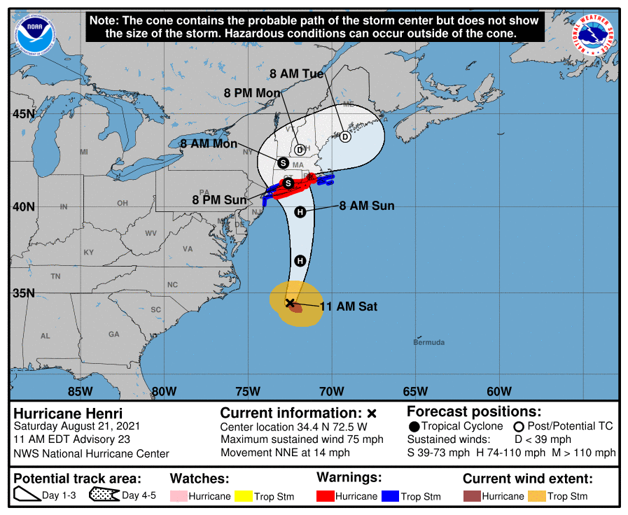
8PM cone perhaps nudged the tiniest bit further east.
-
How long until we see images of cats and dogs living together in the flooded apartments? Asking for a friend.
-
If it happens during winter, the cold. Houses will quickly get cold without heat.
-
Under 12 but much closer to maybe 6-8 hours
-
FFWatches finally populating here inland. 2-4” which is reasonable.
-
The king of Mount Tolland.
-
Wake me up when the next 12” in 90 minutes blizzard happens.
- 1,603 replies
-
- 1
-

-
- hurricane gusts
- flooding rains
- (and 2 more)
-
Forgive us for most of that is just Kevin wishcasting. This will still be a major problem along and east of the track, however
-
85 MPH maximum sustained with the east trend reflected on the new cone.
- 1,603 replies
-
- 1
-
-
- hurricane gusts
- flooding rains
- (and 2 more)
-
Some organization should still happen (as the warmest Gulf Stream waters lay ahead) but you would be correct, time is running very thin
-
Fire up the chainsaw because you’ve got a lot of trees to knock down
-
Earth, Wind and Fire?
-
NAM is East. Can’t trust the NAM but at the same time the East trend is keeping up.
- 1,603 replies
-
- 1
-
-
- hurricane gusts
- flooding rains
- (and 2 more)
-
Sustained TS force easily but I would assume some Hurricane Force gusts may be seen even if this thing does not come ashore as a hurricane.
-
The window for more significant intensification is likely gone now considering though mid-range cat 1 is about the limit for this thing over the next 12 hours before its residency time over the Gulf Stream ends.
-
Maybe 12 hours left to strengthen before coming into cooler waters. Twin Forks seems like the place to be for this to come ashore.
-
BGM early call is 2-3” for its eastern CWA. We should see changes up or down today.
- 1,603 replies
-
- 1
-

-
- hurricane gusts
- flooding rains
- (and 2 more)
-
And at fairly incredible pace too, all things considered, from where it was 12-18 hours ago
-
Big sense now that most of CT is in trouble. Whether it’s eastern or western third (likely both) needs to be resolved in the next 18-24 hours.