

Kmlwx
-
Posts
12,667 -
Joined
-
Last visited
Content Type
Profiles
Blogs
Forums
American Weather
Media Demo
Store
Gallery
Posts posted by Kmlwx
-
-
6 minutes ago, high risk said:
There will be no upgrades to the HRRR since it's slated for retirement.
Now I recall hearing that. Guess we'll just have to keep assuming it is overtaxing in these situations.
-
 1
1
-
-
12z ARW2 brings some cells/line through around 5 or 6 and then has a rogue super cellular type thing doing what @Eskimo Joe mentioned earlier lol
ETA: It shows it in the 02-04z timeframe.
-
I hope they have a fix for the HRRR over mixing in the works. It seems to do it EVERY time.
-
3
-
-
1 hour ago, high risk said:
That's mostly how I see it too. I'll disagree on round 1 being "weak" - the HRRR simulated reflectivities are fine; isolated SVR seems likely, but I question the TOR threat with the weaker low-level winds. Shear cranks up after dark, but we'll be fighting decreasing instability. To me, the biggest potential overlap between increasing shear and still-sufficient sfc-based instability will be northwest of the DC area.
Model soundings seem to still show a decent amount of CAPE overnight - but also have some CINH as well as can be expected. Probably if nothing else a good light show overnight.
-
Most of the guidance seems to be in agreement that there may be a late afternoon/evening round of showers/storms - but much of the guidance is pretty weak with that stuff. NAM and RAP seem to think best parameters may actually show up during the 3z-6z window...while it will suck for daylight, it's possible this can still perform. Wonder if the CAPE will remain surface based that late, though...may end up being elevated (admittedly I haven't looked closely at the soundings).
I'm not very intrigued for the early round...and I do wonder if that is going to stabilize some areas too much to have the nighttime round of storms.
Another storm day when I'm at work all day....
-
It's way out there - but the 12z Euro has a sub-1000mb low pressure passing around the Great Lakes next Monday. it actually deepens it to 996mb by 6z Tuesday. There's some CAPE available Monday on the model too - with significant bulk shear as well. That bears watching.
The 12z GFS has some threat indicated Sun and Mon but the low looks pretty different/not as deep.
-
2
-
-
4 minutes ago, mappy said:
Kiddo's camp is closed today, so we packed up and went to Hunt Valley where my office has power. So many trees down in Parkton. Power was out as far south as Hereford before we jumped off York and got on 83.
A coffee from CFA never tasted so good.
Hope the power is back ASAP!
Power outages can be fun as a kid - and maybe are a little interesting for the first hour or so as an adult...but after that things get pretty blah fast.
-
Massive downpour here now
-
Southern Maryland cell is trying for a last hurrah.
-
1
-
-
Just now, Eskimo Joe said:
I'd imagine LWX is so busy slinging warnings they can't LSR everything right now.
It's definitely this. Populated areas - even with moderate storms tend to lay down a few LSRs.
-
Have to imagine they are coordinating/discussing with local WFOs.
Have folks at work that are antsy for my midday update for them - wanted to see the 12:30 SPC update before giving them the update.
-
2
-
-
Refreshing the CoD SPC page like crazy...
-
1
-
 6
6
-
 1
1
-
-
That LWX Special Weather Statement is a hint that they MAY have conferenced with SPC and some changes may be coming to the 1630z SPC update. Not saying definitely...but maybe an enhancement of the TOR probs. We'll see soon.
-
4
-
-
Walked by a window at work - and there's still plenty of clouds but with a few sunny breaks in the Rockville/Potomac area.
-
Visible satellite shows steady thinning of the cloud cover.
-
3
-
-
I'm in favor of keeping it all here - while it turns into a mega-thread most years - it's a one stop shop for those wishing to go back through prior year's severe events. I know we used to separate into threads - but it's tougher to search those out than a single thread. And I don't think the forum struggles with large threads as much as it used to.
-
2
-
 1
1
-
-
I'm fully on board with today at this point. To quote Twister....
Let's all grab our ankles and stick our butts up in the air during the storms! Best place to be struck!
-
2
-
3
-
-
Just now, Eskimo Joe said:
The low clouds almost show up like CAD.
-
I am angling to get out of work early...hope we don't start seeing radar blowing up too early. Because getting out prior to 3:30 is looking like a losing battle...unless by some miracle my firm decides to be lenient with liberal leave or something. I've messaged as best as I could to the powers that be (I'm the company weather person lol)
-
3
-
-
Just now, Eskimo Joe said:
Yup. SPC high risk days seem to be focused on tornadoes, and that's fine. I still think the 2012 Derecho should've been a hatched 60%.
Agreed - though it seemed like it was super "on the fly" in terms of how the upgrade happened. Wonder if that played a role - and up until the bitter end it seemed like there was low confidence in the intense strength being maintained this far east.
-
1
-
-
As others have said - it's probable that given the synoptic forcing for later - we don't need extreme instability. I think the clearing of the low junk essentially is more of a determining factor as to whether we get something that we talk about for years versus a decent storm/iso severe day. Of course, microscale stuff could still lead to people getting missed (as is always the case) - but a total dud seems nearly off the table at this point.
-
4
-
-
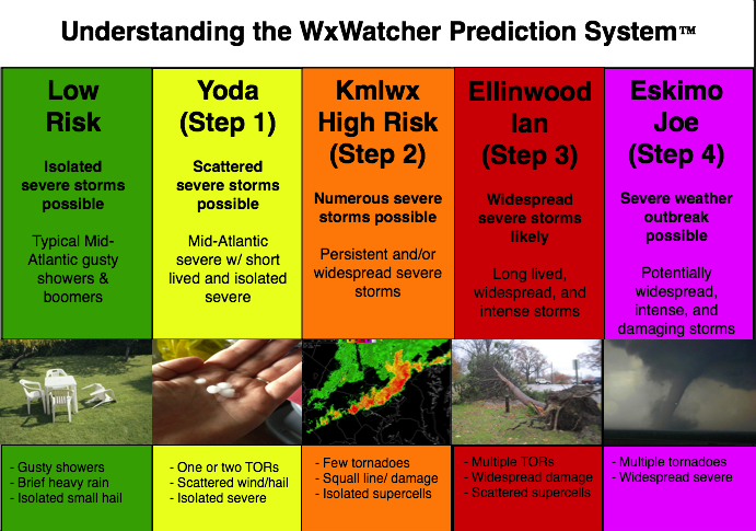
We've gotta figure out where we are on the scale

Some might argue we're at 3 but maybe we are close to a 4?!
-
2
-
3
-
-
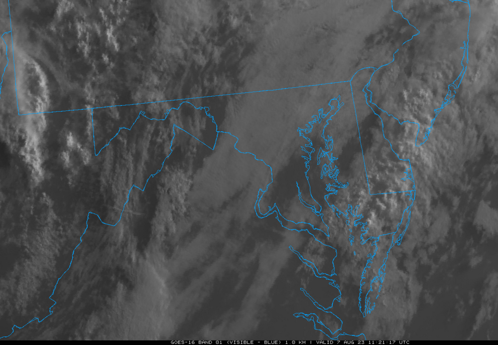
Worth noting that if you animate that - all of the low clouds over the metro area appear to be just low clouds - may be easy to burn those off as long as clouds to the west don't come in to complicate things.
-
5
-
-
That chase area tends to do very well!
-
1
-

2023 Mid-Atlantic Severe Wx Thread (General Discussion)
in Mid Atlantic
Posted
The 23z HRRR gets northern Maryland with some activity overnight but seems it doesn't like the threat of an overnight batch as much (or at all) like some prior runs wanted to fire up.