

Kmlwx
-
Posts
12,667 -
Joined
-
Last visited
Content Type
Profiles
Blogs
Forums
American Weather
Media Demo
Store
Gallery
Posts posted by Kmlwx
-
-
There are some cases when morning showers or convection (if it clears early enough) can actually juice up dew points and also lay down boundaries to enhance later activity. But it's always a game of balance.
-
 2
2
-
-
2 minutes ago, high risk said:
The previous dozen posts discussing the higher end potential for tomorrow aren't enough for you?
")
We have to strive to get this thread as active as this place gets 12 hours before a 30+ inch snowstorm.
-
5
-
 3
3
-
-
I'm tentatively in - parameters look pretty good for this region...our usual suspect (potential morning spoilage) will of course be in play. Won't know for sure my "in or out" status until that becomes more clear tomorrow. But I like where things stand for some excitement in the region.
I love how this stuff tends to happen either when I'm out of the area or going to be in the office. Wish Mother Nature would hold off until my WFH days...
Sent my weather email to the interested folks at work...maybe they'll let us WFH tomorrow afternoon but I doubt it.
-
5
-
-
Some nice UH swaths over the area for Monday on that 12z NAM nest run.
-
1
-
-
38 minutes ago, yoda said:
While true, I don't think I've seen LWX in their AFD mention tornado threat 4 days out
The potential for severe weather is still there, though. Model
soundings indicate around 30-40 knots of deep-layer shear will be
present over the area. East of the Blue Ridge, 925mb winds around
35KT or greater are resulting in elongated, curved hodographs in the
low-levels. If the atmosphere can destabilize, the 1500-2000+ J/kg
of SBCAPE is certainly enough to fuel scattered strong to severe
thunderstorms. The main threats look to be damaging wind gusts,
large hail, and a couple of tornadoes.
"couple of tornadoes" or "isolated tornadoes" are such blanket terms.
It's those super rare times when you see "significant tornadoes" or "isolated strong tornado" that your ears perk up.
-
13 minutes ago, Eskimo Joe said:
Their latest AFD does not inspire much confidence for Monday east of I-81:
It's funny because the earlier part of the same discussion is like "confidence continues increase"
-
Not much change to the SPC outlook or the LWX AFD. Too early for the details CIPS looks decent.
-
Next chance at some stronger storms -
The upper trough will continue east across the Midwest and into the Northeast Days 6-7/Sun-Mon. Some severe potential may continue over parts of the Mid-MS/OH Valley vicinity on Day 6/Sun and into the Mid-Atlantic/Northeast on Day 7/Mon. Severe potential will be influenced by previous days' convection and the timing of the upper trough and surface front. Currently, forecast guidance handles the evolution of these features quite differently beyond Day 5/Sat, and too much uncertainty exists to delineate 15 percent severe probabilities. However, probabilities may be needed somewhere across the Midwest to the middle/upper portions of the Atlantic coast in the Sun/Mon time frame in subsequent outlooks, depending on trends in forecast guidance.-
2
-
-
Super long range GFS at 12z looks like potential fun coming up from the Carolinas hehe
-
22 minutes ago, gymengineer said:
So it looks like peak outage for the more immediate DMV was 150,000+ customers, and 250,000+ customers for the states of VA and MD combined.
That's really impressive in the post tree massacre (the companies sheering off a ton of trees near power lines) era.
-
3 minutes ago, 09-10 analogy said:
My wife and daughter down the shore now near there and just texted me a vid with a nasty looking storm looming
I'll say "consolation prize" for missing two days of storms back home...but beach storms are awesome usually.
-
1
-
-
Right on the DE/MD border (North Ocean City) and that clouds look WICKED right now. Will upload when I can. Hoping I got some good shots with the S23.
-
5
-
-
I was not in the area today.... Supposedly a tree fell on the house across the street from my parent's house. Will see the damage on Sunday.
-
1 minute ago, Eskimo Joe said:
@Kmlwxdefinitely can see a westward moving outflow boundary from the first round of convection. Hopefully this can act as a mechanism for more storms later but I'm really pessimistic about it.
I'm right there with you. It's mostly evolving just as much of the guidance had been predicting with a focus S/E of DC.
Looking more longer range - GFS is trying to signal (for multiple runs) Something in the first day or two of August with beefy parameters. Way too far out for now...but CIPS has also been lighting up in the 96-120hr frames. The super long range CIPS quiets down substantially - probably indicates some larger cold front to clear out the juice.
-
2
-
-
6 minutes ago, Eskimo Joe said:
Don't think today is our day W of I-95.
I would tend to agree - and most guidance agreed overnight and this morning as well. Thursday already has the slight - maybe we can cash in.
-
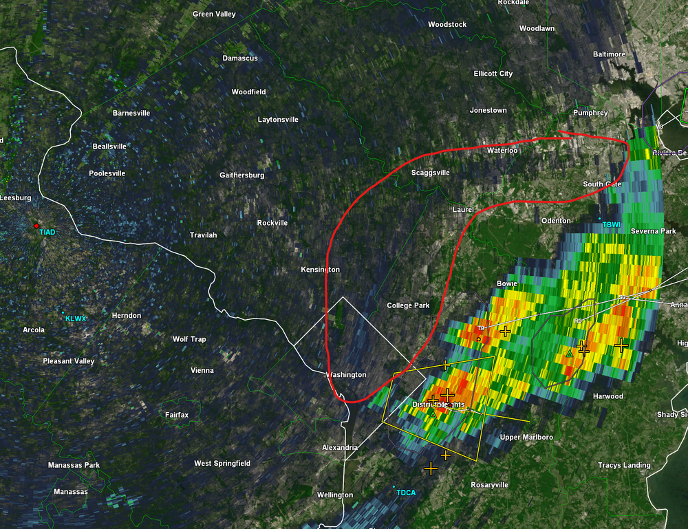
There's a diffuse boundary to the west of the existing storms. That will be something to watch. This is from the TIAD radar.
-
1
-
-
We might have to hope a boundary can set off some storms for folks W of I-95
-
I just barely made it into the watch in terms of counties.
-
Already storming E of 95 in many spots.
-
I somehow never realized there is a mesoanalysis ARCHIVE!
https://www.spc.noaa.gov/exper/ma_archive/
That's some decent fun going through our big events. Seems like some imagery is missing but there's enough there to have some fun for weather nerds.
-
2
-
 2
2
-
-
Pretty strong CAPE already indicated for this early hour on SPC mesoanalysis - core of it it suns from NE Maryland down to the Potomac, essentially over the Bay.
-
14 minutes ago, H2O said:
Doesn’t have a name but near silver beach which is bay side way south of chincoteague
Hope you miss out on the potential 100 degree weather down there!
-
1
-
-
31 minutes ago, H2O said:
I’ll take some beach storms
Which beach are you at? I'm thinking MBY will be a snoozer today.
-
Much of the guidance is almost nothing if you are west of I-95 in most of the area. FV3 Hi-res is still decent. But east seems to be very much favored today.

2023 Mid-Atlantic Severe Wx Thread (General Discussion)
in Mid Atlantic
Posted
Several higher end events I think have. BUT - like mentioned above it has to clear out soon enough and of course every other factor can't go wrong either.
No massively high mid level lapse rates with this it seems - so failure modes are still very real