
Kmlwx
-
Posts
12,579 -
Joined
-
Last visited
Content Type
Profiles
Blogs
Forums
American Weather
Media Demo
Store
Gallery
Posts posted by Kmlwx
-
-
Just now, Maestrobjwa said:
Not to mention that's not even a real rebuttal?
P.S. "RMPL"?
My less direct way of saying "read more, post less"
But now not so subtle lol.
I just went back and checked... The map that the person posted was the Euro ensemble control... Not even the OP
-
Except in a few cases - as soon as somebody starts saying things like
"my vast years of knowledge"
I know to stop taking them seriously. The true ones that have years of experience don't flaunt them overtly like that.
PSU, Bob Chill and all of the degreed mets on here don't flaunt "I'm better than you because I have decades of observation"
Take notes certain people...
It's like somebody simply saying as a rebuttal "I've done my research"
RMPL
-
11 minutes ago, stormy said:
I have never been a big fan of the 15 day EURO but it was posted here a few days ago amind a big splash so I figured I would post it.
The more I read your thoughts, the more I think we could be friends!!
Don't take anything you perceive as an insult seriously. You're question, "is this a serious post" prompted a reply. I gave the reply and we are fine.
The OP Euro is NOT the same as the Euro Control...if that's indeed what you posted. Euro control is a single member of the ensembles with no perturbed conditions initially. It's NOT the OP Euro and has little value other than being a single member of the EC ENS
ETA: You literally did post the Euro ensemble control member. Not even the OP Euro run... I went back and looked. It's a single ensemble member.
-
 2
2
-
 1
1
-
-
1 minute ago, poolz1 said:
Let's get the digital snow thread cranking. You would thing we would start seeing threats in the LR on the ops here soon. That WB NAO is just a thing of beauty. Maybe a bit of patience is needed? D10-15 with a PAC that seeds some Arctic air into the pattern may really kick things off.
Big storms typically wait until the NAO is on the rebound towards neutral or positive
-
1
-
-
6 minutes ago, Maestrobjwa said:
Why in the world are you looking that far ahead?? Stay in the present day, dang it! We're still figuring out THIS winter--mercy, dude!
It's Ji...
-
1
-
-
1 minute ago, psuhoffman said:
It's the DC area. Way too many people are a bad combination of miserable, picky, and demanding.
This is not unique to this area. People just suck nationwide or even globally. It's very sad.
Back on topic though....imagine if that tropical system and that digging trough were configured a bit differently lol-
3
-
-
It may be worth telling Ashley (I can as well) that Alan Henney (a local news/crime follower) and I run a Zello group dedicated to local breaking news and crime (as it happens essentially). It's much more focused on police/fire - but there could be some crossover there. We don't do any forwarding to authorities that much - but many of the members that monitor the channel are local reporters (freelance or pro) and many have some connection to local public safety. We have several hundred "members" - the channel is PW protected as well to prevent "riff raff" from joining.
I don't think we would want to merge the groups of course - but it may be a way to coordinate or work together.
-
Will they QC the reports? I can only imagine what this will lead to if a "friend of a friend" messages that they see a "tornado" and somebody reposts that....90% chance it's scud or other cloud phenomenon.
-
1
-
-
Count me in to help in whatever way is needed. I'm in Montgomery County - but it sounds like this would not be limited to PG?
-
BWI: 8.2"
DCA: 5.5"
IAD: 12.2"
RIC: 1.5"
Tiebreaker SBY: 1.0"
-
1
-
-
4 minutes ago, WxUSAF said:
Definitely think the mountains will get some flakes and possibly light accumulations over the next 7-14 days.
There's also been some hints at some sort of big storm system (maybe tropical in origin?) going well off the coast or perhaps closer-in...but obviously it could just be the GFS doing it's weird super long range stuff.
-
A few runs have had a signal in that timeframe recently! Let's will this one in!
-
2 minutes ago, WEATHER53 said:
Ok so if going to be perceptible then should be underway soon
Recall that in 2017, I believe in the DC area it was like 80%+ total. This will be like 30% locally. So whatever perceived darkness people felt here (I was in SC for that) - it will be much less than that.
-
1 minute ago, WEATHER53 said:
I’m thinking if it does dim some that around us itvwould be between 2-3pm?
Peak is 1:18pm for Colesville.
-
Just now, WEATHER53 said:
Even with cloudy skies, won’t it get a bit darker still?
Might be discernable to a solar sensor - not sure it'll be detectable in dreary conditions to the naked eye here in Maryland. Perhaps down in Texas and similar spots. Less than 50% will be obscured here. Even in places like Texas - it won't be a pitch black darkness eclipse since part of the disk will still be uncovered (ring of fire).
-
46 minutes ago, yoda said:
Looks like a rainy day

Yup...options are to watch online, miss it, or try to drive/fly/travel to a clearer area.
-
There is some glimmer of hope on the 6z GFS for the DC area. The problem is the clouds on that run clear out a bit too late (21z looks decent) - but by then the eclipse will be over.
-
Latest GFS runs do *not* look promising for being able to observe this locally, unfortunately. Heck..the GFS even gets a little tongue of supercell composite parameters up into our SE zones.
-
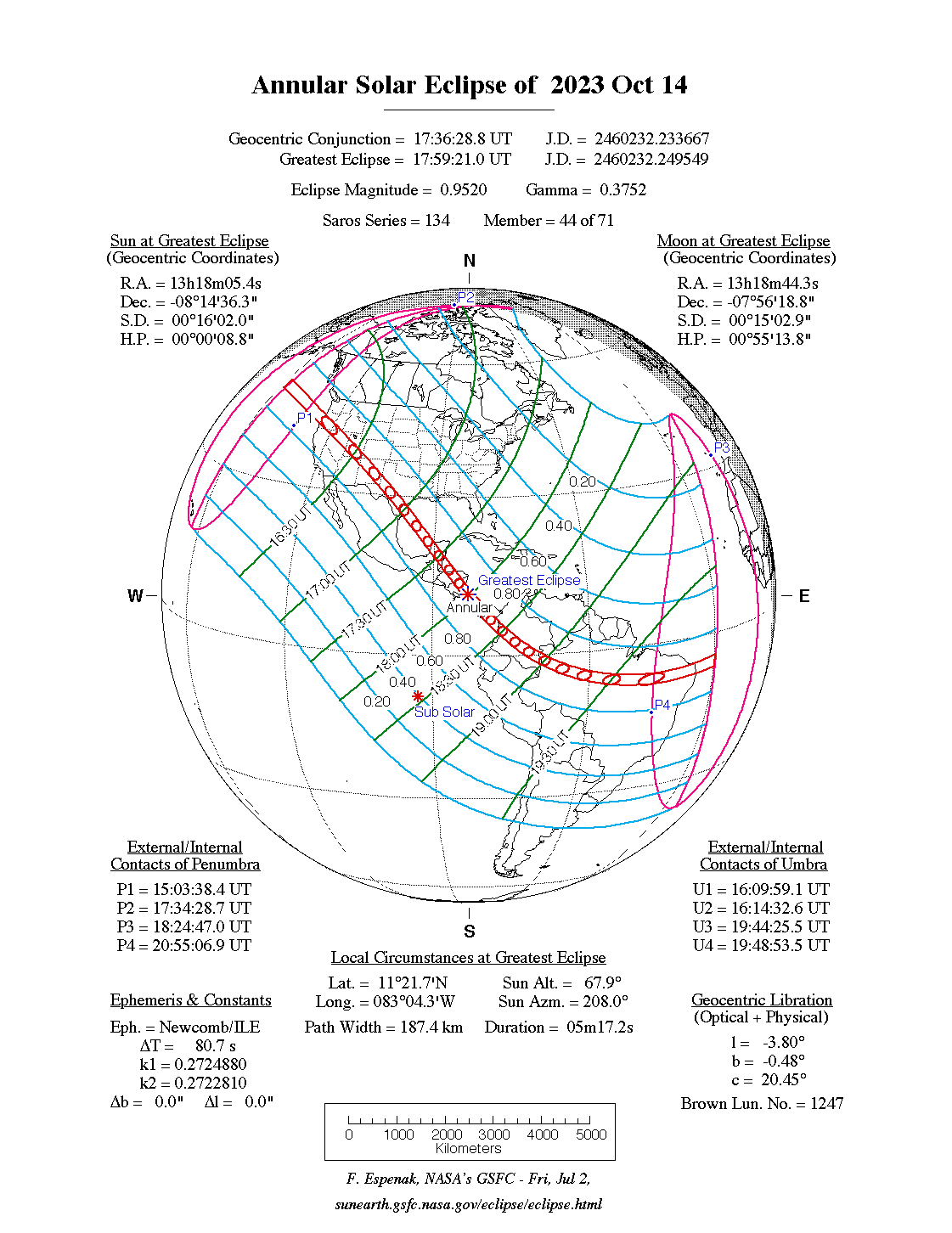
2 hours ago, Jebman said:
This puppy is gonna be about ~93-95 percent annular here. Trying so hard to find eclipse glasses.
Amazon had plenty in stock as of the other day - maybe not now...
-
1 hour ago, Stormchaserchuck1 said:
Looks like that is close to Jebman!
I would chase it if I still lived out West, in northern CA. Drive up north of Ashland, on the beautiful coast.
Wait until the April 2024 one. Annual Eclipses never get pitch black. Still cool and such - but probably not worth the crowds. Somebody describe Annular Eclipses as similar to going to see your favorite band and leaving after the support band before your band ever takes the stage.
-
Didn't see a dedicated thread - so this may have been mentioned in the obs or banter threads.
October 14th will feature a partial annual solar eclipse in our area. A full-on annual eclipse will be visible in other parts of the country. Too far out to estimate cloud cover at this time but GFS is promising for having the sun out that day at this range.
I'll be trying to get a few crude pics with my telescope and solar filter! Don't forget to use solar filter glasses if you're viewing it - not safe without!
Maximum IMBY will be around 1:18pm ET that day.
-
1
-
1
-
-
DCA gusted to 30 knots.
-
Also - the stuff over the KDOX radar area has more convective looks to it. Wouldn't be surprised if there are some brief spinnys or gustnados with that stuff.
-
2
-
-
Just now, dailylurker said:
The wind is getting noticeable stronger here in AA County. I live in a wooded area. It goes from calm and silent to hearing a gust coming through the forest from the SE. It's becoming more frequent and stronger.
Will certainly be interesting to see how the wind forecasts fare. On one hand, the storm is weakening...but there is still that pressure gradient and the system will be getting closer.
December Mid/Long Range Discussion
in Mid Atlantic
Posted
It’s also an ensemble mean and thus will appear smoothed.